
Pricing Change
New pricing for orders of material from this site will come into place shortly. Charges for supply of digital images, digitisation on demand, prints and licensing will be altered.
Balmerino Abbey, Church


Church (Medieval), Monastery (Medieval), Presbytery (Medieval)
Site Name Balmerino Abbey, Church
Classification Church (Medieval), Monastery (Medieval), Presbytery (Medieval)
Canmore ID 223460
Site Number NO32SE 2.06
NGR NO 35797 24651
Datum OSGB36 - NGR
Permalink http://canmore.org.uk/site/223460


- Council Fife
- Parish Balmerino
- Former Region Fife
- Former District North East Fife
- Former County Fife
Archaeological Evaluation (15 March 2007 - 23 March 2007)
NO 357 246 A programme of archaeological investigative works was undertaken between 15-23 March 2007 in respect of the proposed development of land adjacent to Balmerino Abbey. The evaluation consisted of a geophysical survey and seven trenches covering approximately 5% of the development area. A common stratigraphic sequence was exhibited across all of the trenches in the development area, with a mid brown
slightly sandy silt over a slightly varying gravel subsoil, which was a raised marine deposits of Devensian age. No significant archaeological features were identified during the course of the archaeological evaluation.
Report deposited with Fife Council Archaeology Unit and archive with RCAHMS.
Funder: Gilberts on behalf of Headon Developments Ltd.
Field Visit (March 2010)
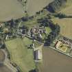
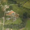
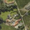
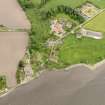
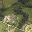
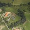
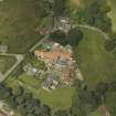
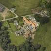
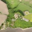
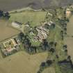
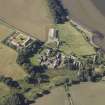
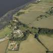
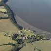
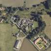
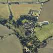
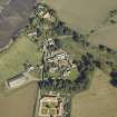
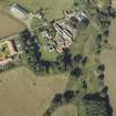
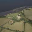
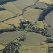
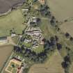
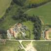
The Cistercian abbey of Balmerino is situated on a terrace overlooking the Tay estuary. Founded in 1226/7 by Alexander II and Queen Ermengarde, it was burned by the English in 1547 and raided by reformers in 1559. After the Reformation the abbey was granted to a series of commendators, who may be responsible for some of the changes which may be seen in the buildings. It was subsequently erected into a lordship for the Elphinstone lords of Balmerino. However, most of the demolition of the surviving buildings appears to have carried out in the early seventeenth century by the second Lord Balmerino for use in the repair of the church at Monifieth.
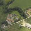
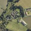
The Monastic Buildings
The surviving features comprised fragments of the abbey church (NO32SE 2.06), the east range, the freestanding building to the east known as the Abbot’s House (NO32SE 2.01) and the large two storey building known as the Abbey Barn to the north (NO32SE 2.02), which was incorporated in the Improvement Period farmsteading (NO32SE 2.04). Nothing of the precinct wall now remains. Campbell (1899, 301) speculates about its course across the field to the south of the abbey church, which is now partly occupied by the almshouses. In this area, he observed a ridge from east to west across the field and identified it as the line of the wall. Although the plough had disturbed some stone work in this area on the date of survey, there was no visible topography to support it. Geophysical survey would be the best method of investigating this possibility.
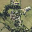
The abbey is laid out according to a standard Cistercian design, but with the cloister to the north, as at Melrose. Nothing of the north and west range survive except for the raggles of the return of the cloister walls on the church and east range walls. Indeed, it is by no means certain that a west range ever existed since there is no raggle for a parallel wall to make the other side of the range, although there is space for it; because the facings of the wall have been robbed at this point, a range may be inferred. However, the basal chamfer of the cloister wall along the north side of the church runs under the raggle which suggests that the original design of the west range had been changed. Campbell refers to a large building used as stables in the area of the farmhouse, which may have been the west range designed to provide accommodation for the conversi (Campbell 1899, 298).
The east range does not now extend far enough to show any trace of the other wall of the north range. It still stands to first floor level, and to the roofline on two sides of the chapter house. This building with its large mullioned windows and late Gothic vaulting is the most interesting architectural survival on the site. Its north end has been demolished and altered in its conversion to a house for the commendator. The east range includes, from south to north: the sacristry, the chapter house, the stairs to the dormitory, a passage or slype and some cellars, the latter probably belonging to the commendator’s house. The foundations of two parallel walls, revealed in the Scotia excavations to the north of the east range and which were aligned with it, have been interpreted as the east range extending 7–8 m further to the north. The refectory may be presumed to lie in the north range.
The so-called Abbot’s House (NO32SE 2.01) situated 35 m to the east is a two bay structure with a vaulted basement. Aligned on the same orientation as the rest of the monastery, it measured about 9.5 m by 7.5 m overall, on the assumption that the two basement chambers are of equal size, but it cannot have been much longer due to the cut of the river terrace immediately to the north. Its walls are 1 m thick and are partly faced with thin rubble slabs with some squared ashlar work, suggesting that it had been relieved of its dressed stone. The quoins of the openings are well-constructed in grey sandstone ashlar, as is the vault. There is a chamfered round arched entrance between the two chambers and window lights to east and west in the surviving chamber, with chamfered arrises. A secondary entrance has been cut in the west wall to the south of the window opening, which has been blocked and a press arranged in the blocking. The base of the window in the east wall has been partially blocked. As it stands, it would be small for an infirmary, the suggested alternative to an Abbot’s House. The shallow arched openings of the windows and the round-arched door between the two basements suggest a late medieval date. Campbell notes that it was once called the Commendator’s House and that this became the residence of Lord Balmerino (Campbell 1899, 299). He notes that it was once approached by a stair on its west, now gone, and had another on the east leading to a garden and a kitchen entrance, which may be the opening in the west of the basement.
To the north of the cloisters one abbey building still stands, the so-called Abbey Barn (NO32SE 2.02). This building measures 20 m WSW and ENE by 7.2 m in breadth over brown sandstone rubble walls, 0.9 m in thickness, increasing to 1.2 m at the gable. The building is a parallelogram aligned with the cloisters at the gable but orientated obliquely to the cloisters along its length, probably to avoid existing structures at its east end. It stands two storeys in height and has a steeply pitched roof. There is a scarcement along the inside of the walls above the ground floor windows to support the first floor joists. Any original window lights in the first floor might be expected to have dormers, since no obvious sign remains in the stonework. The skewput on the north-west corner of the building is decorated with a shield bearing an unidentified armorial device.
There is an entrance with a deeply chamfered gothic arch of late thirteenth century date 6 m from the west gable and another wider opening with similar chamfered quoins some 5 m further east. This is a double width entrance suitable for a barn, but its lintel is modern timber, and a two centred arch would leave a trace in the stonework above the entrance. The original opening could have been widened after the Reformation. The domestic scale of the entrance to the west is inappropriate in a barn and there would be less need for a first floor in a barn, although a loft would be a possibility. In between the two entrances there is a slit window with a square head, again of a domestic character. The excavations by Scotia revealed an extensive area of cobbles to the west of the building, with a distinct camber suggesting a roadway. The foundation of a thick wall ran up to the south end of the west gable on the same alignment, which may be the remains of a precinct wall enclosing the outer court of the monastery. Scotia also excavated a kiln, probably of seventeenth century date, in the east end of the barn.
Visited by RCAHMS (PJD) March 2010
Field Visit
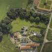
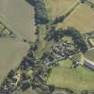
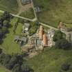
NO32SE 2.06 CHURCH 223460
The church has been almost entirely demolished, except the N wall, which still stands in places to as much as 3m in height. The overall plan was recovered despite the robbing of the E end to its foundations. The church is cruciform and measures about 66m in overall length by 16m in breadth over stone walls 1.3m in thickness. In the N transept, where the walls are thicker at 1.5m, the stonework is dressed ashlar blocks of grey-brown sandstone, with a deep chamfered base and rounded drip course above, visible on the E face. This base course was reduced to a narrow chamfered plinth along the cloister side of the church wall, and apart from the base courses of dressed ashlar the rest was refaced in thin pieces of rough-coursed stone. The W front of the church had a similar drip course and deeply chamfered base. From the surviving remains it had a square E end or presbytery, marked on the S by a low bank of grass c1m in width, but the N and E walls were completely absent. The exact dimensions of the presbytery may be estimated at 18m in length from the crossing on the basis of the grass-covered bank which appears to have been created following an excavation and clearance of the site in 1896 (Campbell 1899, 291). It is presumed that it had the same internal breadth at 10.6m as the nave, measured from the buttresses at the W front. There is no visible trace of a change in level for a high altar. The N transept includes a chapel on the E side for which an aumbry, or sacrament house was inserted subsequently into the N wall. A pillar base preserved midway along the W wall indicates that the transept was divided into two bays, suggesting that there were two chapels. A quintuplet pillar base is offset to the E on the N wall indicating the depth of the chapel, and the arches that held up the roof. At least two flagstone slabs survived under this pillar base to indicate the nature of the flooring. The S transept is marked on the ground by grass-covered banks in the same way as the presbytery, but matches on plan the layout of the N transept. The nave has a single side aisle to the S of which it is now impossible to say whether it is original or not. However, the aisle is divided into seven bays by the grass-covered pillar bases of the arcade, which are more or less evenly spaced at c.5m across, except for the two nearest the crossing and that at the W end that are about wider at c6m across. These pillars do not match with the four bases of triplet wall shafts on the N wall, which are spaced at c.10m, 4m, 6m, 10m and 8m respectively, and would suggest that the aisle is secondary. Fawcett has argued that this is related to the functional and liturgical requirements; the choir filling the first bay between the NW crossing pillar and the first blank pillar where the pulpit was located; in the next space was the retro-choir, between the pulpit and the rood screen; beyond it would have been a nave sanctuary; then the lay brethren’s choir, and finally a space for the laity at the W end (Fawcett 2008). Fawcett also argues for a wooden roof for the nave, while the single shafted pillar in the NW corner of the N transept does not suggest there was sufficient support for vaulting there either. The bases of the four crossing pillars were identified by a circular mound of stone and the butt end of the footing of the presbytery wall on the SW and SE respectively and by a hollow on the NE and a pillar base on the corner of the nave and transept on the NW. The latter is important in showing that the pillars of the crossing were composed of triplet shafts on each face, which mimic the pillar base on the N wall of the transept. The W entrance of the church, which was removed by the National Trust for Scotland in an excavation by James Kenworthy in 1980, and replaced by a rustic stair, was about 3m across. The base of the central pillar with two door stops indicating a double door still sits on the ground near the entrance. The jambs of the door have been robbed of most of the dressed stone and the N jamb has been incorrectly repaired. The S jamb retains the badly weathered basal stones. The W front displays the heavily weathered remains of two buttresses one to either side of the doors in the same dressed ashlar seen elsewhere. A third buttress on the W front at the end of the S aisle wall is about 2.2m square and may have been used for a newel stair. There is no visible join in the surviving ruin to indicate a difference in phasing for the S aisle. Apart from the W doors, there was an entrance, 1.8m in width, in the W of the N transept that led from the cloister to the N transept near the crossing. This provided daytime access for the monks to the choir. An entrance that led from the cloister into the W end of the nave is apparently secondary and includes a recess immediately to its W which may indicate a narrowing of an earlier opening from c.2m to 1m. The quoins on the E of the opening are only roughly dressed. This entrance provides direct access into the bay identified by Fawcett as the lay-brethren’s choir.
Visited by RCAHMS (PJD) March 2010

