
Pricing Change
New pricing for orders of material from this site will come into place shortly. Charges for supply of digital images, digitisation on demand, prints and licensing will be altered.
Dundee, Old Tay Bridge


Railway Bridge (19th Century)
Site Name Dundee, Old Tay Bridge
Classification Railway Bridge (19th Century)
Alternative Name(s) River Tay; Tay Railway Bridge; Firth Of Tay; Outer Tay Estuary
Canmore ID 31698
Site Number NO32NE 17
NGR NO 39162 27844
Datum OSGB36 - NGR
Permalink http://canmore.org.uk/site/31698


- Council Dundee, City Of
- Parish Dundee (Dundee, City Of)
- Former Region Tayside
- Former District City Of Dundee
- Former County Angus
NO32NE 17 39162 27844
Location formerly entered as NO 390 292 to NO 395 263.
For (successor and present) Dundee, Tay Railway Bridge (adjacent to W), see NO32NE 11.
For lists of related buildings and shipwreck, see under NO32NE 11.
REFERENCE: Scottish Record Office:
Picture Postcards by Valentine, Dundee.
Fallen Girders from river level.
Broken piers from bridge.
1879 GD1/558/3 AND 4.
Engineer: Sir Thomas Bouch (Old Bridge)
Opened 1878.
(Undated) information in NMRS.
Trusses from this bridge were re-used in Victoria Bridge, Caputh (NO 0889 3956), for which see NO03NE 26.
J R Hume 1977.
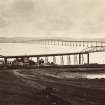
This bridge was designed by Thomas Bouch and built for the North British Rly; construction was started by Charles de Bergue and completed by Hopkins, Gilkes & Co of Middlesborough. It measured 10638 ft (3243.3m) in length, comprised 86 spans and carried the single track 77 ft (23.5m) above high water. The bridge opened for traffic on 1 June 1878 and failed under pressure of wind in a gale on the night of 28 December 1879; faults and defects in design, construction and maintenance were revealed by the subsequent enquiry.
M Smith 1994.
Underwater remote sensing (using side-scan sonar and echo-sounding) has revealed a series of columnar bodies, broken into segments, lying on the riverbed at the S end of the bridge. With the aid of archive material, these have been interpreted as the remains of the eleven twin brick uprights (numbered 4 to 14 from the S) that survived the disaster but were demolished after the construction of the new bridge. These piers (together with nos. 1-3 to the S) supported the southernmost 1550 ft (472m) of the structure, the only part that was built to Bouch's original plan.
R W Duck and W M Dow 1994.
This bridge formerly carried the Edinburgh-Aberdeen main line of the North British Rly. across the estuary of the River Tay between the parish of Forgan (North-East Fife District, Fife Region) and the City Parish of Dundee (City of Dundee District, Tayside Region and former county of Angus), to the S and N respectively.
Information from RCAHMS (RJCM), 5 January 1996.
Site recorded by Maritime Fife during the Coastal Assessment Survey for Historic Scotland, Fife Ness to Newburgh 1996.
The location assigned to this record defines the midpoint of its length. The available map evidence indicates that it extended from NO c. 39056 29226 to NO c. 39570 26345.
The piers of this bridge extend down the E side of the successor (present) bridge between NO 38993 29160 and NO 39566 26364.
Information from RCAHMS (RJCM), 21 April 2006.
Publication Account (2013)
TAY RAIL BRIDGE
The first Tay Bridge (NO 39162 27844, NO32NE 17) was a single-track lattice-girder bridge designed by Sir Thomas Bouch, proponent of the idea that contemporary structures were over-designed. Built in 1871-8 it was at two miles the longest bridge in the world at that time. It is axial to Cox’s Stack, and James Cox was a principal funder. On December 28th 1879 a force ten gale brought down the high girders and a train carrying 75 people plunged into the River Tay. The Inquiry into the incident blamed insufficient cross-bracings and fastenings, but the design meant its fall was inevitable. The stumps of the old piers remain visible downstream as eloquent reminders of the cost that can come with engineering advance.
M Watson, 2013

