
Pricing Change
New pricing for orders of material from this site will come into place shortly. Charges for supply of digital images, digitisation on demand, prints and licensing will be altered.
East Huntingtower


Henge (Neolithic) - (Bronze Age)
Site Name East Huntingtower
Classification Henge (Neolithic) - (Bronze Age)
Alternative Name(s) East Huntingtower 1; Huntingtower Cropmark Complex
Canmore ID 26876
Site Number NO02SE 27
NGR NO 08133 24951
Datum OSGB36 - NGR
Permalink http://canmore.org.uk/site/26876


- Council Perth And Kinross
- Parish Tibbermore
- Former Region Tayside
- Former District Perth And Kinross
- Former County Perthshire
NO02SE 27 0814 2495
For other elements of the Mains of Huntingtower cropmark complex, see NO02NE 39, NO02NE 86, NO02NE 87, NO02NE 100, NO02NE 151, NO02SE 49, NO02SE 66 and NO02SE 67.
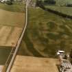
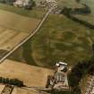
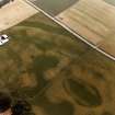
(NO 0812 2496) Crop marks: circular enclosure and lines.
Visible on J K St Joseph air photographs TW 46, ACD 30, ADV 2.
(Undated) information in NMRS.
Class 1 henge, approximately 120 ft in diameter, entrance in E, bank outside ditch. There are several henges and a cursus here.
H A W Burl 1969; Information from Notes written by J X W P Corcoran Glasgow University.
Possible henge. Oval pit immediately outside the entrance. Linear feature that bisects it has been shown by excavation to be modern.
G Barclay 1983.
This enclosure is plotted as a Class I henge on a distribution map of henge monuments, ring-cairns, pit-circles and recumbent stone circles covering central and eastern Scotland (RCAHMS 1994, 39, fig. A).
Information from RCAHMS (ARG) 17 October 1997.
Scheduled as [part of] 'Mains of Huntingtower, henges, enclosures, pits and road WSW of... the remains of a neolithic henge, two prehistoric enclosures, five prehistoric roundhouses, dispersed groups of pits and a broadly-parallel alignment of pits representing a Roman road [surviving] as a complex group of buried archaeological features... on a river terrace in cultivated land to the north-west of Perth, 1km south of the River Almond and at 35m above sea level.'
Information from Historic Scotland, scheduling document dated 25 November 2008.

