|
Photographs and Off-line Digital Images |
PT 6802 |
John Dewar |
Oblique aerial view |
7/1975 |
Item Level |
|
|
Photographs and Off-line Digital Images |
PT 6803 |
John Dewar |
Oblique aerial view
|
7/1975 |
Item Level |
|
|
Photographs and Off-line Digital Images |
B 17418 CN |
RCAHMS Aerial Photography |
Oblique aerial view. |
1989 |
Item Level |
|
|
Photographs and Off-line Digital Images |
B 17419 CN |
RCAHMS Aerial Photography |
Oblique aerial view. |
1989 |
Item Level |
|
|
Photographs and Off-line Digital Images |
B 17420 CN |
RCAHMS Aerial Photography |
Oblique aerial view. |
1989 |
Item Level |
|
|
Photographs and Off-line Digital Images |
B 18970 |
RCAHMS Aerial Photography |
Oblique aerial view. |
1989 |
Item Level |
|
|
Photographs and Off-line Digital Images |
B 83193 PO |
Cambridge University Collection for Aerial Photography |
Oblique aerial view |
17/7/1961 |
Item Level |
|
|
Photographs and Off-line Digital Images |
B 83194 PO |
Cambridge University Collection for Aerial Photography |
Oblique aerial view |
17/7/1961 |
Item Level |
|
|
Photographs and Off-line Digital Images |
PT 10257 PO |
Cambridge University Collection for Aerial Photography |
Oblique aerial view |
17/7/1961 |
Item Level |
|
|
Photographs and Off-line Digital Images |
PT 10898 PO |
Cambridge University Collection for Aerial Photography |
Oblique aerial view |
2/8/1956 |
Item Level |
|
|
Photographs and Off-line Digital Images |
PT 13988 PO |
Cambridge University Collection for Aerial Photography |
Oblique aerial view |
19/7/1960 |
Item Level |
|
|
Photographs and Off-line Digital Images |
PT 13989 PO |
Cambridge University Collection for Aerial Photography |
Oblique aerial view |
19/7/1960 |
Item Level |
|
|
Photographs and Off-line Digital Images |
PT 6804 |
John Dewar |
Oblique aerial view. |
1975 |
Item Level |
|
|
Photographs and Off-line Digital Images |
PTD 418/27 P |
Records of Historic Scotland, Edinburgh, Scotland |
Huntingtower, Perthshire
Photographic copy of a plan of the cropmarks.
Similar to plan in G Barclay article in PSAS 112 fig 1 p581, but site numbering is different. |
1977 |
Item Level |
|
|
Photographs and Off-line Digital Images |
C 93659 PO |
Dr Colin and Dr Paula Martin |
Aerial photograph |
16/7/1984 |
Item Level |
|
|
Photographs and Off-line Digital Images |
C 93725 PO |
Dr Colin and Dr Paula Martin |
Oblique aerial view. |
18/7/1984 |
Item Level |
|
|
Photographs and Off-line Digital Images |
C 93726 PO |
Dr Colin and Dr Paula Martin |
Aerial photograph |
16/4/1984 |
Item Level |
|
|
Prints and Drawings |
DC 30919 |
|
Working plan of the Huntingtower area showing the possible archaeological sites traced
from APs. Rough sketch of Proc Soc Antiq Scot, vol. 112 (1982) 580-583 |
1977 |
Item Level |
|
|
Photographs and Off-line Digital Images |
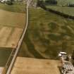
C 73796 |
RCAHMS Aerial Photography |
Huntingtower, oblique aerial view, taken from the ESE, centred on the cropmarks of a henge. The quarry pits of a Roman road are visible in the top half of the photograph. |
12/8/1996 |
Item Level |
|
|
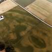
Photographs and Off-line Digital Images |
C 73797 |
RCAHMS Aerial Photography |
Huntingtower, oblique aerial view, taken from the ENE, centred on the cropmarks of a henge. The quarry pits of a Roman road are visible at the right edge of the photograph. |
12/8/1996 |
Item Level |
|
|
Photographs and Off-line Digital Images |
C 73798 |
RCAHMS Aerial Photography |
Huntingtower, oblique aerial view, taken from the NNW, centred on the cropmarks of a henge. |
12/8/1996 |
Item Level |
|
|
Photographs and Off-line Digital Images |
H 87884 CS |
Dr Colin and Dr Paula Martin |
Oblique aerial view centred on the cropmarks of the henge, ring-ditch, enclosure and pits, taken from the E. |
19/7/1989 |
Item Level |
|
 |
On-line Digital Images |
SC 1706342 |
RCAHMS Aerial Photography |
Oblique aerial view. |
1989 |
Item Level |
|
 |
On-line Digital Images |
SC 1706343 |
RCAHMS Aerial Photography |
Oblique aerial view. |
1989 |
Item Level |
|


