
Pricing Change
New pricing for orders of material from this site will come into place shortly. Charges for supply of digital images, digitisation on demand, prints and licensing will be altered.
Newton Of Ballinreigh


Township (Post Medieval)
Site Name Newton Of Ballinreigh
Classification Township (Post Medieval)
Canmore ID 84864
Site Number NN93NW 13.01
NGR NN 9131 3772
Datum OSGB36 - NGR
Permalink http://canmore.org.uk/site/84864


- Council Perth And Kinross
- Parish Little Dunkeld
- Former Region Tayside
- Former District Perth And Kinross
- Former County Perthshire
Field Visit (6 December 1993)
NN93NW 13.01 9131 3772
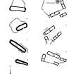
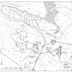
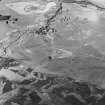
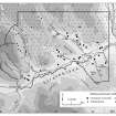
This township is situated on a terrace in the angle between the Glen Fender Burn and the River Braan at the edge of the improved grassland. The remains of at least 28 buildings are arranged in a series of steadings, comprising at least two buildings lying parallel or forming a L- or U-shape, and an enclosure. The buildings are constructed of faced-rubble up to 0.9m in thickness and many have been built on a platform levelled into the slope. A considerable size range is evident, with buildings measuring from 5.1m by 3.3m (Braan93 193) up to 25.1m by 3.9m internally (Braan93 198) with up to three compartments.
A horse-engine platform, measuring 7.2m in diameter, is situated on the W side of one of the buildings (NN 9131 3771, Braan93 194). What may be kilns are situated within the fermtoun at NN 9137 3775 and NN 9133 3770. Irregular, slightly hollowed, trackways run through the settlement, which is also disected by a track branching to the E from the military road from Coupar Angus to Amulree (NN93NW 8). The function of two circular pits (NN 9133 3763 and NN 9133 3773) is not clear.
Most of the buildings are shown as roofed on the 1st edition of the OS 6-inch map (Perthshire 1867, sheets lxxi and lxxii). Of two buildings shown on the 1st edition as unroofed, only one is now visible (Braan93 322), partially overlain by a drystone wall. Two further buildings (Braan93 37 and 321) are not depicted at all and may be earlier elements of the settlement. By the date of the 2nd edition of the OS 6-inch map (Perthshire 1901, sheets lxxi and lxxii), only three of the buildings (Braan93 32, 191, 192) are still roofed and these are shown as roofless on the current edition of the OS 1:10,000 map (1982).
(Braan93 31-37, 191-199, 321-328)
Visited by RCAHMS (DCC) 6 December 1993.
Note (4 February 1998)
A township, comprising thirteen roofed, five partially roofed, three unroofed buildings, two unroofed structures and eleven enclosures is depicted on the 1st edition of the OS 6-inch map (Perthshire 1867, sheet lxxii). Eight unroofed buildings and seven enclosures are shown on the current edition of the OS 1:10000 map (1982).
Information from RCAHMS (AKK) 4 February 1998.

