
North Mains, Strathallan


Barrow (Prehistoric), Cup Marked Stone (Neolithic) - (Bronze Age), Unidentified Pottery (Neolithic)
Site Name North Mains, Strathallan
Classification Barrow (Prehistoric), Cup Marked Stone (Neolithic) - (Bronze Age), Unidentified Pottery (Neolithic)
Alternative Name(s) River Earn; Machany Water
Canmore ID 26005
Site Number NN91NW 17
NGR NN 92600 16200
Datum OSGB36 - NGR
Permalink http://canmore.org.uk/site/26005


First 100 images shown. See the Collections panel (below) for a link to all digital images.
- Council Perth And Kinross
- Parish Blackford
- Former Region Tayside
- Former District Perth And Kinross
- Former County Perthshire
NN91NW 17 9262 1621
For adjacent henge (also excavated), see NN91NW 18.
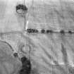
At NN 9262 1621, on level ground at the junction of the River Earn and the Machany Water, there is a tree-covered cairn measuring 44.0m in diameter and 4.0m in height, though a stone dyke encroaches on its N side. There are traces of a ditch round the NW side. An excavation in the top shows the cairn to be composed mainly of large, waterworn stones with an admixture of earth. On the edge of the excavation there are two large stone slabs, on one of which, measuring 1.6m by 1.1m by 0.3m, are some thirty cup marks, the majority very small, but some averaging 2ins in diameter and 1/2ins deep.
Surveyed at 1:2500.
Visited by OS (W D J) 30 May 1967.
(NN 9262 1621) Cairn (NR) Cup marked Stone (NR)
OS 1:10,000 map, (1975)
This round barrow was excavated by G Barclay in 1978-9 in advance of development. It covered a well-preserved old land surface corrugated by spaded ridges.
A roughly circular timber enclosure 7.5m in diameter had been erected on the old land surface. It contained a flint arrowhead, but no trace of burials; this absence may be illusory in view of the high acidity of the soil. A number of light wooden fences was built radiating from the enclosure forming bays into which was dumped material dug from the surrounding quarry ditch. The central enclosure was filled with boulders. The pattern of construction established by the fences and the wall of the central enclosure was maintained to the top of the mound. The barrow was capped by a layer of turf and ultimately a layer of stones, giving it the appearance of a cairn. Two food vessels, a number of cremation deposits, and two probable inhumations had been inserted in the mound.
Radiocarbon dates suggest the mound was built in the early 2nd millenium BC.
G Barclay 1978.
CUCAP photographs of 29 July 1979 show barrow under excavation.
(Undated) information in NMRS.
Excavation (1978 - 1979)
This round barrow was excavated by G Barclay in 1978-9 in advance of development. It covered a well-preserved old land surface corrugated by spaded ridges.
A roughly circular timber enclosure 7.5m in diameter had been erected on the old land surface. It contained a flint arrowhead, but no trace of burials; this absence may be illusory in view of the high acidity of the soil. A number of light wooden fences was built radiating from the enclosure forming bays into which was dumped material dug from the surrounding quarry ditch. The central enclosure was filled with boulders. The pattern of construction established by the fences and the wall of the central enclosure was maintained to the top of the mound. The barrow was capped by a layer of turf and ultimately a layer of stones, giving it the appearance of a cairn. Two food vessels, a number of cremation deposits, and two probable inhumations had been inserted in the mound.
Radiocarbon dates suggest the mound was built in the early 2nd millenium BC.
G Barclay 1978.
Note (29 October 2018)
Date Fieldwork Started: 29/10/2018
Compiled by: ACFA South Glasgow
Location Notes: This panel is displayed at the entrance to the Science Gallery in the National Museum of Rural Life, Wester Kittochside Farm, East Kilbride. It came from the site of North Mains, Strathallan, Perthshire excavated by Dr Gordon J Barclay et al in 1979. This extensive complex comprised a round barrow and a class II henge. The panel was associated with the barrow (Barclay, G.J. 1984. Sites of the third millennium bc to the first millennium ad at North Mains, Strathallan, Perthshire, Proc Soc Antiq Scot 113 (1983): 189-192, with an image of the slab as found in Plate 15).
Panel Notes: This is a large, thin slab measuring approximately 2.1 x 1.6m maximum and 0.3m thick. It is currently mounted on a plinth where the public can both see and touch it. Its decorated front surface is smooth and flat, whereas the rear surface is fractured and rough where is was cut during removal, either in antiquity or at the time of excavation. The excavation report (Barclay 1984, p.189) notes that: 'In the shallow pit dug in 1957 a large cupmarked slab was found lying decorated face down, apparently, left in the condition after the earlier undated disturbance. After the 1957 excavation the slab was left lying decorated face upwards at the edge of the pit. There were about 30 complete or unfinished cupmarks on one surface. In addition there were a number of groups of peck-marks, perhaps the beginnings of cupmarks. The stone was severely damaged some months after the completion of the excavation and has since been removed by SDD (Ancient Monuments) to a place of safety. Any evidence of a relationship between the cupmarked slab, burial K and the stone capping of the mound was destroyed by the earlier excavations.' The damage is clearly visible when comparing Plate 15 from Barclay's report with the current stone. At least 5 prominent cupmarks on the panel's upper edge (four of which were arranged in a diamond shape) are now missing. Recording by ACFA Team South identified 12 probable cupmarks, 3 of which are truncated by the damage to the panel, as well as some of the 'unfinished cupmarks' referred to in the report.

