
Pricing Change
New pricing for orders of material from this site will come into place shortly. Charges for supply of digital images, digitisation on demand, prints and licensing will be altered.
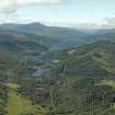
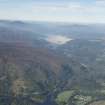
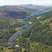
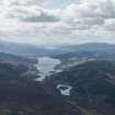
Loch Tummel


Reservoir (20th Century)
Site Name Loch Tummel
Classification Reservoir (20th Century)
Alternative Name(s) Tummel Hydro-electricity Scheme; River Tummel
Canmore ID 171428
Site Number NN85NW 22
NGR NN 8250 5950
NGR Description Centred NN 8250 5950
Datum OSGB36 - NGR
Permalink http://canmore.org.uk/site/171428


- Council Perth And Kinross
- Parish Dull
- Former Region Tayside
- Former District Perth And Kinross
- Former County Perthshire
NN85NW 22 centred 8250 5950
For Clunie Dam (NN 8843 6028), see NN86SE 66.
Loch Tummel
(Reservoir)
Top water level 144m above Newlyn datum [NAT]
OS 1:10,000 map, 1993.
Extends onto map sheets NN75NE, and NN86SE.
This reservoir forms a major element of the Tummel/Garry Hydro-electric Scheme. It has been formed by damming the River Tummel at Clunie Dam (NN86SE 66), and extends across portions of the parishes of Blair Atholl and Moulin.
Information from RCAHMS (RJCM), 20 February 2006.

