
Pricing Change
New pricing for orders of material from this site will come into place shortly. Charges for supply of digital images, digitisation on demand, prints and licensing will be altered.
Strageath Cottage


Temporary Camp (Roman)
Site Name Strageath Cottage
Classification Temporary Camp (Roman)
Canmore ID 25292
Site Number NN81NE 16
NGR NN 8904 1803
NGR Description Centred NN 8904 1803
Datum OSGB36 - NGR
Permalink http://canmore.org.uk/site/25292


- Council Perth And Kinross
- Parish Muthill
- Former Region Tayside
- Former District Perth And Kinross
- Former County Perthshire
NN81NE 16 centred 8904 1803
Not to be confused with Strageath Roman fort (NN 8980 1800), for which see NN81NE 2.00.
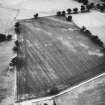
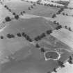
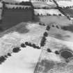
First revealed by air photography, and proved by excavation in 1979, this temporary camp is of elongated plan and is about 13.5 ha (33 acres) in area.
G S Maxwell 1980.
Aerial Photographic Transcription (15 December 1995 - 6 April 1998)
An aerial transcription was produced from oblique aerial photographs. Information from Historic Environment Scotland (BM) 31 March 2017.
Field Visit (26 November 1997)
NN81NE 16 centred 8904 1803
Not to be confused with Strageath Roman fort (NN 8980 1800), for which see NN81NE 2.00.
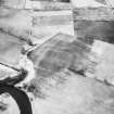
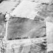
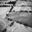
Cropmarks on oblique aerial photographs (RCAHMSAP) reveal a Roman temporary camp, confirmed by small scale excavation (Maxwell 1980), laid out across the relatively flat terrace to the W of Strageath Roman fort. The camp is playing card shape on plan, measuring about 470m from ESE to WNW by about 280m (c. 13.1ha). The NW and SW angles are visible and the ESE end is marked by a very wide and irregular ditch, possibly the product of erosion. Immediately beyond this ditch there is a scatter of at least eight pits.
Ditches marking part of a field-system (NN 81NE 39) and scatters of pits (NN 81NE 20, 64) are also visible as cropmarkings within the area of the temporary camp.
Visited by RCAHMS (DCC) 26 November 1997.
Publication Account (17 December 2011)
This camp is situated on fairly level ground less than 500m west of the Roman fort at Strageath. It was first recorded as a cropmark from the air in 1969 by Cambridge University, and confirmed through further aerial survey by RCAHMS and excavations by St Joseph (Maxwell 1981: 41). However, a Roman camp is clearly marked in this location to the west of Strageath fort and annexes, with four tituli, on Knox’s Map of the Basin of the Tay in 1850. In addition, Maitland refers to a large camp occupying upwards of 30 acres at Strageath (1757: 196), and this could also be this camp.
The camp measures about 470m from WNW to ESE by 292m, enclosing about 13.7ha (34 acres). No obvious entrances are known. Excavations by St Joseph in 1979 recorded that the ditch on the south side was V-shaped, measuring about 1.3m in width and 0.6m in depth
(RCAHMS St Joseph Collection: Notebook 8).
R H Jones.

