
Inishail Church


Crannog (Period Unassigned)
Site Name Inishail Church
Classification Crannog (Period Unassigned)
Canmore ID 23457
Site Number NN02SE 20
NGR NN 0959 2448
Datum OSGB36 - NGR
Permalink http://canmore.org.uk/site/23457


- Council Argyll And Bute
- Parish Glenorchy And Inishail (Argyll And Bute)
- Former Region Strathclyde
- Former District Argyll And Bute
- Former County Argyll
NN02SE 20 0959 2448.
(NN 0959 2448) Crannog (NR)
OS 1:10,000 map, (1976)
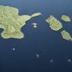
Investigation in 1972 by a naval sub-aqua team under the direction of Dr T D McArdle of Edinburgh University confirmed that this island in Loch Awe is a crannog. It contained a harbour which faced the western tip of the island of Inishail, and which may have been constructed of wood, supported at base by shallow heaps of stones. Only the stones remain. Inside the harbour area the surface is covered with small-size stones to give a sure footing when climbing up on to the crannog.
T D McArdle and C M McArdle 1972; RCAHMS 1975.
Note (1975)
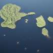
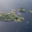
As a result of an underwater survey of Loch Awe undertaken in 1972 by Naval Air Command Sub-Aqua Club under the direction of Dr and Mrs T D McArdle, no fewer than twenty crannogs have been positively identified (The Commissioners are indebted to Dr and Mrs T D Mcrdle for permission to include this information). The tops of many of them are visible as small stony islands, but others are permanently submerged. In at least nine instances their structure can be seen to include timber baulks, which in one example are radially disposed. Causeways linking the crannog to the shore have been detected at five examples and the remains of jetties or of harbours, comparable to that discovered at Milton Loch I (Kirkcudbrightshire) (PSAS, lxxxvi (1952-3), 136), have been noted in six cases. The sixteen crannogs of this group that fall within the boundaries of Lorn are shown on Fig. 79 and are listed below in the order in which they occur from NE to SW, those off the NW shore of the loch being numbered 1-8 and those off the SE shore 9- 16.
(1) 280 m E of Ardanaiseig (No. 307) and 20 m from the shore (NN 091 248).
(2) 50 m from the W side of Inishail (NN 095 244).
(3) 700 m SSE of Ardanaiseig (No. 307) and 20 m from the shore (NN 090 241).
(4) 455 m SE of Larach Ban and 75 m from the S side of Ceann Mara (NN 073 227).
(5) The island known as Càrn an Roin, 520 m E of Achnacarron and 74 m offshore (NN 065 223).
(6) The stony island known as Càrn Dubh, 490 m ENE of Inverinan and 10 m from the shore (NN 001 177).
(7) 115 m SW of Barr Phort and 975 m E of Cruachan (NM 963 104).
(8) Càrn Mhic Chealair, a small stony island 825 m SSE of Cruachan (NM 958 098).
(9) On the S side of the loch opposite St Conan's Church and 55 m from the shore (NN 121264).
(10) 760 m NW of Achlian (No. 302) and less than 100 m from the shore (NN 115 247).
(11) At the NE end of the small bay sheltered by the Inistrynich peninsula and 280 m ESE of Inistrynich (NN 108 235).
(12) 1 km NW of Keppochan and 45 m from the shore(NN 077 223).
(13) 170 m N of Rockhill and 10 m from the shore(NN 071 220).
(14) In a bay 550 m WSW of the Port Sonachan Hotel and 15 m from the shore (NN 042207).
(15) 425 m WSW of Ardchonnell, 290 m NNE of Innis Chonnell Castle (No. 292) and 170 m from the shore (NM 978 121).
(16) Close to the shore some 290 m N of Eredine (NM 968 097)
RCAHMS 1975.

