
Inishail Church


Crannog (Period Unassigned)
Site Name Inishail Church
Classification Crannog (Period Unassigned)
Canmore ID 23457
Site Number NN02SE 20
NGR NN 0959 2448
Datum OSGB36 - NGR
Permalink http://canmore.org.uk/site/23457


- Council Argyll And Bute
- Parish Glenorchy And Inishail (Argyll And Bute)
- Former Region Strathclyde
- Former District Argyll And Bute
- Former County Argyll
NN02SE 20 0959 2448.
(NN 0959 2448) Crannog (NR)
OS 1:10,000 map, (1976)
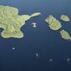
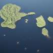
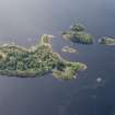
Investigation in 1972 by a naval sub-aqua team under the direction of Dr T D McArdle of Edinburgh University confirmed that this island in Loch Awe is a crannog. It contained a harbour which faced the western tip of the island of Inishail, and which may have been constructed of wood, supported at base by shallow heaps of stones. Only the stones remain. Inside the harbour area the surface is covered with small-size stones to give a sure footing when climbing up on to the crannog.
T D McArdle and C M McArdle 1972; RCAHMS 1975.

