
Coll, Killunaig Church


Cemetery (Period Unassigned), Church (Period Unassigned), Grave Slab(S) (Period Unassigned)
Site Name Coll, Killunaig Church
Classification Cemetery (Period Unassigned), Church (Period Unassigned), Grave Slab(S) (Period Unassigned)
Alternative Name(s) Killunaig; Killunaig Chapel
Canmore ID 21728
Site Number NM26SW 3
NGR NM 2215 6174
Datum OSGB36 - NGR
Permalink http://canmore.org.uk/site/21728


- Council Argyll And Bute
- Parish Coll
- Former Region Strathclyde
- Former District Argyll And Bute
- Former County Argyll
NM26SW 3 2215 6174.
(NM 2215 6174) Chapel (NR) (rems of)
OS 1:10,000 map, (1975)
There are the ruins of a chapel in Killunaig graveyard.
Argyll County Council 1915.
Beveridge (E Beveridge 1903) gives a description of the chapel and adds that there are nine or ten flat slabs within the graveyard; at least one is of West Highland type.
E Beveridge 1903; W Reeves 1854.
Chapel. No trace was seen of any West Highland slabs.
Visited by OS (I S S) 18 June 1972.
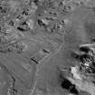
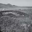
Church, Killunaig: The remains of this medieval church lie within a walled burial-ground at Killunaig Cemetery. The ground levels have risen considerably within the immediate vicinity of the building, and the surface remains comprise walls that appear as low turf-covered mounds and show evidence of masonry construction only on their inner faces to an average height of about 1.5m. The visible portions are, however, of the upper parts of the walls, at about the level of the original wall-head and probably some 2m above the floor of the chapel. The walls are constructed of random rubble masonry laid in lime mortar, and traces of plaster adhere to some inner wall-surfaces.
The church is of simple rectangular plan and measures 10.9m in length from E to W by 5.1m transversely within walls 0.6m in thickness at the sides and 0.8m at the ends; the end-walls were originally gabled, but subsequently have been reduced to a height corresponding with that of the side-walls. There are no surviving features of interest above ground, but limited clearance of some sections of the walls revealed a complete and well-preserved slit-window in the centre of the E gable-wall, the lower half of a window-embrasure in the S side-wall, and the E jamb of a window towards the E end of the N side-wall. The windows appear to have been of a uniform character. The entrance-doorway, which was not located, probably occupies a position towards the W end of one of the side-walls.
The building can be ascribed to the later Middle Ages and, although of comparatively small dimensions, may tentatively be identified as the medieval parish church of Coll. The church of St Fynnoga or St Findoca of Coll first comes on record in 1433. Little is known of its history, and the date at which it was abandoned for worship prior to the 18th century is not recorded. The site is variously described as Kilynaig, Cill Ionnaigh or Kilfinnaig. There is no evidence to show that the associated burial-ground had ever been enclosed, and the existing boundary-wall dates from the later 19th century.
(The RCAHMS describes seven 17th and 18th century funerary monuments in the grave-yard, but make no reference to any West Highland slabs here.)
RCAHMS 1980, visited 1973; Orig Paroch Scot 1854; I B Cowan 1967; J Blaeu 1654.
NM 2214 6170 An archaeological evaluation was undertaken on the site of a proposed southward extension of the cemetery at Killunaig. Within the grounds of the existing cemetery are the remains of a building, tenatively identified as the site of the late medieval church of St Fynnoga or Findoca of Coll (NMRS no NM26SW 3). A number of features, including cists and ash spreads, as well as artefacts including pottery, flints, bronze objects and hammer stones have been reported previosly from sand dunes to the W of the existing cemetery.
The proposed extension measured approximately 26m E-W by 13m N-S, and was located in an area of stabilised sand. Following an unsuccessful augering survey, four trenches were opened by hand, uncovering an area of approximately 30 square metres. Three trenches were excavated to a depth of 1.2m. Two of these trenches were then sondaged to 1.5m at which level the water table was reached. These trenches were then cored to a depth of 2m. No archaeologically significant horizons or finds were made.
A report has been deposited with the NMRS.
Sponsor: Argyll and Bute District Council.
R J Strachan 1995.

