
Hyskier, Lighthouse


Lighthouse (20th Century)
Site Name Hyskier, Lighthouse
Classification Lighthouse (20th Century)
Alternative Name(s) Oigh Skeir; Oigh-sgeir Lighthouse; Hyskeir Lighthouse
Canmore ID 106734
Site Number NM19NE 1
NGR NM 1552 9626
Datum OSGB36 - NGR
Permalink http://canmore.org.uk/site/106734


- Council Highland
- Parish Small Isles
- Former Region Highland
- Former District Lochaber
- Former County Inverness-shire
NM19NE 1 1552 9626
Name: Hyskeir (1904)
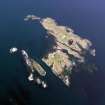
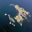
Location: N56 58 W6 41 Sea of the Hebrides, 33 miles W of Mallaig
Designed and built: D A Stevenson
Light first exhibited: 8 November 1915
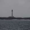
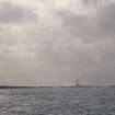
Description: circular stone tower, painted white
Height of light above MHW: 134ft (41m)
Height of tower: 128ft (39m)
Light source and characteristics: W Gp Fl (3) ev 30 secs. 250W metal halide lamp: 788,000cp: nominal range 24nm
Fog warning apparatus: electric (1) ev 30 secs
Manning: watched (helicopter transfer from Oban)
Fog signal tower demolished 1985
C Nicholson 1995.
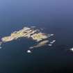
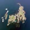
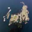
Hyskier (Oigh Sgier) lighthouse: This rock lighthouse was built in 1904 by D A Stevenson on an extensive but low-lying projecting rock outcrop in waters between the Little Minch and the Sound of Mull. A small group of buildings was erected at the base of the 39m-high tower, and there were formerly keepers' gardens (the 'rock garden') but no shore station was built, the keepers' families being accommodated at Pulpit Hill, Oban.
The light was electrified (to 788,000 maximum candlepower) in 1959 and saw the early use of aerial resupply, a helicopter pad being constructed in about 1972 for that purpose. The Moderator of the General Assembly visited the lighthouse by helicopter in 1974, and the light was automated in 1997.
R W Munro 1979; K Allardyce and E M Hood 1986; K Allardyce 1998.
The location (NM 1552 9626) cited for this record is derived from that (N56 58.2 W6 40.9) cited in navigational publications.
Information from RCAHMS (RJCM), 15 October 2003.
Admiralty List of Lights 1980.

