
Pricing Change
New pricing for orders of material from this site will come into place shortly. Charges for supply of digital images, digitisation on demand, prints and licensing will be altered.
Sands Of Forvie


Ring Cairn (Bronze Age)
Site Name Sands Of Forvie
Classification Ring Cairn (Bronze Age)
Alternative Name(s) East Cottage; Sands Of Forvie Nature Reserve
Canmore ID 20856
Site Number NK02NW 3
NGR NK 0108 2628
Datum OSGB36 - NGR
Permalink http://canmore.org.uk/site/20856


- Council Aberdeenshire
- Parish Slains
- Former Region Grampian
- Former District Gordon
- Former County Aberdeenshire
NK02NW 3 0108 2628
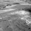
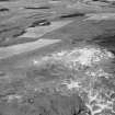
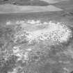
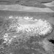
In 1951, a ring cairn, lying on a sand-covered gravel ridge adjacent to an Late Bronze Age/Early Iron Age settlement (NK02NW 2) was revealed in blown sand and excavated.
W Kirk 1953.
Kirk is of the opinion that the settlement and cairn are contemporary, on the evidence of pottery found both in the huts, and in an apparently primary cremation in the ring cairn, but Henshall states that similar pottery discovered in recumbent stone circles at Old Keig and Loanhead of Daviot has been shown to be secondary.
A S Henshall 1962.
A ring cairn, at NK 0108 2628, as described and planned.
Surveyed at 1/2500
Visited by OS (RL), 27 August 1970.
Air photograph: AAS/97/13/CT.
NMRS, MS/712/29.
Scheduled with NK02NW 2 as 'Sands of Forvie, hut circles and ring cairn 1020m E of East Cottage... a complex of prehistoric remains...'
Information from Historic Scotland, scheduling document dated 30 March 2009.
Measured Survey (28 March 2000)
RCAHMS surveyed Sands of Forvie hut circles and ring cairn on 28 March 2000 with plane table and alidade producing a location plan at a scale of 1:250. The plan was used as the basis for an illustration, produced in ink and finished in vector graphics software, that was published at a scale of 1:1000 (Welfare 2011, 539).
Measured Survey (28 March 2000)
RCAHMS surveyed Sands of Forvie ring-cairn on 28 March 2000 with plane table and alidade producing a plan and sections at a scale of 1:100. The plan was reproduced in graphics vector software and published at 1:500 (RCAHMS 2007, fig. 5.8).
The plan and one of the sections were subsequently used as the basis for an illustration, produced in ink and finished in vector graphics software, that was published at a scale of 1:250 (Welfare 2011, 539).
Publication Account (2011)
The inclusion of Sands of Forvie in lists of recumbent stone circles has come about through a series of misunderstandings and misidentifications, probably initiated by the wording of Professor William Kirk’s report of some of his excavations. In the introduction to the various structures emerging from the sand he employed the term stone circles, but as a description rather than a classification, while in his conclusions he wrote that the small ring-cairn he had discovered exhibited ‘in more complete fashion, on a smaller scale, the structural characteristics of many ring-cairns enclosed by recumbent stone circles’ (1954, 169). While there is no evidence that Alexander Thom had read Kirk’s report, it is presumably this that drew him to the Sands of Forvie, specifically to the stone circle Kirk referred to as Site D (1954, 158; Ralston and Sabine 2000, 11, ID). In his report Kirk mentioned that the stones of its wall increased in height towards the entrance on the east, where two jamb-stones 0.9m long lay fallen in the sand. Thom surveyed what he could see of this structure, including one of these jamb-stones, and it turned out to be elliptical on plan; the survey also covered the ring-cairn a short distance to the south, which he annotated concentric circles (RCAHMS DC4404). He interpreted the elliptical structure as a megalithic setting, publishing the plan in Megalithic Sites in Britain (Thom 1967, 79, fig 6.20), where an entry for Sands of Forvie in one of his tables is accompanied by the letters CR, C and CC, codes for Recumbent Stone Circle, Circle and Concentric Circles respectively (1967, 136, Table 12.1). The arrows and annotations on the plan direct the reader ‘to concentric circles’ on the south, and ‘to much disturbed circle’ to the north-west. Reconciling these annotations to the letter codes, it would appear that the elliptical structure, Kirk’s Site D, is Thom’s recumbent stone circle; it was probably excavated by Kirk in 1955, producing a domestic assemblage, and is almost certainly a hut-circle (Ralston and Sabine 2000, 11). The appearance of Sands of Forvie as a possible recumbent stone circle in Burl’s lists (1976a, 351, Abn 49) must come directly from Thom’s table, but it would appear that Burl, quite correctly, could not believe that the plan that Thom had published represented a recumbent stone circle. Therefore, he seems to have concluded that it was one of the other circles annotated on the plan; and as he knew that the concentric circles to the south were Kirk’s ring-cairn, he deduced that the ‘much disturbed circle’ to the north-west was the recumbent stone circle – his reasoning duly given away in his lists by the conversion of its diameter from megalithic yards to metres. In any case, he recognised that the ellipse was probably a hut-circle (Thom et al 1980, 192–3), though he did not make the connection between this other circle to the north-west and Kirk’s Site E, another probable hut-circle (Kirk 1955; Ralston and Sabine 2000, 11–12, IE). Thereafter debate and misunderstanding has continued, with Ruggles evidently not convinced that there was a recumbent stone circle here (1984, 57 note u), and Barnatt preferring to interpret Thom’s two circles as additional ring-cairns (1989, 485, no. 6:r). Ruggles finally concluded that there was no more than Kirk’s ring-cairn adjacent to an extensive settlement in the dune system (1999, 187 no. 79, 266 note 19), but still the existence of a possible recumbent stone circle in the Sands of Forvie has persisted, appearing in the most recent recension of Burl’s gazetteer, which also acknowledges Barnatt’s interpretation (Burl 2000, 420, Abn 49). It can only be repeated in conclusion that there is no recumbent stone circle amongst the structures recorded in the Sands of Forvie, and to date only one ring-cairn.
Project (May 2022 - May 2023)
A Community Coastal Zone Assessment Survey (CCZAS) of the Aberdeenshire coast from Cullen at the Moray-Aberdeenshire council boundary to Milton Ness at the Aberdeenshire-Angus council boundary was undertaken. The survey area also included a stretch of coastline from Blackdog to Bridge of Don which falls within the City of Aberdeen council boundary.
The aim of the survey was to characterise and assess the condition and vulnerability of the coastal archaeological resource along stretches of coastline identified as being at moderate to high risk of erosion by 2030. Most of the accessible coastline falling into this category was walked by SCAPE officers and volunteers over several separate surveys between May 2022 and May 2023.
Information from S Boyd and J Hambly - Scottish Coastal Archaeology and the Problem of Erosion (SCAPE)

