
Pricing Change
New pricing for orders of material from this site will come into place shortly. Charges for supply of digital images, digitisation on demand, prints and licensing will be altered.
Upcoming Maintenance
Please be advised that this website will undergo scheduled maintenance on the following dates:
Thursday, 9 January: 11:00 AM - 3:00 PM
Thursday, 23 January: 11:00 AM - 3:00 PM
Thursday, 30 January: 11:00 AM - 3:00 PM
During these times, some functionality such as image purchasing may be temporarily unavailable. We apologise for any inconvenience this may cause.
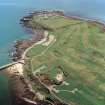
Aberdeen, Torry Battery


Coastal Battery (First World War), Coastal Battery (20th Century), Coastal Battery (Second World War), Coastal Battery (19th Century)
Site Name Aberdeen, Torry Battery
Classification Coastal Battery (First World War), Coastal Battery (20th Century), Coastal Battery (Second World War), Coastal Battery (19th Century)
Alternative Name(s) Torry Point; Aberdeen Harbour, Old South Breakwater; Girdle Ness; Balnagask
Canmore ID 80762
Site Number NJ90NE 22
NGR NJ 96527 05627
NGR Description Centred NJ 96527 05627
Datum OSGB36 - NGR
Permalink http://canmore.org.uk/site/80762


- Council Aberdeen, City Of
- Parish Aberdeen
- Former Region Grampian
- Former District City Of Aberdeen
- Former County Aberdeenshire
In its original form, the Torry Point Battery, is shown on War Department plans from the 1860s (The National Archives WO 78/ 5198) and is as described by RCAHMS.
Emplacements for nine guns - six 68-pdr smooth bore and three larger 10-inch guns - are marked on a plan of 1865 (The National Archives WO 78/5198) which also notes the cost of construction, at £8160 (£609,000 at current value in 2013).
The battery was reconstructed between September 1904 and January 1906 (The National Archives WO 78/5198) at a cost of around £5600 (2013 value £469,000) by an Ayr firm, J & B Meikl. The battery of two 6-inch guns, with a magazine below, lay upon a mound that covered the front wall of the original fort. In the years immediately following the battery was altered, including extending the arc of fire of both guns, to west and east, to cover part of Aberdeen harbour and Nigg Bay; this was done by demolishing parts of earlier gun platforms.
Plans were made in 1913 for the infantry defence of the battery, including the construction of a barbed wire entanglement and a pillbox, which continued in use through the Second World War.
In the Second World War the gun emplacements were given overhead protection against aerial attack and a high battery control tower (visible on post-war aerial photographs) was built.
Information from HS/RCAHMS World War One Audit Project (GJB) 15 July 2013.
Field Visit (28 July 1992)
The Torry Point Battery was built on an earlier 19th century fort and used in the First World War. During WWI the armament consisted of a pair of 6 inch Mk VII/II guns which were removed in 1934. This calibre and mark of gun was returned to the Battery in 1940 during the Second World War and not removed until 1956. The Battery has been demolished, but parts of it may still remain buried at this site.
Visited by Mr J Guy, 28 July 1992.
J Guy 1992; NMRS MS/712/8 and MS/810/1; WO/192/257 PRO; Royal Artillery Libarary, Woolwich.
External Reference (March 1993)
Military fort: visible on air photographs AAS/93/15/G30/7-9 (copies held by Grampian Regional Council).
Information from: Mrs M Greig, Grampian Regional Council, March 1993.
Desk Based Assessment (November 1997)
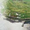
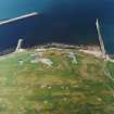
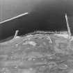
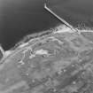
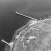
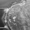
The Torry Point Battery is visible on oblique aerial photographs (RAF [FFO] CPE/Scot/UK/214, 0131-2, flown 1947). The original fort can be seen clearly on the photographs. Also visible are the 6-inch guns still mounted in their WWI emplacements with the large observation tower immediately to the rear. A small accommodation camp consisting of eleven Nissen huts can also be seen to the rear. One pillbox (NJ90NE 22.01) and one searchlight platform are also visible.
Information from RCAHMS (DE) November 1997
Field Visit (10 October 2001)
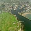
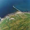
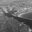
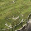
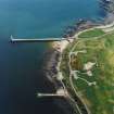
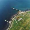
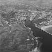
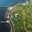
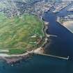
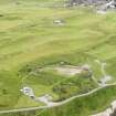
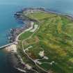
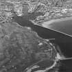
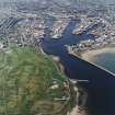
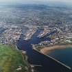
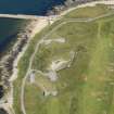
The Torry Point Battery, built in the early 1860s and used again in both the First and Second World Wars, is situated on the N side of Torry Point, a narrow headland overlooking the southern approaches to the mouth of the River Dee and Aberdeen Harbour. The last armaments were removed from the battery in 1956, and the later emplacements have been demolished or buried under roughly landscaped spoil.
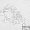
In its original form, the battery was roughly diamond-shaped on plan, but with rounded angles on the NW and SE, and a bastion on the SSW; a second bastion and the adjacent curtain wall on the NNE have been demolished. The high curtain wall of rectangular granite blocks was fronted by a broad ditch, which still survives on the E, S and NW sectors. The interior measures 120m from NW to SE by about 60m, and the main entrance is immediately S of the NW angle, where a rounded arch of finely-dressed ashlar allows vehicular access. Major ranges of buildings stood along the SSW side of the interior, but with the exception of the guardhouse on the N side of the entrance, these have been demolished. The NE sector, where the majority of the nine gun platforms lay has also suffered heavily, first with the construction of large concrete emplacements for the later batteries, and then with their subsequent demolition and landscaping. Nevertheless, elements of three earlier gun platforms are visible at the NW end and at least one at the SE end, and some of the adjacent magazines are also apparently intact, though largely inaccessible. When the battery was operational in the Second World War, there was an extensive encampment of nissen huts outside the curtain wall on the S and SW. These too have been removed, although platforms and concrete floors reveal the presence of most of those on the S. The rest have been destroyed, but aerial photographs and War Department plans show their rough positions.
Visited by RCAHMS (JRS), 10 October 2001.
External Reference (2003)
Torry Point Battery was built to defend the city (NJ90NW 201) and harbour (NJ90NE 7.00) of Aberdeen, replacing a number of older structures. These included a blockhouse (NJ90NE 19) of the 1490's, which was rebuilt on several occasions, and a new battery (NJ90NE 211) which was built on the beach in the 1780's. This latter structure soon fell into disrepair, and was the subject of prolonged negotiations between the City Council and the Board of Ordnance between 1806 and 1860.
In 1858 agreement was reached to build coastal batteries on the beach (NJ90NE 90) and on Torry Point, in part against the background of the perceived threat of Napoleon III of France. Construction of the Torry Point Battery began in 1859 and was completed in March 1861. It was to be manned by a unit of the new volunteer defence forces, the 1st Aberdeenshire Royal Garrison Artillery (Volunteers) being formed for the purpose on 24 October 1860. The battery was initially armed with nine heavy guns (six 68-pounders and three 10-inch shell guns) but in September 1861 two 200-pound Armstrong guns (the heaviest of the day) were added. Drill formally began the same month.
In 1895 the battery was partially dismantled, the guns and mountings being returned to store in Leith. The battery remained in use for volunteer training until 1904 when it was reconstructed, two new 6-inch mark VII guns on CP mark II mountings being installed. This work took two years, at a cost of £5640. The battery was permanently occupied during both world wars, and retained its guns throughout the interwar period, when it was also used as temporary accommodation during periods of housing shortage.
During the Second World War, the battery was manned by army and Home Guard personnel of various units. The guns were given concrete overhead protection against air attack, while anti-aircraft gins and searchlights were also installed, while a combined military and naval plotting room was constructed in 1943. The heavy guns were used just once, against two vessels later found to be friendly, on the night of 3 June 1941, while the machine guns of the battery engaged an enemy aircraft later in the same year.
Between 1945 and 1953, the battery was again used as temporary accommodation. The guns were removed in 1956 and the battery fell into disrepair. Demolition was proposed, as was conversion into a hotel, but neither scheme was implemented. Comprehensive renovation works were carried out in the early 1970's, a car park being laid out and the retaining walls reinstated. The battery and surrounding area are of considerable ornithological interest.
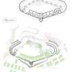
(Numerous illustrations, including site plan and location plan, showing location of predecessor fortifications).
[Aberdeen City Council 2003].
Excavation (2004)
NJ 964 056 Following a project to record this structure in detail, four trenches were excavated to determine how much of the structure remained underground. Just inside the gate, a trench revealed that the foundations for the store buildings, used as housing for homeless families in the 1930s-50s, were well preserved. Theses buildings included a utensil store, 3.5m x 2m, a bedding store with fire place, 4.1m x 2m and ash and coal stores. Trenches in the area of the hospital and the gun emplacements showed that large parts of those structures had been completely removed following demolition. Over 1000 people visited during the excavation: many took an organised tour whilst others tried their hand at excavation during an open day.
Sponsor: Nortrail - The North Sea Trail.
A Cameron 2004.
Project (March 2013 - September 2013)
A project to characterise the quantity and quality of the Scottish resource of known surviving remains of the First World War. Carried out in partnership between Historic Scotland and RCAHMS.
Archaeological Evaluation (5 December 2018)
Four trenches were excavated on 5 December 2018, following two test pits in October 2018. Trenches 3-6 were positioned to excavate the areas of foundations for the proposed temporary viewing and interpretation platform, decked access walkway and outside seating. The remains of the curtain wall were uncovered in each trench with evidence of 3 gun slits. The wall is constructed of granite rubble with cream mortar and was 0.6m wide.
Information from camerona1-343862 (A Cameron) 2018
Note
NJ90NE 22.00 centred 96527 05627
NJ90NE 22.01 NJ 9653 0568 Pillbox
NJ90NE 22.02 NJ 96756 05702 Searchlight
NJ90NE 22.03 NJ 96509 05727 Searchlight
Not to be confused with coast defence battery on Girdle Ness (NJ 969 052), for which see NJ90NE 26.
For possible demolition deposit, see also NJ90NE 111.
See also:
NJ90NE 19 NJ 9570 0578 Pocra Quay, Blockhouse
NJ90NE 26 NJ 969 052 Girdle Ness, Battery
NJ90NE 90 NJ 9541 0658 Queen's Links, Battery
NJ90NE 211 NJ c. 9577 0594 Footdee, Battery

