
Pricing Change
New pricing for orders of material from this site will come into place shortly. Charges for supply of digital images, digitisation on demand, prints and licensing will be altered.
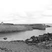
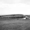
Knock Head, Harbour


Harbour (Post Medieval)
Site Name Knock Head, Harbour
Classification Harbour (Post Medieval)
Alternative Name(s) Whitehills; Boyndie Bay; Blackpots Harbour; Blackpotts Haven
Canmore ID 133063
Site Number NJ66NE 4
NGR NJ 6596 6588
Datum OSGB36 - NGR
Permalink http://canmore.org.uk/site/133063


- Council Aberdeenshire
- Parish Boyndie
- Former Region Grampian
- Former District Banff And Buchan
- Former County Banffshire
NJ66NE 4 6596 6588
Not to be confused with Whitehills harbour (NJ 655 657), for which see NJ66NE 2.00.
Harbour (dis) [NAT]
OS 1:10,000 map, 1977.
(Location cited as NJ 659 659). Harbour, Blackpots, late 18th century. Firmed by a rubble pier, with a sea wall, and a pier, also rubble.
J R Hume 1977.
Air photographs: AAS/97/12/G26/21 and 23, and AAS/97/12/CT.
NMRS, MS/712/29.
Field Visit (September 2022)
Visited during fieldwork by SCAPE. No changes to description. There is a cleared slipway on the east side of the harbour entrance leading to a landing beach.
Information from S. Boyd and J. Hambly - Scottish Coastal Archaeology and the Problem of Erosion (SCAPE).

