
Pricing Change
New pricing for orders of material from this site will come into place shortly. Charges for supply of digital images, digitisation on demand, prints and licensing will be altered.
Mortlich


Commemorative Monument (Period Unassigned), Fort (Period Unassigned)
Site Name Mortlich
Classification Commemorative Monument (Period Unassigned), Fort (Period Unassigned)
Alternative Name(s) Aboyne
Canmore ID 17515
Site Number NJ50SW 6
NGR NJ 5356 0173
Datum OSGB36 - NGR
Permalink http://canmore.org.uk/site/17515


- Council Aberdeenshire
- Parish Coull
- Former Region Grampian
- Former District Kincardine And Deeside
- Former County Aberdeenshire
NJ50SW 6 5356 0173.
(NJ 5356 0173) Fort (NR)
OS 6" map, (1959)
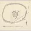
The remains of this fort occupy the termination of an isolated ridge from which the entire length of upper and middle Strathdee can be observed from a height of 1248 ft (380m) above sea level and 800ft (244m) above the river at Aboyne. It consists of a ruined wall enclosing an area measuring 200ft (61m) by 145ft (44m). It has been robbed partly to build field boundaries and partly, no doubt, to build the large modern cairn which occupies the exact summit of the hill within the fort; this was surmounted by a cemented cone of stones in which a heavy cross of cast iron was implanted. The whole has been cast down, presumably by natural forces and lying among the ruin is a slab inscribed 'CHARLES 10TH MARQUIS OF HUNTLY/ DIED 18TH SEPTEMBER 1863./ ERECTED BY MARY ANTOINETTA HIS WIDOW AND THE TENANTRY OF ABOYNE'.
R W Feachem 1963.
Only a few loose stones remain of the dyke of this circular camp.
Name Book 1870.
There is a small isolated cairn, possibly a boundary marker, on top of a ridge 200yds to the N.
A Ogston 1931.
Generally as described by Feachem (1963), little remains of this fort, save for a slight bank visible as a heather covered rickle of stone, 0.3m maximum height, which encloses the flattish summit of Mortlich. No wall faces or entrances are discernible. The large modern cairn mentioned by Feachem (1931) is a tumbled obelisk to the memory of the Marquis of Huntly. The 'cairn' to the N appears to be natural rock outcrop.
Surveyed at 1/2500.
Visited by OS (NKB) 25 October 1968.
Field Visit (15 August 1956)
This site was included within the RCAHMS Marginal Land Survey (1950-1962), an unpublished rescue project. Site descriptions, organised by county, are available to view online - see the searchable PDF in 'Digital Items'. These vary from short notes, to lengthy and full descriptions. Contemporary plane-table surveys and inked drawings, where available, can be viewed online in most cases - see 'Digital Images'. The original typecripts, notebooks and drawings can also be viewed in the RCAHMS search room.
Information from RCAHMS (GFG) 19 July 2013.
Note (10 April 2015 - 18 May 2016)
A heavily robbed enclosure on the summit of Mortlich is probably the remains of a small fortification occupying a position from which there are commanding views up and down Strath Dee. Oval on plan, it measures about 62m from ENE to WSW by 45m transversely (0.21ha) within a wall reduced to a heather-grown band of stones 3m thick and no more than 0.3m high; traces of a gap on the ENE possibly indicate the position of the entrance. The interior is featureless, much of the eastern half being a quarried outcrop surmounted by a cairn erected in 1863 in commemoration of the 10th Marquis of Huntly.
Information from An Atlas of Hillforts of Great Britain and Ireland – 18 May 2016. Atlas of Hillforts SC2948

