
Scheduled Maintenance
Please be advised that this website will undergo scheduled maintenance on the following dates: •
Tuesday 3rd December 11:00-15:00
During these times, some services may be temporarily unavailable. We apologise for any inconvenience this may cause.
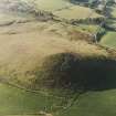
Wheedlemont


Fort (Iron Age)
Site Name Wheedlemont
Classification Fort (Iron Age)
Alternative Name(s) Cnoc Cailliche; Wheedlemont Hill
Canmore ID 17215
Site Number NJ42NE 5
NGR NJ 47289 26069
Datum OSGB36 - NGR
Permalink http://canmore.org.uk/site/17215


- Council Aberdeenshire
- Parish Auchindoir And Kearn
- Former Region Grampian
- Former District Gordon
- Former County Aberdeenshire
NJ42NE 5 4729 2605.
(NJ 4729 2605) Cnoc Cailliche (NAT) Camp (NR)
OS 6" map, Aberdeenshire, 2nd ed., (1902)
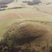
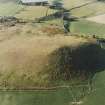
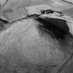
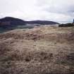
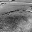
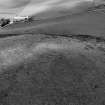
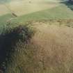
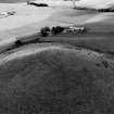
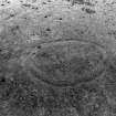
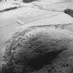
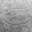
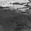
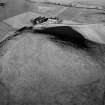
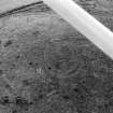
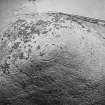
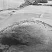
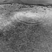
Cnoc Cailliche - the old wifes' or witches' hill. It has an oval enclosure on its summit, accepted as an Iron Age hill fort by Simpson (1932). It measures 60 yards N-S by 31 yards and is formed by a ditch, 13 feet wide and 3 feet deep, with traces of an earthen bank on the inside and a slight counterscarp bank on the outside. The inside area is stony with no evidence of structures (Simpson 1930). The Ordnance Survey Name Book (ONB, 1867) refers to local supposition that there was a wooden palisade on the bank. Jervise (1871) describes it as an elliptical entrenchment enclosing about 100 acres. On the S and W sides, which are easiest of access, a ditch surrounds the base. The remains of a dyke upon the north is said to have stretched, at one time, to the Hill of Noth (NJ 48 29).
Name Book 1867; A Jervise 1871; W D Simpson 1930; W D Simpson 1932.
A small fort, generally as described by Simpson, except that the inner bank is primarily of stones, not earth. Both inner and outer ramparts are greatly reduced. The entrance, c.3.0m wide, is in the NE. The 'entrenchment enclosing about 100 acres' mentioned by Jervise, clearly is not the fort but possibly refers to an old field wall which skirts the base of the hill.
Revised at 1/2500.
Visited by OS (NKB) 28 September 1967.
An Iron Age sherd from this fort is in the Royal Museum of Scotland (RMS, formerly the National Museum of Antiquities of Scotland [NMAS]).
Proc Soc Antiq Scot 1974.
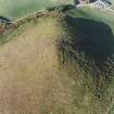
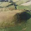
This oval enclosure, which crowns a shoulder of the rounded, 352m OD hill near the top of Strathbogie, is typical of the simple later prehistoric forts of Grampian. It consists of a shallow ditch (4m wide and 1m deep) with a stony bank on its inner edge and a slight bank on the outer edge. The subdued defences and the dead ground surrounding the fort (especially to N and E) suggest that defence was not an overwhelming priority for the builders.
I A G Shepherd 1986.
(Visible on air photographs AAS/93/01/G2/1-4. Copies held by Grampian Regional Council).
Information from M Greig, Grampian Regional Council, March 1994.
(Air photographs listed).
NMRS, MS/712/47.
(Air photographs: AAS/00/02/G3/15 and AAS/00/02/CT).
NMRS, MS/712/100.
Scheduled as 'Cnoc Cailliche, fort 360m WSW of Upper Wheedlemont... visible as an upstanding earthwork and ditch, situated in rough pasture on the summit of a cone-shaped hill...'
Information from Historic Scotland, scheduling document dated 7 November 2007.
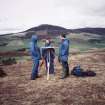
Field Visit (3 August 1956)
This site was included within the RCAHMS Marginal Land Survey (1950-1962), an unpublished rescue project. Site descriptions, organised by county, are available to view online - see the searchable PDF in 'Digital Items'. These vary from short notes, to lengthy and full descriptions. Contemporary plane-table surveys and inked drawings, where available, can be viewed online in most cases - see 'Digital Images'. The original typecripts, notebooks and drawings can also be viewed in the RCAHMS search room.
Information from RCAHMS (GFG) 19 July 2013.
Publication Account (1986)
This oval enclosure, which crowns a shoulder of the rounded, 352m OD hill near the top of Strathbogie, is typical of the simple later prehistoric forts of Grampian. It consists of a shallow ditch, 4m wide and 1m deep, with a stony bank on its inner edge and a slight bank on the outer edge. The entrance is at the north-eastern end. The subdued defences and the dead ground surrounding the fort, especially to north and east, suggest that defence was not an overwhelming priority for the builders.
Information from ‘Exploring Scotland’s Heritage: Grampian’, (1986).
Field Visit (24 April 1996)
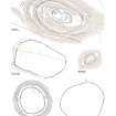
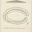
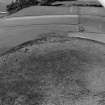
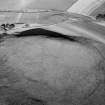
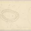
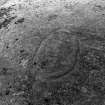
The fort on the summit of the Cnoc Cailliche, or Wheedlemont Hill, is oval on plan and measures 50m from NE to SW by 27m transversely within a stone wall now reduced to little more than a thick band of grass-grown rubble. The wall stands inside a ditch up to 4m broad by 1m deep with a low counterscarp bank; the entrance is on the NE. A shallow quarry flanks the inner edge of the wall and a row of at least three timber round-houses is set along the spine of the interior.
Visited by RCAHMS (ARG, JRS, AL) 24 April 1996.
Measured Survey (24 April 1996)
RCAHMS undertook a measured survey of the fort at Wheedlemont Hill using a self-reducing alidade and plane-table on 24 April 1996. The resultant 1:500 plan was redrawn in ink, scanned and finalised in graphic vector software and subsequently published at 1:1250 (RCAHMS 2007, fig. 6.25).
Publication Account (1996)
This oval enclosure, which crowns a shoulder of the rounded, 352m OD hill near the top of Strathbogie, is typical of the simple later prehistoric forts of Grampian. It consists of a sha llow ditch, 4m wide and 1m deep, with a stony bank on its inner edge and a slight bank on the outer edge. The entrance is at the north-eastern end. The subdued defences and the dead ground surrounding the fort, especially to north and east, suggest that defence was not an overwhelming priority for the builders.
Information from ‘Exploring Scotland’s Heritage: Aberdeen and North-East Scotland’, (1996).
Note (6 April 2015 - 16 August 2016)
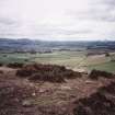
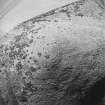
This small fortification occupies the summit of a conical hill forming the eastern end of a ridge WSW of Rhynie above Wheedlemont. Oval on plan, it measures about 50m from NE to SW by 30m transversely (0.11ha) within a wall reduced to low band of rubble on the inner lip of a ditch with a counterscarp bank; the ditch measures up to 4m in breadth by 1m in depth. Traces of a continuous internal quarry can be traced to the rear of the wall around the whole circuit, while set along the spine of the interior there is a row of at least three timber round-houses. The entrance is on the NE.
Information from An Atlas of Hillforts of Great Britain and Ireland – 16 August 2016. Atlas of Hillforts SC2939
Excavation (August 2017 - September 2017)
NJ 4729 2605 Wheedlemont is a small oval enclosure classified as a fort located a few miles SW of the village of Rhynie. Very little is known of such small enclosed sites in the region, including how they may relate to other
settlements from the Iron Age or early medieval periods.
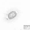
Investigations at Wheedlemont have been restricted to visits and basic descriptions of the site from the late 19th century and 1930s, as well as a survey in 1956 and descriptive account in 1986 by RCAHMS. This has resulted in the identification of the site as a small fort with two ramparts, or banks, with a ditch in between, a possible entrance to the E, but no visible internal structures. A recent LiDAR survey also seems to point towards the absence of internal structures. The site was scheduled in 2007. A two week evaluation, during late August and early September 2017, was carried out to provide basic chronology and characterisation of the inner and outer ramparts/banks, the ditch and entrance way, as well as testing the presence of internal structures and features, as part of the Leverhulme funded Comparative Kingship project.
Three trenches were laid out. Trench 1 was laid over the inner rampart/bank, ditch and outer rampart/bank on the W side of the hillfort. Internal to the ditch, a stone-built wall, c1m wide consisting of a single course of stones and a possible shallow foundation trench, was identified
along with a counterscarp bank on the outside of the ditch. An earlier wall, probably made of stone and turf, possibly flanked by posts, was also identified and located approximately in the same location. The ditch itself was c2.5m wide and c0.5m deep. Trench 2 was located on a possible platform in the western part of the enclosed area. No interior structures were identified but putative cut features as well as charcoal rich deposits, possibly representing a floor and hearth, were uncovered. Trench 3 was located in the area believed to be the entrance to the fort, on its E side, where there is a break in the enclosure. The northern ditch terminal was identified and was c2m wide and c0.75m deep but there was no structural evidence of an entrance. No finds were recovered from the excavation
trenches. Radiocarbon dating will clarify the chronology of the two ramparts, the enclosing ditch and possible internal features in Trench 2.
Archive: University of Aberdeen
Funder: University of Aberdeen and Leverhulme Trust
Gordon Noble and Edouard Masson-Maclean – University of Aberdeen
(Source: DES, Volume 18)

