
Dalrossach Hill


Cairn (Later Prehistoric)(Possible), Kerb Cairn (Later Prehistoric)(Possible)
Site Name Dalrossach Hill
Classification Cairn (Later Prehistoric)(Possible), Kerb Cairn (Later Prehistoric)(Possible)
Canmore ID 75287
Site Number NJ41SW 36
NGR NJ 4148 1479
Datum OSGB36 - NGR
Permalink http://canmore.org.uk/site/75287


- Council Aberdeenshire
- Parish Towie
- Former Region Grampian
- Former District Gordon
- Former County Aberdeenshire
NJ41SW 36 4148 1479
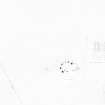
A stone circle, 6m in diameter, comprising seven stones standing to a maximum height of 0.4m, and a gap for a possible eighth was discovered on the N edge of the revetting wall that is noted under NJ41SW 38.04.
Visited by CFA, October 1992.
CFA 1993n; MS/625/32.
This monument is situated on a moderate SE-facing slope in an area of rough grazing at an altitude of 320m OD.
NMRS, MS/712/46.
Project (October 1992)
Pre-afforestation survey undertaken at Dalrossach Hill, Gordon, Grampian.
T Neighbour 1992.
Field Visit (28 April 1997)
NJ41SW 36 4148 1479
(Reclassified as kerb-cairn (possible) and field clearance cairn). What may be the remains of a kerb-cairn, previously described as a stone circle, are situated on a narrow terrace on the SE flank of Dalrossach Hill. It comprises as many as nine boulders, the largest measuring 0.6m in diameter and 0.5m in height, and has an overall diameter of 5.4m.
The subrectangular clearance cairn immediately to the W is almost certainly of modern origin.
Visited by RCAHMS (JRS, ATW), 28 April 1997.
Measured Survey (13 October 1998)
RCAHMS undertook measured survey of the cairn at Dalrossach Hill on 13 October 1998 using plane-table and alidade. The 1:100 plan was scanned, redrawn in graphic vector software and published at 1:500 (RCAHMS 2007, fig. 5.8)

