
Innes Links, Emergency Coast Battery


Coastal Battery (Second World War)
Site Name Innes Links, Emergency Coast Battery
Classification Coastal Battery (Second World War)
Alternative Name(s) Spey Bay Anti-invasion Beach Defences
Canmore ID 293091
Site Number NJ26NE 30
NGR NJ 2813 6789
NGR Description Centred NJ 2813 6789
Datum OSGB36 - NGR
Permalink http://canmore.org.uk/site/293091


- Council Moray
- Parish Urquhart
- Former Region Grampian
- Former District Moray
- Former County Morayshire
NJ26NE 30.00 centred 2813 6789
For coast defences at Innes Links see NJ26NE 14.00 and NJ36NW 5.00
NJ26NE 30.01 NJ 28148 67892 Gun Emplacement (No.1 gun)
NJ26NE 30.02 NJ 28102 67910 Gun Emplacement (No.2 gun)
NJ26NE 30.03 NJ 28238 67849 Observation Post (Battery OP)
NJ26NE 30.04 NJ 28315 67817 Searchlight Emplacement (E)
NJ26NE 30.05 NJ 27993 67962 Searchlight Emplacement (W)
NJ26NE 30.06 NJ 28141 67836 Engine House (Main)
NJ26NE 30.07 NJ 28237 67802 Engine House (E)
NJ26NE 30.08 NJ 27981 67940 Engine House (W)
NJ26NE 30.09 NJ 28106 67865 Magazine; Trench
NJ26NE 30.10 NJ 28088 67773 (centred) Military Camp (accommodation)
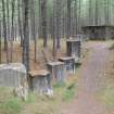
This Second World War concrete built coast battery situated on the seaward side of a fishing station, consisted of two 6 inch gun emplacements, three engine rooms and two searchlight platforms.
There are two boltrings in each emplacement with camouflage paint and wires still extant. The guns were placed on a care and maintainance basis in April 1945 and removed later that year.
J Guy 1992; NMRS MS 810/1 1992; Royal Artillery Library, Woolwich.
GRC NJ26NE 15 2815 6785. Coastal battery comprising 2 x 6 in. gun emplacements, 3 x engine rooms and 2 x searchlight emplacements set facing N across foreshore (NJ24NE 14.14). The battery formed at Lossiemouth on 28 May 1941; it had been reduced to care and maintenance by April 1945 and removed by June 1945.
Defence line of anti-tank blocks and pillboxes protecting the dunes.
Visited by J Guy
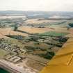
This battery and defence line is visible on Royal Air Force vertical aerial photographs taken in 1945 (106G/UK 750: 5008, 5009) and oblique aerial photographs taken in 1950 (541/A/487: 0077-0078).
Information from RCAHMS (KM) 13 March 2001.
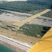
The emergency coast battery comprises two brick and concrete gun emplacements located at NJ 28102 67910 and NJ 28148 67892, and situated on the slope of the first line of sand dunes immediately to the rear of the anti-tank and pillbox line. The associated huts and buildings are situated to the S, E and W of the gun-emplacements (see NJ26NE 30.03-30.10) most of which are depicted on the current OS 1:2500 scale digital map.
The battery is notable for its relative completeness including a connecting trench or sunken path system (NJ26NE 30.09) cut into the sand dunes leading from the gun emplacements (NJ26NE30.01 and 30.02) to the magazine (NJ26NE 30.09) and beyond. The gun emplacements unusually have two holdfast boltrings in each, one set to the side of the gun platform, but no explanation for this has yet been found.
The accommodation camp for gun crews comprising several concrete hut bases is situated about 130m to the S, immediately N of the Fishing Station (NJ26NE 31).
Two 6-inch MkXI/V were recorded as mounted at the Battery in May 1941 with the installation reduced to care and maintenance by April 1945, the guns being removed in June 1946. The 227 Battery was formed at Lossiemouth (Royal Artillery Library at Woolwich; J Guy 1992).
Visited by RCAHMS (DE, NG), 27 February 2008
Publication Account (2009)
The website text produced for Lossie World War II defences webpages on the Forest Heritage Scotland website (www.forestheritagescotland.com).
Introduction: Defending the coast
During World War II, the construction of a line of defences along the Moray coastline aimed to slow down a possible German invasion. Today, in Lossie Forest, you can explore the remains of these defences.
In 1940, Britain was under threat of German invasion]. As a result, a plan was put into action to defend any coastline where the enemy could easily land.
The Moray coastal defences ran between Cullen Bay and Findhorn Bay, through today's Lossie and Roseisle Forests].
Within Lossie Forest, you will discover evidence of the variety of defences constructed. Firstly, there are the concrete foundations of a military camp. This is where the soldiers who constructed and manned the defences lived.
Concrete anti-tank blocks ran the full length of the defences. They are no longer complete but long sections of the line are still visible on the edge of the forest.
Pillboxes were another part of the defences. Two alternating designs, square and hexagonal shaped, zigzagged a line along the coastline. Over twenty of these still remain at Lossie.
On the edge of the forest, you will discover the ruins of a Coastal Battery, consisting of a number of structures. The long range guns stationed at the battery protected Lossiemouth port from attack by sea.
Discover how the coastal battery operated in our "People" story.
People Story: Running a coastal battery
Now derelict, the coastal battery at Lossie Forest defended Lossiemouth harbour from German attack during World War II.
In June 1940, a Polish Army Engineer Corps constructed some of these defences. Wieslaw Szczygiel, a Polish soldier in that unit, recalls briefly working on them before moving to a unit at Tentsmuir.
The 227th battery of the 501 Coastal Regiment manned the coastal station once it was completed on the 28th of May 1941.
At the front of the battery were two gun emplacements, armed with large 6 inch Mark 11 guns. These were old World War I guns removed from naval ships and stored until needed. They were powerful and could fire long distances, excellent for keeping enemy ships at bay.
Behind the gun emplacements, there were a series of other buildings. Two machine gun emplacements would provide firepower to defend the beach if enemy troops landed.
A vital building was the Battery Observation Post (BOP). As command control, this was where the calculations for aiming and firing the big guns were made. Later, radar was introduced to help detect the enemy's approach.
Two searchlight stations provided light to see an enemy attack at night.
To prevent detection from enemy planes the buildings were painted and hidden with web netting. Today this camouflage is no longer evident.
In April 1945, the battery went out of operation followed by the removal of the guns two months later.
Evidence Story: Using laser technology to interpret the past
In 2009, AOC Archaeology undertook a survey of the World War II remains in Lossie Forest. This record will help Forestry Commission Scotland manage the site. It also provides new opportunities for presenting the site to the public.
A key element of this survey was the recording of the western gun emplacement of the coastal battery, located on the beach.
AOC Archaeology used a laser scanner to record the structure and create a detailed 3-dimensional digital reconstruction of the building. You can view the results as an animation - the powerful laser scanner has even picked up the modern graffiti.
This technique is a relatively new way of recording archaeological remains and historic buildings. The laser scanner shoots laser rays at different points inside and outside the building. It records the distance from the scanner to each point. This information is collected as digital data points, called point-clouds.
Using the point-clouds, the building's shape is accurately recreated, as you can see in our animation. This information also created 2-dimensional plans and elevations of the building, similar to architectural plans.
This digital information forms the basis for a series of reconstruction paintings of how the gun emplacement looked in World War II. The artist, Drew Smith, selected his view point and accurately scaled his drawings.
Flick through the images and see the artistic process of converting the digital information into a final, watercolour reconstruction of the gun emplacements.

