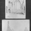
Drainie, Old Parish Church
Burial Ground (Post Medieval), Church (Post Medieval)
Site Name Drainie, Old Parish Church
Classification Burial Ground (Post Medieval), Church (Post Medieval)
Alternative Name(s) Raf Lossiemouth; Lossiemouth Airfield; Little Drainie Church; Burial Ground
Canmore ID 16120
Site Number NJ16NE 17
NGR NJ 19957 69215
Datum OSGB36 - NGR
Permalink http://canmore.org.uk/site/16120
- Council Moray
- Parish Drainie
- Former Region Grampian
- Former District Moray
- Former County Morayshire
NJ16NE 17 1995 6821
(NJ 1995 6921) Church (NR) (In Ruins)
OS 6" map, (1938)
For Drainie (New) Kirk, see NJ26NW 88.
For (surrounding) Lossiemouth Airfield (RAF Lossiemouth), see NJ26NW 50.00.
Built between 1654 and 1675 (R G Cant 1948) the church of Drainie is 62 feet long by 24 feet wide; in the centre of the north side is a wing, spanned by an arch, 24 feet by 18 feet (MacGibbon and Ross 1896-7).
D MacGibbon and T Ross 1896-7; R G Cant 1948.
A severe storm in the winter of 1952 is reported to have blown down the belfry and most of the E gable. The Admiralty subsequently demolished the remainder, reducing it to a dwarf wall.
Scott H et al (eds.), 1915-61.
Access was not obtained to this site which lies within the perimeter of Lossiemouth airfield (RNAS). The airfield authorities state that the church has been entirely demolished, and this was confirmed by local enquiries.
Visited by OS (W D J) 28 November 1962; Information from A J Smith, Farmer, Silverhills and R Murray, Farmer, Sweethillock.
This monument falls within the perimeter of RAF Lossiemouth (Lossiemouth Airfield: NJ26NW 50).
Information from RCAHMS (RJCM), 24 January 1999.
Desk-based surveys were undertaken on several churches in Moray following on the work upon Moray graveyards (Farrell 1997) including:
NJ 1995 6921 The old parish church was demolished in 1952. A study was made of church records, parish registers, local history publications, maps, photographs and churchyard interment records.
Report lodged with the NMRS.
S Farrell 1999
INVENTORY OF GRAVEYARD AND CEMETERY SITES IN SCOTLAND REFERENCE:
Address: N/A
Postcode: IV31 6SB
Status: Closed for burials but maintained
Size: 0.07 hectares, 0.17 acres
Polygon: Yes
TOIDs: 1000000172528545 (church),1000000172528544 (graveyard)
Number of gravestones: 67
Earliest gravestone: 1695
Most recent gravestone: 1908
Description: Graveyard associated with a church (church demolished). The church was abandoned in 1825 and demolished 1952. The church building and graveyard walls are demolished and all tombstones laid flat in the interests of aircraft safety. A mixture of flat stones and upright stones. No significantly important carvings.
Data Sources: Graveyard Recording Form, 30 November2003; OS Mastermap checked 10 June 2005
The burial ground and site of Drainie Old Parish Church is situated in the SW runway section of RAF Lossiemouth Airfield (NJ26NW 50.00), immediately inside the perimeter track and between two large aircraft hangar dispersal areas.
The T-shape of the church is marked out by a low wall in the grass area between the runways as is the adjoining burial ground within which are the graveslabs. All of the graveslabs have been laid flat and the area is well tended with the grass being kept shorter than the surrounding area.
Several of the graveslabs are ornate, but most have only carved inscriptions.
Visited by RCAHMS (DE), 29 August 2007.
Archaeological Evaluation (12 March 2018 - 21 March 2018)
Wessex Archaeology was commissioned by WYG on behalf of the Defence Infrastructure Organisation (DIO), to undertake an archaeological evaluation of the area of land adjacent to the south of the northern taxiway at RAF Lossiemouth, Moray, prior to the widening of the taxiway. The evaluation demonstrated that much of the area has been extensively landscaped during the construction of the airfield in the late 1930s, but that in some areas archaeological deposits of unknown age do exist. These features are generally shallow and truncated by the landscaping. It is probable that they are prehistoric in date, due to their similarities in shape and form as cropmarks with other examples in the area. Areas of low ground were filled in with material scraped and planed from areas of higher ground, as shown in the areas of high natural only 0.15 m below the current ground surface. Immediately prior to this landscaping a series of dumps of modern material were made in the area to the southwest of the old graveyard.
Information from OASIS ID: waherita1-313625 (B Saunders) 2018


