
Pricing Change
New pricing for orders of material from this site will come into place shortly. Charges for supply of digital images, digitisation on demand, prints and licensing will be altered.
Upcoming Maintenance
Please be advised that this website will undergo scheduled maintenance on the following dates:
Thursday, 9 January: 11:00 AM - 3:00 PM
Thursday, 23 January: 11:00 AM - 3:00 PM
Thursday, 30 January: 11:00 AM - 3:00 PM
During these times, some functionality such as image purchasing may be temporarily unavailable. We apologise for any inconvenience this may cause.
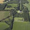
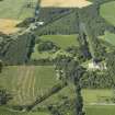
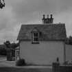
Brodie Castle, Station Lodge And Gate Piers


Gate Pier(S) (19th Century) (1840), Lodge (19th Century) (1840)
Site Name Brodie Castle, Station Lodge And Gate Piers
Classification Gate Pier(S) (19th Century) (1840), Lodge (19th Century) (1840)
Alternative Name(s) Brodie Castle Policies
Canmore ID 171455
Site Number NH95NE 10.03
NGR NH 97842 57262
Datum OSGB36 - NGR
Permalink http://canmore.org.uk/site/171455


- Council Moray
- Parish Dyke And Moy
- Former Region Grampian
- Former District Moray
- Former County Morayshire
Field Visit (September 2013 - April 2014)
Two-storey, asymmetrical gabled gate lodge on north-west side of Station gate; harled with tooled ashlar margins, built about 1840. South-east 2-bay front to driveway with advanced gable fronted by projecting canted ground floor window and with lean-to porch in re-entrant angle with diagonal stepped buttressing. Gabled dormer breaks wallhead; slate roof with projecting eaves. Lean-to additions at rear.
Shown as West Lodge on the 1870 1st edition OS 1:2500 and 1:10560 maps, and as Station Lodge on later maps.
(BRD14 B33)
The gateway comprises a pair of square rusticated ashlar gatepiers with stepped cope supporting tall urn finials; a matching third pier (no urn) is positioned approx 5m to the south-east separated by beech hedge (off line on west); the equivalent piers on the north, close to the lodge, has been reduced in height and a section of the cap is missing (on grass on south of drive). No gates survive. Dressed stone and coped walls approx 1.2m high walls curve round to the Dyke road at the south-east and in a straight to Kennel Road to south-west, here terminated by a lower pier. On the opposite side of the road is a fragment of old wall (cut by the railway fence line) and a pier of the same style, remnants of the pre-railway and pre-lodge layout at the end of Kennel Road shown on the 1770 Brown plan.
(BRD14 B34)
Information from NTS (SCS) February 2016

