
Pricing Change
New pricing for orders of material from this site will come into place shortly. Charges for supply of digital images, digitisation on demand, prints and licensing will be altered.
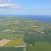
Cullisse, "chapel Park"


Chapel (Medieval) - (Post Medieval)(Possible)
Site Name Cullisse, "chapel Park"
Classification Chapel (Medieval) - (Post Medieval)(Possible)
Alternative Name(s) Culiss
Canmore ID 15268
Site Number NH87NW 3
NGR NH 828 752
NGR Description NH c.828 725
Datum OSGB36 - NGR
Permalink http://canmore.org.uk/site/15268


- Council Highland
- Parish Nigg (Ross And Cromarty)
- Former Region Highland
- Former District Ross And Cromarty
- Former County Ross And Cromarty
NH87NW 3 828 752.
Slight remains of a chapel were visible within a small enclosure called "Chapel Park" at Culiss, during the 18th century.
Orig Parch Scot 1855.
No trace. The name "Chapel Park" is not known locally.
Visited by OS (I S S) 29 August 1972.
A large range of buildings on the N side of the property including a smith and water supply approaching from the SE and leaving to the N. A house is in the centre of almost circular grounds of gardens and woodland. A walled garden to the SW side and a circular summer house on the SE edge. (Information from HSMR)
A smithy is marked on the farm of Culisse on the 2nd edition map of 1907
Field Visit (September 1977)
Cullisse, Chapel NH c.828 752 NH87NW 3
The remains of a chapel were recorded in 'Chapel Park' in the 18th century.
RCAHMS 1979, visited September 1977
(OPS 1851-5, ii, 454)

