
Pricing Change
New pricing for orders of material from this site will come into place shortly. Charges for supply of digital images, digitisation on demand, prints and licensing will be altered.
North Sutor, Coast Battery


Engine House (First World War), Searchlight Battery (First World War), Searchlight Battery (Second World War)
Site Name North Sutor, Coast Battery
Classification Engine House (First World War), Searchlight Battery (First World War), Searchlight Battery (Second World War)
Alternative Name(s) Cromarty Defences; Fort North Sutor, Site No. 1
Canmore ID 170750
Site Number NH86NW 9.05
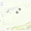
NGR NH 8210 6872
NGR Description NH 8210 6872, NH 8213 6874 and NH 8212 6876
Datum OSGB36 - NGR
Permalink http://canmore.org.uk/site/170750


- Council Highland
- Parish Nigg (Ross And Cromarty)
- Former Region Highland
- Former District Ross And Cromarty
- Former County Ross And Cromarty
NH86NW 9.05 8210 6872, 8213 6874 and 8212 6876
Incorporates information from duplicated site no.NH86NW 9.15
2 connected turrets and a third on an isolated stack. Slowly decaying. Doors and shields rusting and falling off. The connecting bridge is almost collapsed and dangerous.
CFA/MORA Coastal Assessment Survey 1998.
Two searchlight platforms at the foot of the cliff. Not visited.
Information from RCAHMS, October 2004
Note (29 July 2013)
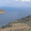
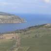
Located on rock stacks at the foot of the cliffs below First and Second World War battery (Site No. 1) are the remains of three searchlight emplacements. The searchlights was accessed via a wooden and stone flight of steps down a very steep slope. Two searchlights lie next to each other separated by a geo which required the building of a small suspension bridge to access the E searchlight. Both were part of the original 1913 plan but were rebuilt for the Second World War to a different design. A plinth possibly for a transformer or other electrical equipment lies to the rear of the W building. A metal wire framework similar in appearance to a rope ladder, which extends across the geo to the cliffs above, once carried the power and communication cables. The remains of a second one can be seen next to the NW corner of the bridge.
A third searchlight dating to the First World War can be seen on a rock stack c.50m to the NE. Below the emplacement on the N side of the stack is a possible landing stage or a stone access path to the rock stack. The emplacement is similar to those on the South Sutor with a low concrete wall and a metal frame for a canvas or wooden roof and walls and a concrete closet to the rear.
On the path to the searchlights, about half way down is a small building, possibly for eletrical equipment.
Information from RCAHMS (AKK) 29 July 2013.
Project (March 2013 - September 2013)
A project to characterise the quantity and quality of the Scottish resource of known surviving remains of the First World War. Carried out in partnership between Historic Scotland and RCAHMS.
Field Visit (29 May 2019)
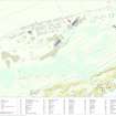
The remains of this searchlight battery, which was originally introduced to the infrastructure of the North Sutor Coastal Battery by the Admiralty in World War I, are situated at the foot of the steep, heather-, gorse- and grass-grown slopes about 105m below the gun emplacements of Site No.1. The battery comprised a ‘Sentry Light’, a ‘Searching Light’ and a ‘Fighting Light’ for the 9.2ins guns housed in the World War I gun emplacements (NH86NW 9.02). However, there is evidence to suggest that this last may not have been part of the original plan (WO78/5192-11/19), which included the two more westerly lights and the suspension bridge that connects them.
The battery is reached by a very steep winding path that was originally supplemented by wooden stairs in its more precipitous stages. However, where rock outcrop begins to emerge in the descent, there are two flights of grass-grown concrete steps. These are reinforced at their outer edge by a crude revetment wall and the sockets for a protective handrail are still visible intermittently.
The Army rebuilt the Sentry Light (NH 82102 68738) and the Searching Light (NH 82128 68748) to a standardised design at the outbreak of WWII, but the Fighting Light (NH 82158 68789) to their ENE was not re-commissioned and still preserves the original character of all three lights. It stands on the summit of a stack that rises about 15m above sea-level and it is now approached from the steps leading down the cliff by crossing the rocks SW of the Sentry Light and entering the mouth of a cave (NH 82084 68733). At its far end this opens into a narrow defile leading out on to the rocky shore N of the stacks. However, the cave is tidal and access would normally have been by a path with wooden stairs branching from the main route and descending via a gully (NH 8207 6877) to the shore below. From here the Fighting Light is reached by a footway running upon a faced rubble mole that hugs the N side of the stack up to 2m above the waterline. The shattered remains of a concrete platform (NH82157 68800), which originally supported a dedicated petrol generator (NH86NW 9.23), are visible close to the shore, but there is no trace of the steps at the SE end of the mole that would have facilitated the climb to the Fighting Light. It now comprises a largely grass-grown concrete platform measuring 7.6m from NW to SE by 3.06m transversely. It is rectangular on plan except on the SE where it is polygonal and supports a five-sided parapet 0.3m thick and 0.69m high. An iron frame measuring 2.9m square still stands on the SW and this, together with more fragmentary remains on the NE, as well as further struts fallen to the ground, originally supported a corrugated iron cladding that extended over the whole of the platform. There is no trace of an entrance, which would have been located in the centre of the NE wall, but there are vestiges of iron shutters in a groove on top of the parapet. These shutters not only closed off the internal operating lights after dark but by drawing them back or forth they could be used to focus the beam by intensifying or diminishing the spread of the light. A small rectangular aperture is situated at the foot of the parapet on the SW and about 2.3m NW of this is a telephone box, measuring 1.2m from NE to SW by 0.9m transversely within cast concrete walls 0.12m thick and 2m high. Although it has a flat roof and a doorway facing NE, the surviving metal frame of the cladding rises above it and it was clearly entirely enclosed within the housing. There are no traces of the bunks that were situated behind the telephone box in the NW part of the building. A single iron post to the S of the platform, together with the concrete foundations of others, indicates that a barbed wire entanglement once surrounded and protected the light.
The solid concrete foundations of the Fighting Light’s two World War I companions still survive below the Army’s later housings. The Sentry Light’s platform (NH 82102 68738), which is rectangular on plan with a polygonal frontage overlooking the firth, measures 6.9m from N to S by 4.2m transversely and up to 1m high. The site of the neighbouring Searching Light (NH 82128 68748) was not visited, but its foundations appear to be of the same size and design. However, the NW to SE orientation of its platform, together with the uneven and broken character of the stack’s rocky summit, necessitated the construction of a short flight of steps, which rounds the N corner of the building to reach an entrance on the NE.
The Admiralty also constructed the suspension bridge (NH 82115 68747) that linked these two lights. It is now reduced to two rectangular, reinforced cast concrete pylons either side of the geo, but only that on the WSW could be closely examined. This measures about 3m from NNW to SSE by 0.8m transversely and 4m in height. It comprises two square-sectioned pillars linked at the top by a crossbar and by another just above their mid-point - the space between having been braced originally with diagonal iron bars in order to strengthen the structure. In addition, single cables run from the top of each pillar to anchor points set in concrete. The span of the bridge, itself, was about 16.5m, but although broken cables dangle from the NNW pillars of both pylons, no trace of the platform remains.
The old Sentry and Searching Lights were replaced on the same sites by structures with more permanent housings following the Army’s acquisition of the battery at the outset of World War II. The replacement for the Sentry Light (NH 82102 68738) is situated on the rocky platform at the foot of the cliff steps immediately SW of the suspension bridge and about 15m above sea-level. The new building is rectangular on plan and measures 4.15m from N to S by 2.9m transversely within reinforced cast concrete walls 0.38m thick and 2.9m high - except on the S, where there is only a low polygonal parapet 0.38m thick and 0.58m high. A flat, overhanging, concrete roof underpinned by two horizontal iron beams supports a rounded canopy projecting over the parapet. This is differentiated from the remainder of the roof by its gentle slope and the ornamental indents where they conjoin; and while there is a small circular vent in the canopy directly above the original position of the light in order to dissipate heat, another has been blocked close to the NW corner of the building. A double doorway situated in the N wall adjacent to this corner retains its iron-frame, but the doors themselves are gone. There is also a small square aperture to their E just above ground level. On the E and W walls are numerous wooden plugs for switchboards and electrical fittings, while an aperture at the foot of the E wall conveyed the power cable to the light through a system of ducts in the concrete floor. The smooth hemispherical curve to the inner face of the parapet at S end of the building mimics the corroded iron rails on its summit, which are paired with others suspended from the underside of the canopy braced from the E and W walls. These rails originally held the free-running iron shutters by which it was possible to reduce or completely close off the outlook across the firth. The building has been predominately washed in orange to camouflage it externally, but blackwash has also been employed especially on the N face of the building. Bands and blocks of the same colours occur within the interior, but this has also been whitewashed at some stage. The replacement for the Search Light appears to be similar in design, except its entrance is situated on the NE, adjacent to the building’s N corner. It has also been camouflaged with orange and black washes externally.
While the Fighting Light was supported by its own generator during World War I, the power for the other lights during both wars was exclusively distributed from the coastal battery’s general network situated high on the cliff top above. Open cable trenches from which the wiring has been robbed can be observed on the cliff face in the immediate vicinity of the concrete steps, with one branch being conveyed upon a wire lattice over a branch of the geo to a junction box (NH 82103 68746) situated 4m N of the Sentry Light. Traces of a second lattice dangle below the bridge pylon adjacent to the Searching Light, while another cable trench runs into a second junction box (NH 82072 68744) on a ledge 9m SW of the steps. What may have been a small exchange (NH 82063 68763) is tucked between the rocks 15m above the Sentry Light and 2m NE of the path. It measures 2m from ENE to WSW by 1.83m transversely within reinforced cast concrete walls 0.23m thick and 2m high. It has a flat overhanging roof, a timber framed entrance on the NNW from which the door is missing, two rectangular vents just below the roofline on the ENE and WSW respectively, in addition to a metal-framed window on the WSW. The internal walls exhibit traces of both whitewash and blackwash; while amongst other fittings, the stump of a thick cable rising from the floor against the ENE wall once ran into a switchboard now only marked by four bolts.
A plan in the Fort Record Book held by the National Archives at Kew (WO78/5192-11/19), dated October 1913, shows the relationship of the Sentry Light and the Searching Light to the bridge on plan, together with a series of simple sections illustrating the housings on their rocky stacks. A smaller version showing the same configuration has been added to a corner of the plan showing most of the contemporary installations comprising Site No.1 (WO78/5192-16/19). Another, displaying later introductions to the system and dated 19 August 1916, illustrates the Fighting Light and its environs; while a sketch map of the battery entitled ‘Telephone Circuits’ (ADM7/942), dated 7 May 1919, not only shows the location of all three lights and the petrol engine, but also clearly identifies each component. They can also be made out on an aerial photograph (Scot/M/58/241E/00A20) taken by the RAF on 6 April 1941, but the chief interest of this is that it shows the route of the main path with its staircases as it zigzags down the cliff.
Visited by HES Survey and Recording (ATW, AKK) 29 May 2019.

