
Pricing Change
New pricing for orders of material from this site will come into place shortly. Charges for supply of digital images, digitisation on demand, prints and licensing will be altered.
St. Moluag's Church


Church (Period Unassigned)
Site Name St. Moluag's Church
Classification Church (Period Unassigned)
Alternative Name(s) Kirkstanes
Canmore ID 14485
Site Number NH76NE 9
NGR NH 791 675
Datum OSGB36 - NGR
Permalink http://canmore.org.uk/site/14485


- Council Highland
- Parish Cromarty
- Former Region Highland
- Former District Ross And Cromarty
- Former County Ross And Cromarty
NH76NE 9 791 675.
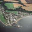
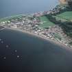
The site of a former church and churchyard of Cromarty, now covered by the sea, is marked by 'the Kirstanes' below the Fishertown. About 1815, the beach below the town was covered with human bones and hewn stones from this graveyard. They were buried in the present church-yard. According to Macrae a former church of Cromarty, possibly this one, was dedicated to St. Moluag (ob. 592), but Simpson does not note it. The present church (NH76NE 10) was probably built in 1593.
G Mackenzie 1958; H Miller 1835; N Macrae 1923; W D Simpson 1935.
There is no trace of either church or churchyard. Mr James Hogg (High Street, Cromarty) indicated the former area of the Kirkstanes, now covered by the sea, at NH 791 675.
Visited by OS (N K B) 28 January 1966.
St Moluag's Church; eroded by the sea; unlocated - not visited.
16th century AD and earlier.
CFA/MORA Coastal Assessment Survey 1998.

