
Pricing Change
New pricing for orders of material from this site will come into place shortly. Charges for supply of digital images, digitisation on demand, prints and licensing will be altered.
Chanonry Point, Ferry Pier


Pier (Period Unassigned)
Site Name Chanonry Point, Ferry Pier
Classification Pier (Period Unassigned)
Alternative Name(s) Chanonry Ness; Chanonry Point, Jetty; Chanonry Pier; Channery; Inner Moray Firth; Beauly Firth
Canmore ID 14372
Site Number NH75NW 52
NGR NH 74876 55638
Datum OSGB36 - NGR
Permalink http://canmore.org.uk/site/14372


- Council Highland
- Parish Rosemarkie
- Former Region Highland
- Former District Ross And Cromarty
- Former County Ross And Cromarty
NH75NW 52 74876 55638
Jetty [NAT]
OS (GIS) AIB, April 2006.
Location formerly cited as NH 7487 5562.
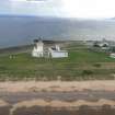
For nearby icehouse (NH 74716 55744) and lighthouse (NH 74944 55704), see NH75NW 55 and NH75NW 70 respectively.
NMRS REFERENCE
Architect: Thos. Telford (1803 - 21).
(Undated) evidence in NMRS.
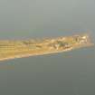
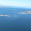
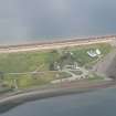
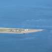
(Location cited as NH 748 557). Chanonry Pier, late 18th to early 19th century. A ramped masonry ferry pier with a central protective wall, formerly used for a ferry to Ardersier. Nearby are two large vaulted ice-houses.
J R Hume 1977.
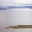
(Location cited as NH 750 557). Chanonry Point: this point formed no part of either Fortrose (NH75NW 65.00) or Rosemarkie (NH75NW 76), although it was included in the parish account of the latter. It carried the terminal of a ferry from Fort George (NH75NE 3), and in 1840 a steamer was making weekly calls. Gibb includes 'Channery' among piers constructed by T Telford in 1819.
Structure.
The ferry pier is a massive, lengthy, elegant structure of large red stone blocks, 250yds (228m) long and over 6yds (5.5m) wide. Seven courses high at the point, 110yds (100.5m) from the shore, where the pier turns slightly eastwards, it slopes to five courses at the tip. Only the lowest, outermost block is slightly undercut by the sea. A parapet wall running nearly the full length of the W side, with a neatly curved butt at each end, shows slight signs of wear at about the half tide mark, the level at which so many works are initially breached by wave action. It is secured by iron straps, and a continuous central linear cramp, in sections of uneven length to accommodate the uneven sizes of the blocks, held in place by flat-headed iron bolts. Two very large iron rings, on ring-headed bolts, survive near the shore end of the pier. The massive kerb blocks of the pier margin are carefully fitted, alternately long and short sides out, to form keys for the stones of the pavement, and are curved on the outer edge. The tip of the parapet wall is of five courses, including two heavy capstones, the top one neatly curved. The parapet stops a little short of the pier end, leaving an angular platform accessible from the sea on two sides. All faces of the pier and parapet wall are battered, no doubt because this was believed to strengthen them, and certainly with fine aesthetic effect.
A Gibb 1935; A Graham and J Gordon 1988.
Jetty; architect Telford - visited.
CFA/MORA Coastal Assessment Survey 1998.
Photographic Survey (July 1961)
Photographs of buildings at Chanonry Point, Ross and Cromarty, by the Scottish National Buildings Record in 1961.

