
Pricing Change
New pricing for orders of material from this site will come into place shortly. Charges for supply of digital images, digitisation on demand, prints and licensing will be altered.
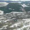
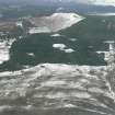
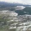
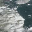
Heights Of Keppoch


Cairnfield (Prehistoric)(Possible)
Site Name Heights Of Keppoch
Classification Cairnfield (Prehistoric)(Possible)
Alternative Name(s) Druim Dubhran
Canmore ID 12950
Site Number NH56SW 5
NGR NH 5006 6110
NGR Description Centred on NH 5006 6110
Datum OSGB36 - NGR
Permalink http://canmore.org.uk/site/12950


- Council Highland
- Parish Fodderty
- Former Region Highland
- Former District Ross And Cromarty
- Former County Ross And Cromarty
NH56SW 5 500 610 to 501 611.
(Centred NH 500 610 & NH 501 611) Cairns (NR) (9 shown)
OS 6"map, (1969)
Small mounds of earth and stone.
Name Book 1876.
On a partially afforested ridge are about 30 stone clearance heaps, including the nine previously published as cairns. They are of a type usually found in association with hut circles.
Visited by OS (N K B) 21 December 1970
No change to previous field report; no cultivation plots are discernible.
Visited by OS (J B) 11 November 1976.
Field Visit (30 August 1943)
This site was included within the RCAHMS Emergency Survey (1942-3), an unpublished rescue project. Site descriptions, organised by county, vary from short notes to lengthy and full descriptions and are available to view online with contemporary sketches and photographs. The original typescripts, manuscripts, notebooks and photographs can also be consulted in the RCAHMS Search Room.
Information from RCAHMS (GFG) 10 December 2014.
Note (1979)
Heights of Keppoch NH 500 610 NH56SW 5
A scatter of small cairns.
RCAHMS 1979
(Name Book, Ross-shire, no. 9, p. 60)

