
Pricing Change
New pricing for orders of material from this site will come into place shortly. Charges for supply of digital images, digitisation on demand, prints and licensing will be altered.
Upcoming Maintenance
Please be advised that this website will undergo scheduled maintenance on the following dates:
Thursday, 30 January: 11:00 AM - 3:00 PM
During these times, some functionality such as image purchasing may be temporarily unavailable. We apologise for any inconvenience this may cause.
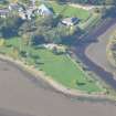
Dingwall Canal, Dingwall Harbour Footbridge


Footbridge (19th Century)
Site Name Dingwall Canal, Dingwall Harbour Footbridge
Classification Footbridge (19th Century)
Alternative Name(s) River Peffery
Canmore ID 218912
Site Number NH55NE 24.02
NGR NH 56047 58543
Datum OSGB36 - NGR
Permalink http://canmore.org.uk/site/218912


- Council Highland
- Parish Dingwall
- Former Region Highland
- Former District Ross And Cromarty
- Former County Ross And Cromarty
NH55NE 24.02 56047 58543
Location formerly cited as NH 5605 5855.
This footbridge over the canal, just to the N of the harbour, is clearly marked as such on the 1st edition of the OS 6-inch map (Ross-shire 1881, sheet lxxxviii) and is visible on the current edition of the OS 1:10000 map (1992).
Information from RCAHMS (MD) 25 July 2002.
This bridge carries a footpath over the Dingwall Canal (the canalised River Peffery) to the NW of the harbour remains NH55NE 24.03. It is depicted, but not noted, on the 1992 edition of the OS 1:10,000 map.
The location assigned to this record defines the centre of the structure. The available map evidence suggests that it extends from NH c. 56039 58537 to NH c. 56057 58549.
Information from RCAHMS (RJCM), 5 April 2006.

