
Pricing Change
New pricing for orders of material from this site will come into place shortly. Charges for supply of digital images, digitisation on demand, prints and licensing will be altered.
Skye, Dun Ban


Dun (Prehistoric)
Site Name Skye, Dun Ban
Classification Dun (Prehistoric)
Canmore ID 11661
Site Number NG71SW 2
NGR NG 7012 1065
Datum OSGB36 - NGR
Permalink http://canmore.org.uk/site/11661


- Council Highland
- Parish Sleat
- Former Region Highland
- Former District Skye And Lochalsh
- Former County Inverness-shire
NG71SW 2 7012 1065.
NG 7012 1065 Dun Ban (NR)
OS 6" map, Inverness-shire, 2nd ed., (1903)
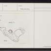
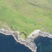
The site of Dun Ban is a flat-topped rock rising some 40 ft above the sea and 25 ft above the neck joining it to the mainland. The summit, an irregular oval, measuring about 60 ft in length along its main axis, ENE-WSW, and some 30 ft in breadth, has been surrounded by a drystone wall on the edge of the rock. It can be traced for the greater part of the circumference except at the NE extremity.
The name Dun Ban (white fort) is accounted for by the rock being partly composed of white quartz.
(RCAHMS 1928).
Dun Ban, a dun, correctly described by RCAHMS. In very poor condition.
Surveyed at 1/2500.
Visited by OS (A S P) 16 June 1961.
Field Visit (8 May 1914)
Dun Ban, Camascross.
On the west side of the Sound of Sleat, about 5/8 mile south-east of the township of Camascross, is a flat-topped rock rising some 40 feet above the sea and 25 feet above the neck joining it to the mainland, the site of Dun Ban. The summit, an irregular oval, measuring about 60 feet in length along its main axis, which runs east-north-east and west-south-west, and some 30 feet in breadth, has been surrounded by a wall of drystone on the edge of the rock. It can be traced for the greater part· of the circumference except at the north-east extremity. The name Dun Ban (white fort) is accounted for by the rock being partly composed of white quartz.
RCAHMS 1928, visited 8 May 1914.
OS map: Skye Iii.
Note (November 2000)
This site was visited during a pre-afforestation survey by Wordsworth Archaeological Services in November 2000 (site 6). The dun is built on a grassy stack and measures c17m x 10m. Distinct wall facing is not evident, though the amount of stone debris suggests there was once a wall here.
Information from Wordsworth Archaeological Services, November 2000.

