
Pricing Change
New pricing for orders of material from this site will come into place shortly. Charges for supply of digital images, digitisation on demand, prints and licensing will be altered.
Canna, Rubha Nic Eamoin


Fort (Period Unassigned)
Site Name Canna, Rubha Nic Eamoin
Classification Fort (Period Unassigned)
Alternative Name(s) Rudha Nic Eamoin; Tarbert
Canmore ID 10767
Site Number NG20SW 3
NGR NG 2379 0485
Datum OSGB36 - NGR
Permalink http://canmore.org.uk/site/10767


- Council Highland
- Parish Small Isles
- Former Region Highland
- Former District Lochaber
- Former County Inverness-shire
NG20SW 3 2379 0485.
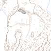
The remains of a fort occupy the promontory of Rudha Nic Eamoin at NG 2379 0485. The defences consisted of a curving turf-covered stony rampart (spread to about 5.5m and about 1.0m high) across the promontory, from the cliff edge to a natural escarpment. About 20.0m to the S are the ill-defined remains of another rampart (spread to about 3.5m and 0.5m high) running E-W across the promontory and stopping short of the cliff. The internal area measures about 20.0m N-S by 27.0m. In the interior and abutting onto the E end of the S rampart are traces of a turf-covered enclosure measuring about 6.0m in diameter. About 20.0m outside the fort in the N are the slight remains of a turf-covered wall of probable later date.
Surveyed at 1:10,000.
Visited by OS (I S S) 23 May 1972.
This fort is situated on a precipitous promontory at the foot of the coastal escarpment due S of Tarbert. It is defended by a single rampart, which encloses an area measuring 32m from E to W by 21m transversely on the highest part of the promontory. The rampart forms a stony bank up to 5m in thickness and 1m in height on the landward (N) side of the promontory, but where it swings around onto the E and S it has been reduced to little more than a stony scarp; with the exception of some possible outer face at the NW corner, no trace of the rampart can be seen along the cliff-edge on the W. The grass-grown interior is featureless. The entrance is probably on the E, opening outwards onto the lowest part of the promontory, and the only approach from the neck on the landward side is overlooked by the rampart. Along the cliff-edge forming the W side of the neck a row of large boulders is visible, and there are also traces of a low bank cutting across the neck from E to W some 15m outside the rampart. The rest of the promontory is featureless, much of it bare rock.
(Canna 1015).
Visited by RCAHMS (SPH), 4 January 1994.
Field Visit (23 May 1972)
The remains of a fort occupy the promontory of Rudha Nic Eamoin at NG 2379 0485. The defences consisted of a curving turf-covered stony rampart (spread to about 5.5m and about 1.0m high) across the promontory, from the cliff edge to a natural escarpment. About 20.0m to the S are the ill-defined remains of another rampart (spread to about 3.5m and 0.5m high) running E-W across the promontory and stopping short of the cliff. The internal area measures about 20.0m N-S by 27.0m. In the interior and abutting onto the E end of the S rampart are traces of a turf-covered enclosure measuring about 6.0m in diameter. About 20.0m outside the fort in the N are the slight remains of a turf-covered wall of probable later date.
Surveyed at 1:10,000.
Visited by OS (I S S) 23 May 1972.
Field Visit (4 January 1994)
This fort is situated on a precipitous promontory at the foot of the coastal escarpment due S of Tarbert. It is defended by a single rampart, which encloses an area measuring 32m from E to W by 21m transversely on the highest part of the promontory. The rampart forms a stony bank up to 5m in thickness and 1m in height on the landward (N) side of the promontory, but where it swings around onto the E and S it has been reduced to little more than a stony scarp; with the exception of some possible outer face at the NW corner, no trace of the rampart can be seen along the cliff-edge on the W. The grass-grown interior is featureless. The entrance is probably on the E, opening outwards onto the lowest part of the promontory, and the only approach from the neck on the landward side is overlooked by the rampart. Along the cliff-edge forming the W side of the neck a row of large boulders is visible, and there are also traces of a low bank cutting across the neck from E to W some 15m outside the rampart. The rest of the promontory is featureless, much of it bare rock.
(Canna 1015).
Visited by RCAHMS (SPH), 4 January 1994.
Measured Survey (6 April 1995)
RCAHMS surveyed the fort at Rubha nic Eamoin, Canna on 6 April 1995 with plane-table and self-reducing alidade at a scale of 1:500. The plan was later used as the basis for an illustration which was published in 2016 (Hunter, fig. 2.17).
Note (13 January 2015 - 28 January 2017)
This fort occupies a precipitous promontory on the southern coast of Canna due S of the isthmus at Tarbert. Its defences comprise a single rampart reduced to a bank some 5m in thickness by 1m in height, which not only cuts across the neck, but seems also to extend along the E and S flanks of the summit area, where it is reduced to a stony scarp. The area it encloses on the top of the promontory measures about 32m from E to W by 21m transversely (0.06ha), but the promontory itself is considerably larger, descending down to two fingers of rock projecting southwards (0.14ha). The entrance is probably on the E, opening onto the lower part of the promontory, to which access from the neck is overlooked by the rampart; this approach exposes the right-hand side of any visitor. There are also traces of another low bank cutting across the neck of the promontory 15m outside the rampart, though this may not be associated with the defences, while the purpose of a row of boulders exposed on the W side of the neck is unknown.
Information from An Atlas of Hillforts of Great Britain and Ireland – 28 January 2017. Atlas of Hillforts SC2689

