
Pricing Change
New pricing for orders of material from this site will come into place shortly. Charges for supply of digital images, digitisation on demand, prints and licensing will be altered.
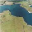
Canna, Coroghon


Clearance Cairn(S) (Period Unassigned), Field System (Period Unassigned), Lazy Beds (Post Medieval)
Site Name Canna, Coroghon
Classification Clearance Cairn(S) (Period Unassigned), Field System (Period Unassigned), Lazy Beds (Post Medieval)
Alternative Name(s) A' Chill; Corrygan
Canmore ID 142446
Site Number NG20NE 110
NGR NG 2653 0607
NGR Description NG 2653 0607 to NG 2806 0591
Datum OSGB36 - NGR
Permalink http://canmore.org.uk/site/142446


- Council Highland
- Parish Small Isles
- Former Region Highland
- Former District Lochaber
- Former County Inverness-shire
NG20NE 110 2653 0607 to 2806 0591
An estate map of Canna dated 1805 shows the farm of ?Corrygan? (Coroghon) occupying the E end of the island. It is separated from the neighbouring farm of ?Keill? (A?Chill) by a march dyke (NG20NE 109), shown on the map as a dotted line, which runs roughly from N to S from above the cliffs to the NE of Carn a? Ghaill to a point halfway across the interior of the island. From here, the march turns E along the upper edge of a rocky crag as far as Cnoc Bhrostan, before again turning S to meet the N shore of Canna Harbour. Its course is unlike those between the other farms or any of the other boundaries that cut across the island. If it behaved like those, it would have continued S down the gully of the Allt Lag a? Ghriumadeal where, indeed, stretches of field-banks can be seen. Thus, the pronounced dog-leg in the march dyke may result from the redefinition of earlier boundaries on the island. Another bank, which cuts across the island to the W of Compass Hill, is not only of considerable thickness, but has also been refurbished with a stone dyke, probably indicating a long period of use and maintenance. By 1805, the island appears to be divided between separate farms, but these boundaries probably originated as the lands held by the townships.
The estate map also shows several buildings, the Changehouse and barn (NG20NE 25), a barn and building at Coroghon (NG20NE 26) and the predecessor to Canna House (NG20NE 44) on the NE shore of Canna Harbour. The house was occupied by Hector MacNeill, a leaseholder on Canna, and the adjacent fields, annotated on the map as enclosures but shown under cultivation, were probably tied in with his lease. The extent of these enclosures corresponds with the area of improved ground shown on the 1st edition of the OS 6-inch map (Argyllshire, 1881, sheet lix), and continues in use today as the enclosed fields belonging to the modern farm.
Beyond these enclosures, the map identifies several areas of arable ground, the largest of which occupies ground immediately adjacent to or overlooking the enclosures, while two smaller isolated areas lie on a narrow terrace below Cnoc Bhrostan and at the head of the burn gully to the W of Blar na Carraigh respectively. Small plots of lazy-beds survive in all these areas, but none extends across the entirety of the areas shown on the map; that on the headland at Rubha Carr-innis appears to be the most complete. Further small plots of lazy-beds were also identified outwith the cultivated ground shown on the map, most notably to the W of Compass Hill, where there are also several large enclosures, and an extensive cluster of probable shieling-huts, indicating several phases of land-use. The remainder of the farm of ?Corrygan? is given over to pasture, including the small tidal island of Alman, to the SSE of Coroghon Castle, but this too has been cultivated at some point and bears traces of two small plots of lazy-beds.
Visited by RCAHMS (ARG), 24 November 1997.

