
Following the launch of trove.scot in February 2025 we are now planning the retiral of some of our webservices. Canmore will be switched off on 24th June 2025. Information about the closure can be found on the HES website: Retiral of HES web services | Historic Environment Scotland
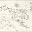
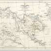
St Kilda, Hirta, Village Bay


Village (Medieval)
Site Name St Kilda, Hirta, Village Bay
Classification Village (Medieval)
Canmore ID 9661
Site Number NF19NW 15
NGR NF 101 995
NGR Description Centred at NF 101 995
Datum OSGB36 - NGR
Permalink http://canmore.org.uk/site/9661


- Council Western Isles
- Parish Harris
- Former Region Western Isles Islands Area
- Former District Western Isles
- Former County Inverness-shire
NF19NW 15 9101 995.
See also NF19NW 21 NF 101 993 St Kilda village
(Area: NF 101995) According to Macaulay in 1764 (K Macaulay 1764), the medieval village of St Kilda comprised houses built in two rows...facing one another with a tolerable causeway in the middle...called the Street'. This was 1/4 mile from the sea (ie. twice the distance of the 1830-60 village). He adds that 'Tobar Childa (NF19NW 13) was 'near the heart of the village'.
Both Williamson (K Williamson and J M Boyd 1963) and Macgregor (D R Macgregor 1960) are of the opinion that the site of the (? 1400-1830) village extended from Tobar Childa in a SE direction to the factor's house, following the line of a natural embankment which may well be Macaulay's 'causeway'. Macgregor notes 'a significant number of vestiges of circular middens and ash-pits' along this line, and remarks on the situation being favoured by both sun and shelter.
Both agree that Tobar Childa was the probable nucleus of the village and Williamson points out that the group of 'Cleitean' here represents all that is left of the old village, and that many of these structures have features which indicate that they were built in the first place as dwellings.
K Macaulay 1764; K Williamson and J M Boyd 1960 and 1963; D R Macgregor 1960.
That the pre-1830 settlements probably existed in the area described by the foregoing authorities to the north of the present village, is not disputed; but three major points arise out of this:
(1) Only three or four possible medieval or 'beehive' type dwellings were noted (in addition to Calum Mor House - NF19NW 2), and these have been re-used/re-built as cleits.
(2) No early black-house structure of Martin & Macaulay's description seems to survive - and this village may just have been superseded, in situ, by the 1834 'improved black-houses'.
(3) The possibility of hut circles existing near Tobar Childa, together with a field-stystem, indicates a pre- historic settlement (see NF09NE 9).
The probable head-dyke (mainly a baulk) containing the 17/18th centuries field plots, was also located running erratically from the present wall near the site of Tobar a' Chleirich at a distance of c.15-20m from the wall, to a point above Tobar Childa at a distance of c.100m where the baulk (2-3m high) changes to a turf-covered boulder wall no more than 0.2m high. It is last seen turning southwards towards the modern wall some 200m W of Tobar Childa. No traces of cultivation lie outside this bank (excepting the enclosures on An Lag); but the plots exist for a short way inside the 1830 wall, gradually being superseded by the field strip system of that and later date.
The natural embankment N of the E end of the village, seems to erratic and not convincing enough to be Macaulay's "causeway" of the old village.
Contrary to Williamson's suggestion that the cleits near Tobar Childa were originally dwellings, only about three of these, and obviously reconstructed on earlier foundations, can be said to possibly agree with this theory - the narrowness of the internal area, and the special 'open' construction of the walls, is not conductive to habitation. Visited by OS (J L D) 7 August 1967.
NF 101 993 Fieldwork has identified the site of the clachan which pre-dates and was not totally destroyed by the familiar 1830s 'improvement' layout of crofts and blackhouses set along a 'street'. Thirteen possible or probable structures are identifiable, centring around the present House 9; sometimes they partly underlie 1830s structures, elsewhere they take the form of sub-rectangular or slightly boat-shaped hollows or platforms. At the S end of the clachan is a 'dished area', evidently a public space which compares well in detail with the drawing made by Acland in 1812.
Sponsor: University of Wales Lampeter - Dept of Archaeology
A Fleming 2002
A coastal erosion study carried out between 2003 and 2005 revealed that the island had suffered from a metre of erosion during that 3 year time period.
S Dennis 2005
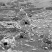
A survey was carried out by the National Trust for Scotland on over 300 cleitean (singular cleit) on St Kilda. They are double-walled, drystone-built oval or rectangular structures, used primarily for storage of food and fuel resources. Many have survived well after being abandoned in 1930 when the islands were evacuated. The survey recorded their condition, construction and location.
M Taylor 2001
Desk Based Assessment (28 April 1966)
(Area: NF 101995) According to Macaulay in 1764 (K Macaulay 1764), the medieval village of St Kilda comprised houses built in two rows...facing one another with a tolerable causeway in the middle...called the Street'. This was 1/4 mile from the sea (ie. twice the distance of the 1830-60 village). He adds that 'Tobar Childa (NF19NW 13) was 'near the heart of the village'.
Both Williamson (K Williamson and J M Boyd 1963) and Macgregor (D R Macgregor 1960) are of the opinion that the site of the (? 1400-1830) village extended from Tobar Childa in a SE direction to the factor's house, following the line of a natural embankment which may well be Macaulay's 'causeway'. Macgregor notes 'a significant number of vestiges of circular middens and ash-pits' along this line, and remarks on the situation being favoured by both sun and shelter.
Both agree that Tobar Childa was the probable nucleus of the village and Williamson points out that the group of 'Cleitean' here represents all that is left of the old village, and that many of these structures have features which indicate that they were built in the first place as dwellings.
K Macaulay 1764; K Williamson and J M Boyd 1960 and 1963; D R Macgregor 1960.
Field Visit (7 August 1967)
That the pre-1830 settlements probably existed in the area described by the foregoing authorities to the north of the present village, is not disputed; but three major points arise out of this:
(1) Only three or four possible medieval or 'beehive' type dwellings were noted (in addition to Calum Mor House - NF19NW 2), and these have been re-used/re-built as cleits.
(2) No early black-house structure of Martin & Macaulay's description seems to survive - and this village may just have been superseded, in situ, by the 1834 'improved black-houses'.
(3) The possibility of hut circles existing near Tobar Childa, together with a field-stystem, indicates a pre- historic settlement (see NF09NE 9).
The probable head-dyke (mainly a baulk) containing the 17/18th centuries field plots, was also located running erratically from the present wall near the site of Tobar a' Chleirich at a distance of c.15-20m from the wall, to a point above Tobar Childa at a distance of c.100m where the baulk (2-3m high) changes to a turf-covered boulder wall no more than 0.2m high. It is last seen turning southwards towards the modern wall some 200m W of Tobar Childa. No traces of cultivation lie outside this bank (excepting the enclosures on An Lag); but the plots exist for a short way inside the 1830 wall, gradually being superseded by the field strip system of that and later date.
The natural embankment N of the E end of the village, seems to erratic and not convincing enough to be Macaulay's "causeway" of the old village.
Contrary to Williamson's suggestion that the cleits near Tobar Childa were originally dwellings, only about three of these, and obviously reconstructed on earlier foundations, can be said to possibly agree with this theory - the narrowness of the internal area, and the special 'open' construction of the walls, is not conductive to habitation. Visited by OS (J L D) 7 August 1967.
Conservation (2001)
NF 101 991 (centre) As part of the Management Agreement with Historic Scotland, the monuments within Village Bay were recorded and monitored, and certain cleits, dykes and enclosures were repaired in 2001 under supervision by members of the two volunteer work parties. Detailed work included the completion of the identification of around 300 cleits for active management, and the production of a report on cleit preservation, as well as rapid assessments of coastal erosion and the deposition of builders' debris within some of the roofless structures along the village street.
Report to be deposited in the NMRS.
Photographic Survey (2002)
NF 101 991 (centre) As part of the Management Agreement with Historic Scotland, the monuments within Village Bay were recorded and monitored, and certain cleits, dykes, drains and enclosures were repaired under supervision by members of the volunteer work parties which went out to St Kilda in 2002.
A photographic survey of the coastline in Village Bay was carried out and compared to images taken in 1999. The survey indicated erosion along the NE side of the bay. Two sherds of hand-made pottery were recovered and a layer of burning noted in an exposed section.
The annual monitoring of cleits across the island was carried out and the photographic survey of them continued.
Report to be deposited in the NMRS.
Sponsors: HS, NTS.
S Bain 2002
Project (3 September 2007 - 7 September 2007)
NF 101 995 (centred on) Ground Penetrating Radar (GPR) survey was undertaken between 3–7 September 2007 with the aim of identifying any surviving Bronze Age cists. Only a small area could be investigated in the time available and while many anomalies of potential archaeological interest have been detected no responses clearly indicative of cists were noted. A small area of resistance survey was carried out over the suspected location of St Columbus Chapel and the results show a well defined rectilinear response likely to be associated with the Chapel. Unfortunately it would appear that much of the chapel was lost during road construction.
Archive deposited with the Geophysics Unit, Orkney College.
Funder: IWC Media.
Earth Resistance Survey (3 September 2007 - 7 September 2007)
NF 101 995 (centred on) A small area of resistance survey was carried out over the suspected location of St Columbus Chapel and the results show a well defined rectilinear response likely to be associated with the Chapel. Unfortunately it would appear that much of the chapel was lost during road construction.
Archive deposited with the Geophysics Unit, Orkney College.
Funder: IWC Media.
Ground Penetrating Radar (3 September 2007 - 7 September 2007)
NF 101 995 (centred on) Ground Penetrating Radar (GPR) survey was undertaken between 3–7 September 2007 with the aim of identifying any surviving Bronze Age cists. Only a small area could be investigated in the time available and while many anomalies of potential archaeological interest have been detected no responses clearly indicative of cists were noted.
Archive deposited with the Geophysics Unit, Orkney College.
Funder: IWC Media.

