
Pricing Change
New pricing for orders of material from this site will come into place shortly. Charges for supply of digital images, digitisation on demand, prints and licensing will be altered.
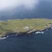
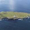
The Kiln, Muckle Skerry


Burnt Mound (Prehistoric)(Possible)
Site Name The Kiln, Muckle Skerry
Classification Burnt Mound (Prehistoric)(Possible)
Alternative Name(s) Pentland Skerries; Pentland Firth
Canmore ID 9507
Site Number ND47NE 3
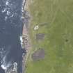
NGR ND 4638 7844
Datum OSGB36 - NGR
Permalink http://canmore.org.uk/site/9507


- Council Orkney Islands
- Parish South Ronaldsay
- Former Region Orkney Islands Area
- Former District Orkney
- Former County Orkney
ND47NE 3 4638 7844.
About one-third of a small Early Iron Age vessel was found by the keeper of the Pentland Skerries lighthouse in a mound about 100 yards NW of the lighthouse on Muckle Skerry. It is now in Stromness Museum.
I H Longworth 1965
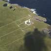
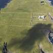
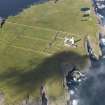
There is no record of this find at Stromness, but a turf-covered stony mound at ND 4638 7844 measuring 13.0m E-W by 11.0m N-S and 1.0m high is probably the mound referred to by Longworth. It has been quarried into from the west side exposing the top of a slab 1.1m. long set on edge. Traces of a wall about 0.8m wide can also be seen extending from the S side. The origin of the mound is uncertain, yet it cannot be positively identified as a cairn.
Surveyed at 1/10,000.
Visited by OS (ISS) 8 May 1973
This is a possible burnt mound. The centre was excavated revealing slab structure. This was probably the find spot of a pot. Further slab structures are around mound. OR 498
Information from R Lamb.
Field Visit (8 May 1973)
There is no record of this find at Stromness, but a turf-covered stony mound at ND 4638 7844 measuring 13.0m E-W by 11.0m N-S and 1.0m high is probably the mound referred to by Longworth. It has been quarried into from the west side exposing the top of a slab 1.1m. long set on edge. Traces of a wall about 0.8m wide can also be seen extending from the S side. The origin of the mound is uncertain, yet it cannot be positively identified as a cairn.
Surveyed at 1/10,000.
Visited by OS (ISS) 8 May 1973

