Pricing Change
New pricing for orders of material from this site will come into place shortly. Charges for supply of digital images, digitisation on demand, prints and licensing will be altered.
Upcoming Maintenance
Please be advised that this website will undergo scheduled maintenance on the following dates:
Thursday, 9 January: 11:00 AM - 3:00 PM
Thursday, 23 January: 11:00 AM - 3:00 PM
Thursday, 30 January: 11:00 AM - 3:00 PM
During these times, some functionality such as image purchasing may be temporarily unavailable. We apologise for any inconvenience this may cause.
Hempriggs
Broch (Iron Age)(Possible)
Site Name Hempriggs
Classification Broch (Iron Age)(Possible)
Alternative Name(s) Wic 183; Hempriggs House Policies; Hempriggs House Lodge Broch
Canmore ID 8957
Site Number ND34NE 4
NGR ND 3511 4717
Datum OSGB36 - NGR
Permalink http://canmore.org.uk/site/8957
- Council Highland
- Parish Wick
- Former Region Highland
- Former District Caithness
- Former County Caithness
ND34NE 4 3511 4717.
(ND 3511 4717) Broch (NR) (rems of)
OS 6" map, (1970)
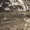
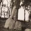
Broch, Hempriggs: A grassy mound some 10ft high which has been partially removed on the E side covers the remains of this broch, no details of which are obtainable other than that its diameter has been about 56ft over all.
RCAHMS 1911.
A much mutilated mound of earth and stone about 2.1m high and 18m in diameter. The mound has been dug into on the S side revealing much loose stone, but no traces of any walling. On the SE perimeter another excavation has revealed what is possibly the footings of the outer wall of a broch, but further excavation is required to substantiate this. Although the area is much mutilated and disturbed, this is probably the remains of a broch, surrounded by a berm some 12m wide.
Revised at 1:2500.
Visited by OS (W D J) 21 April 1963.
The broch is as described by the previous field investigator. It follows the typical Caithness broch pattern of 'mound on mound'. The lower mound, presumably covering secondary structures, is from the S about 1.5m high and 42.0m across; the mound representing the broch is an additional 1.5m high.
Visited by OS (J B) 2 September 1982.
Field Visit (1911)
Broch, Hempriggs: A grassy mound some 10ft high which has been partially removed on the E side covers the remains of this broch, no details of which are obtainable other than that its diameter has been about 56ft over all.
RCAHMS 1911.
Antiquarian Observation (October 1931)
Note by L Duff Dunbar regarding a long cist discovered dug into the SW flanks of the broch mound in October 1931. Only part of the cist survived, the rest had been destroyed previously.
Field Visit (21 April 1963)
A much mutilated mound of earth and stone about 2.1m high and 18m in diameter. The mound has been dug into on the S side revealing much loose stone, but no traces of any walling. On the SE perimeter another excavation has revealed what is possibly the footings of the outer wall of a broch, but further excavation is required to substantiate this. Although the area is much mutilated and disturbed, this is probably the remains of a broch, surrounded by a berm some 12m wide.
Revised at 1:2500.
Visited by OS (W D J) 21 April 1963.
Project (1980 - 1982)
Field Visit (2 September 1982)
The broch is as described by the previous field investigator. It follows the typical Caithness broch pattern of 'mound on mound'. The lower mound, presumably covering secondary structures, is from the S about 1.5m high and 42.0m across; the mound representing the broch is an additional 1.5m high.
Visited by OS (J B) 2 September 1982.
Publication Account (2007)
ND34 6 HEMPRIGGS ND/3511 4717
Possible broch in Wick, Caithness, consisting of a grassy mound 3m (10ft) high with an overall diameter of 42m (56ft) which has been partly removed on the east side. It is a 'mound on a mound', the upper one being 1.5m high and 16.8m (56ft) in diameter and resting on top of a lower mound or platform about 1.5m high and 42m across. There is a flat berm between the two about 12m wide [1].
Sources: 1. NMRS site no. ND 34 NE 4: 2. RCAHMS 1911b, 146, no. 504.
E W MacKie 2007


