
Pricing Change
New pricing for orders of material from this site will come into place shortly. Charges for supply of digital images, digitisation on demand, prints and licensing will be altered.
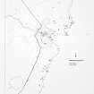
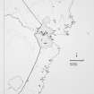
Toftcarl


Farmstead (Period Unassigned)
Site Name Toftcarl
Classification Farmstead (Period Unassigned)
Alternative Name(s) Wic 186
Canmore ID 8954
Site Number ND34NE 12
NGR ND 3573 4611
Datum OSGB36 - NGR
Permalink http://canmore.org.uk/site/8954


- Council Highland
- Parish Wick
- Former Region Highland
- Former District Caithness
- Former County Caithness
ND34NE 12 3573 4611.
The remains of a modern croft, 24m by 5m.
C E Batey 1981
Stone footings of a croft-house, 0.4m in average height, with associated field banks.
Visited by OS 1 September 1982.
A farmstead comprising one unroofed long building attached to an incomplete enclosure is depicted on the 1st edition of the OS 6-inch map (Caithness 1876, sheet xxx) and on the current edition of the OS 1:10,560 map (1970).
Information from RCAHMS (SAH) 25 January 1996
Project (1980 - 1982)
Field Visit (1981)
The remains of a modern croft, 24m by 5m.
C E Batey 1981

