
Toftcarl


Farmstead (Period Unassigned)
Site Name Toftcarl
Classification Farmstead (Period Unassigned)
Alternative Name(s) Wic 186
Canmore ID 8954
Site Number ND34NE 12
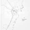
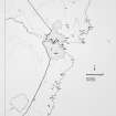
NGR ND 3573 4611
Datum OSGB36 - NGR
Permalink http://canmore.org.uk/site/8954


- Council Highland
- Parish Wick
- Former Region Highland
- Former District Caithness
- Former County Caithness
ND34NE 12 3573 4611.
The remains of a modern croft, 24m by 5m.
C E Batey 1981
Stone footings of a croft-house, 0.4m in average height, with associated field banks.
Visited by OS 1 September 1982.
A farmstead comprising one unroofed long building attached to an incomplete enclosure is depicted on the 1st edition of the OS 6-inch map (Caithness 1876, sheet xxx) and on the current edition of the OS 1:10,560 map (1970).
Information from RCAHMS (SAH) 25 January 1996
Project (1980 - 1982)
Field Visit (1981)
The remains of a modern croft, 24m by 5m.
C E Batey 1981

