
Brough


Castle (Medieval), Settlement (Period Unassigned)
Site Name Brough
Classification Castle (Medieval), Settlement (Period Unassigned)
Alternative Name(s) Castle Of Braigh, Dun 007
Canmore ID 8914
Site Number ND27SW 8
NGR ND 2283 7404
Datum OSGB36 - NGR
Permalink http://canmore.org.uk/site/8914


- Council Highland
- Parish Dunnet
- Former Region Highland
- Former District Caithness
- Former County Caithness
ND27SW 8 2283 7404.
(ND 2283 7404) Castle (NR) (remains of)
OS 1:10,000 map, (1976)
On the landward end of the promontory are the foundations of a castle. A trench some 40ft wide and 10 to 12ft deep has been dug across the neck and on either side of the rock. In rear of this has been a range of buildings separated by a narrow courtyard or passage. The keep is not recognisable. There appears to be no history of this castle.
RCAHMS 1911.
As described by the RCAHMS.
Resurveyed at 1:2500.
Visited by OS (R D) 26 February 1965.
The trench is about 13m long and 4m deep. Many grass-covered foundations of structures of unknown period can be seen on the landward side of the promontory on either side of a raised central track. There is slight erosion of the promontory only on the E side.
C E Batey 1980.
Lamb (1980) records the heavily robbed Castle of Brough as one of a group of promontory-sited castles which includes Borve (NC76SW 2) and Old Man of Wick (ND34NE 2). In each of these sites a feature is the keep, a large, plain tower, standing beside the approach, acting as a focus of defence and protecting the buildings behind it, without actually being a gatehouse as in the 15th - 16th century castles. He suggests that the idea may be Scandinavian and compares these sites with the 12th century Sverresborg in Trondheim and Lilleborg in Bornholm, a royal castle which was abandoned in 1259.
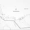
The site of the Castle of Brough is a long, narrow promontory across the neck of which is a broad natural depression which has been enhanced to form a considerable flat-bottomed ditch. At the head of the slope onto the promontory is a large mound of debris in a position corresponding to the keep at Old Man of Wick and Borve. Seaward from this there are two ranges of buildings, identical in size and arrangement to those at Old Man of Wick, extending along the sides of the promontory and leaving a central pathway. At the end, where the surface slopes down to the rocks above the sea, the slope has been steeply scarped, a bank being made at the summit of the scarp and a ditch excavated at its foot, very much as at Borve.
The Castle of Brough is entirely undocumented.
R G Lamb 1980.
The remains are as described by Lamb except that the keep he notes cannot be identified.
Visited by OS (N K B) 21 May 1981.
Mercer classifies 'Brough Castle' as a promontory fort measuring 36m N-S by 13m and 3m high. A bank and ditch cross the neck of the promontory and a series of scoops lie inside.
R J Mercer 1981.
Field Visit (1911)
On the landward end of the promontory are the foundations of a castle. A trench some 40ft wide and 10 to 12ft deep has been dug across the neck and on either side of the rock. In rear of this has been a range of buildings separated by a narrow courtyard or passage. The keep is not recognisable. There appears to be no history of this castle.
RCAHMS 1911.
Field Visit (26 February 1965)
As described by the RCAHMS.
Resurveyed at 1:2500.
Visited by OS (R D) 26 February 1965.
Project (1980 - 1982)
Project (1980 - 1982)
Field Visit (1980)
The trench is about 13m long and 4m deep. Many grass-covered foundations of structures of unknown period can be seen on the landward side of the promontory on either side of a raised central track. There is slight erosion of the promontory only on the E side.
C E Batey 1980.
Field Visit (1980)
Lamb (1980) records the heavily robbed Castle of Brough as one of a group of promontory-sited castles which includes Borve (NC76SW 2) and Old Man of Wick (ND34NE 2). In each of these sites a feature is the keep, a large, plain tower, standing beside the approach, acting as a focus of defence and protecting the buildings behind it, without actually being a gatehouse as in the 15th - 16th century castles. He suggests that the idea may be Scandinavian and compares these sites with the 12th century Sverresborg in Trondheim and Lilleborg in Bornholm, a royal castle which was abandoned in 1259.
The site of the Castle of Brough is a long, narrow promontory across the neck of which is a broad natural depression which has been enhanced to form a considerable flat-bottomed ditch. At the head of the slope onto the promontory is a large mound of debris in a position corresponding to the keep at Old Man of Wick and Borve. Seaward from this there are two ranges of buildings, identical in size and arrangement to those at Old Man of Wick, extending along the sides of the promontory and leaving a central pathway. At the end, where the surface slopes down to the rocks above the sea, the slope has been steeply scarped, a bank being made at the summit of the scarp and a ditch excavated at its foot, very much as at Borve.
The Castle of Brough is entirely undocumented.
R G Lamb 1980.
Field Visit (21 May 1981)
The remains are as described by Lamb except that the keep he notes cannot be identified.
Visited by OS (N K B) 21 May 1981.
Field Visit (1981)
Mercer classifies 'Brough Castle' as a promontory fort measuring 36m N-S by 13m and 3m high. A bank and ditch cross the neck of the promontory and a series of scoops lie inside.
R J Mercer 1981.
Note (18 February 2015 - 18 May 2016)
All the visible elements of this fortification occupying a precipitous promontory on the coast NE of Brough probably belong to an undocumented castle, and if there was an earlier fort here nothing of it remains visible. The defences comprise a ditch some 12m broad and 4m deep cut across the neck on the on the SSW, behind which there was probably a keep guarding an entrance, though nothing of this is visible. Ranges of buildings extend down the margins of the promontory to either side of a central roadway, and there is a bank with an external ditch separating them from the narrow finger of land that projects a further 40m out into the sea. The interior of the castle measures no more than 30m from NNE to SSW by 15m transversely (0.04ha).
Information from An Atlas of Hillforts of Great Britain and Ireland – 18 May 2016. Atlas of Hillforts SC2824

