
Pricing Change
New pricing for orders of material from this site will come into place shortly. Charges for supply of digital images, digitisation on demand, prints and licensing will be altered.
Latheronwheel


Clearance Cairn(S) (Period Unassigned), Enclosure (Period Unassigned), Settlement (Period Unassigned)(Possible)
Site Name Latheronwheel
Classification Clearance Cairn(S) (Period Unassigned), Enclosure (Period Unassigned), Settlement (Period Unassigned)(Possible)
Alternative Name(s) Lat 262-9 & 271-3
Canmore ID 8153
Site Number ND13SE 35
NGR ND 187 320
NGR Description Centred ND 187 320
Datum OSGB36 - NGR
Permalink http://canmore.org.uk/site/8153


- Council Highland
- Parish Latheron
- Former Region Highland
- Former District Caithness
- Former County Caithness
ND13SE 35 centred 187 320
See also ND13SE 36.
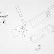
Centred ND 187 320. A complex of features, only one of which, a possible long cairn (ND13SE 36) is classified as prehistoric. Otherwise, the site, described as a settlement, consists of a possible hut circle, two cairnfields, two cairns, a stone setting, an enclosure and miscellaneous mounds and structures.
C Batey 1982.
A general area of early-modern land-use, now given over to rought pasture, in which is situated a walled enclosure and occasional small piles of cleared stone. No other features were noted.
Visited by OS (J M) 15 October 1982.
Project (1980 - 1982)
Field Visit (15 October 1982)
A general area of early-modern land-use, now given over to rought pasture, in which is situated a walled enclosure and occasional small piles of cleared stone. No other features were noted.
Visited by OS (J M) 15 October 1982.

