
Duchary Rock


Fort (Prehistoric)
Site Name Duchary Rock
Classification Fort (Prehistoric)
Canmore ID 6535
Site Number NC80SE 3
NGR NC 850 048
Datum OSGB36 - NGR
Permalink http://canmore.org.uk/site/6535


- Council Highland
- Parish Clyne
- Former Region Highland
- Former District Sutherland
- Former County Sutherland
NC80SE 3 850 048.
(NC 850 048) Fort (NR), (NC 8511 0478) Rock Shelter (NR)
OS 6"map, (1964)
The fort on Duchary Rock is defended at its N and SE ends by a stone wall and elsewhere by natural rock. There is an outer wall 7 feet thick on the NW side protecting an entrance; a second entrance occurs in the SE wall.
A natural rock shelter occurs some 30 feet below the wall in the SE.
RCAHMS 1911, visited 1909.
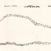
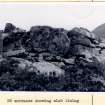
The fort, measuring about 300.0m NW-SE by about 110.0m maximum transversely, is defended by steep natural cliffs along the NE and SW sides, the latter reinforced towards the NW end by a denuded wall, most of which has tumbled over the cliff edges.
The relatively easy approaches from the N and SE are defended by massive bare tone walls largely obscured by tumble, but measuring 4.0m average width and surviving up to 1.5m in height.
There are two opposing entrances at the NW and SE extremities. The former is 1.8m wide, faced on the W side with two upright slabs. The SE entrance is 1.3m wide with indications of a mural chamber on the W side choked with debris.
No evidence of wall faces can be seen in the "outer wall" in the NW mentioned by RCAHMS and it is probable that this is tumble from the fort which has been piled up later.
The interior of the fort is overgrown with peat and no domestic structures can be seen.
The "rock shelter" is a natural cave with no visible evidence of human occupation.
The covered area measures approximately 5.0m by 4.0m.
Revised at 1:10,560.
Visited by OS (E G C) 7 April 1962 and (N K B) 26 August 1975.
In PPS (PPS 1989), Bowden, Mackay and Blood comment on the unusual construction of the dry stone rampart of Ingleborough hillfort, North Yorks. "The rampart is divided transversely, sometimes at inetrvals of only about 2m, by 'throughs' of stones set on edge. The boxes or compartments thus formed are filled with rubble ...... (possibly a feature of lower levels only ?)... ".
In the light of similar features noted at Duchary Rock, and also Cnoc an Duin (NH67NE 1), a new visit was made to Duchary Rock to inspect again the 'entrances' or alternatively 'through joints' noted by eg Hogg, and JCB in Exploring Scots heritage, The Highlands.
The visit was hurried, and no conclusive decisions were reached, but some points emerged.
The possible Southern Entrance, 1.3m wide or so, in S rampart. This one is not slab-lined, but had dry-stone walls (contra Hogg); it also appears to be filled only by tumble, not deliberate blocking, which would support the idea that this feature at least is a genuine entrance. The Inventory for Caithness (RCAHMS 1911), mentions signs of a chamber W of the entrance; this we did not pick up; but there are two upright slabs near the middle (possibly why Hogg suggested slab linings ?)which just could be door-checks, though not exactly opposite one another.
Most curiously, on the east side and just next one (?) check (on its inner side) is something very like a door bar-hole, which runs a long way into the wall, with lined sides. It could perhaps be due to just one square stone falling out, but it is very suggestive; and door-checks and a barhole would fit well with a chamber, if there was indeed one.
North Rampart
Midhole Entrance - E1 on Hogg plan. This, some 2m wide, is probably the original and ? only entrance. It has extra massive stones in the drystone wall each side of it, and is lined with very large thin slabs, against a drystone wall, each side. it is blocked by tumble.
West of this is a feature, marked as E2 on Hoggs plan, of the same width, also with drystone walls running through the rampart each side, also lined with slabs, but filled with deliberate blocking with a well built face to the front of the rampart. This could be either a blocked entrance or a feature like those at Ingleborough; and since there seems no good reason for a second entrance, it may be these are transverse building joints again forming boxes. The use of the 'lining' slabs is curious, but perhaps linked to the Ingleborough practice of using stones set on edge.
The two further instances of single built faces crossing the rampart, noted by Hogg east of the main entrance, were not observed on this visit due to lack of time, it is just such a feature which can be seen clearly in one rampart at Cnoc an Duin.
Visited by Dr J Close-Brooks, 19 May 1990.
Field Visit (30 September 1909)
29. Fort, Duchary Rock. From Kilmain, a crofter township 2 m. W. of Brora, an old peat road leads NW. into the deer forest for nearly 2 m. To the K of this road near its termination rises abruptly a massive rock, precipitous on the E. and W., with a steep slope at the S. end, and a comparatively easy approach from the NW. It bears the name of the Duchary Rock. The level summit, where not defended by nature, has been strongly fortified by a wall. This wall at the N. or NW. end is 12' in thickness, in places 3' high, and well built of flat stones. It is pierced towards the NW. by an entrance passage 6' wide between the faces of the. opposing walls. The wall forming the W. side of the entrance passage is faced with two large fiat slabs apparently in situ. Some 14' outside the wall at this entrance are the foundations of an outer wall some 7' thick seeming to run from a point on the main wall about 10' E. of the opening and to meet it again at the edge of the steep slope 80' or 100' to westward, thus covering the entrance. Between the steep cliffs at the S. end is another wall some 70' in length and 10' thick through which is an entrance 4' wide. On the W. side of it is an indication of a chamber in the wall. The total length of the interior is some 260 yards, and the average width about 60 yards. The immense mass of debris indicates that the height of the walls was considerable.
Some 30' below the outer wall at the SE. is a natural rock shelter, the covered area measuring about 12' x 17'.
In the rocks facing eastwards some 100 yards NE. of the NW. entrance under a large rock is the entrance to an underground passage apparently natural. At its commencement it is about 2' wide and 3' high. It passes inwards in a southerly direction for about 13', then, turning sharply to the right, runs onward for 18' or 20' further with a width of some 15".
OS 6-inch map: Sutherland Sheet xcvii. (unnoted).
RCAHMS 1911, visited (AOC) 30th September 1909.
Publication Account (1995)
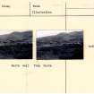
A finely sited fort with an impressive, though tumbled, stone rampart, set high up in open moorland with views to the north and out to sea. The fort occupies a flat-topped ridge some 300m long, with steep precipices on either side. The easier approaches at the north and south ends are each defended by a single stone wall, originally nearly 4m thick but now tumbled. Large blocks and slabs as well as smaller ones were used in the construction of both ramparts. These have unfortunately been considerably disturbed by shepherds making sheep shelters among the tumbled stone. The shorter southeast rampart makes some use of natural rock outcrops in its layout. There is a narrow entrance near the centre,unusual in that it is only 1.3m wide. Perhaps it was a postern gate which could admit people but not carts or sledges.
The longer northern rampart cuts off the ridge from the hills behind. Parts of the other face of this rampart are exposed among the general rumble. About the centre of the rampart is an entrance nearly 5m wide, now partly blocked with fallen stones. Some very large stone slabs line the entrance passage, and the wall-face east of the entrance is constructed of particularly massive blocks. There are some straight building-joints crossing the line of the wall; it has been suggested that these represent further blocked entrances, but it seems more likely that they are simply a local building trait, also to be seen in the apparently unfinished fort at Cnoc an Duin, Ross and Cromarty (NH 696768).
At its east end the northern rampart runs into a well defined precipice. To the west, it continues as a slighter feature sorne way alorig the west side of the fort where the precipice is less pronounced.
Information from ‘Exploring Scotland’s Heritage: The Highlands’, (1995).
Note (4 February 2015 - 18 October 2016)
Duchary Rock, a rocky spur high up on the SW flank of Strath Brora, provides a spectacular setting for one of the larger forts in northern Scotland, with a cliff along the E margin and low crags dropping into steep rocky slopes elsewhere on the SW and to a lesser extent the SE end. The principal defence is a single wall barring access from the NW, where it measures 3.6m in thickness and still stands almost 1m in height, though the spread of tumbled rubble is up to 12m broad; an outer wall noted in by Alexander Curle in 1909 is probably part of this tumble (RCAHMS 1911, 11-12, no.29). A second wall cuts across the SE end of the spur to create a pear-shaped enclosure measuring 290m in length and contracting from a maximum of 110m in breadth on the NW to no more than 50m on the SE (2.3ha). The main entrance is on the NW and measures 1.8m in width and is lined with upright slabs. A second entrance on the SE is narrower, measuring about 1.2m wide, and lined with laid masonry; two upright slabs were noted in 1990 by Joanna Close-Brooks roughly halfway along the passage, and she identified a possible bar-hole slot in the NE face adjacent to one of them. Both these entrances are currently blocked with tumbled stones, but in the NW end A H A Hogg also noted up to four through joints in the thickness of the wall, two lying on the W of the entrance and another two on the E (1975, 194-5); those on the W also incorporate upright slabs, and give the impression that they are the sides of an entrance passage, which has been blocked with neatly laid masonry, and Hogg speculated that the others may be further entrances, which would amount to no fewer than four in this end. The peat-covered interior is featureless.
Information from An Atlas of Hillforts of Great Britain and Ireland – 18 October 2016. Atlas of Hillforts SC2786

