
Pricing Change
New pricing for orders of material from this site will come into place shortly. Charges for supply of digital images, digitisation on demand, prints and licensing will be altered.
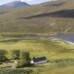
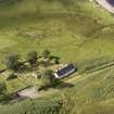
Inchnadamph


Moated Site (Medieval)
Site Name Inchnadamph
Classification Moated Site (Medieval)
Canmore ID 4664
Site Number NC22SW 6
NGR NC 2488 2197
NGR Description 248 219 to 249 220 (for survey)
Datum OSGB36 - NGR
Permalink http://canmore.org.uk/site/4664


- Council Highland
- Parish Assynt
- Former Region Highland
- Former District Sutherland
- Former County Sutherland
NC22SW 6 2488 2197.
(NC 2488 2197) Enclosure (NR)
(Undated) OS entry in NMRS.
Scheduled as Inchnadamph, enclosure to SW of Parish Church.
Information from Historic Scotland, scheduling document dated 8 November 2000.
Field Visit (10 June 1909)
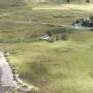
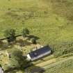
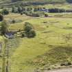
Enclosure, Inchnadamph.
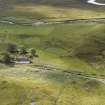
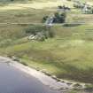
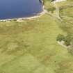
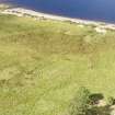
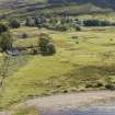
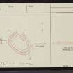
On the haugh, by the side of the graveyard at Inchnadamph, is an oval enclosure surrounded by a bank some 2' to 3' [0.6 - 0.9m] high and 25' [7.6m] broad at base, the interior of which measures 134' x 86' [41m by 26m]. A slight hollow running alongside the mound on its inner side is probably due to the formation of the latter. There appear to be two entrances from the N and E respectively.*
RCAHMS 1911, visited (AOC) 10 June 1909.
*This is said to have been the place where the Chief of the Macleods slept, surrounded by his followers, in time of danger. It is, however, in a very assailable position.
OS 6-inch map: lxxi.
Field Visit (23 May 1962)
Surveyed at 1:10560. (OS GHP) 23 May 1962.
Field Visit (13 August 1974)
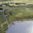
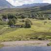
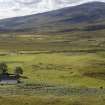
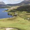
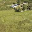
This enclosure is situated on low-lying ground at the head of Loch Assynt. It comprises a silted-up ditch and an outer bank reduced to a present height of 0.7m in the S. Both bank and ditch have apparently been approximately 5.0m wide. Of three breaks in the spread bank, that in the NE has been subject to considerable mutilation, and being at the lowest point of the ditch, is the wettest place in the whole work. Corresponding to the central break in the bank on the E side is a causeway across the ditch, which is the probable original entrance. The third break, in the SE, is recent. The ditch is scarcely strong enough to classify this site as a homestead moat, but a medieval date for it seems reasonable. However, the possibility of it being a henge should not be discounted. (c/f NS56NW 15)
Visited by OS (J M) 13 August 1974.
Field Visit (2 September 1980)
The plan and general appearance of this feature leave little doubt that it is a homestead moat with dimensions as supplied by the previous authorities. It comprises a silted ditch, now dry, which is crossed by a causeway on the longer (NE) side; the outflow appears to have been in the N corner. Material from the ditch has been deposited inside to form a slightly raised, level platform which is featureless, and outside to construct a retaining bank. Significantly, this bank is at its highest in the S arc where a slight lift in the natural ground level has necessitated a deeper cut of ditch. The moat lies adjacent to the parish church; the earliest record of a church hereabouts dates from about 1455. The irregular shape of the work excludes it from consideration as a henge.
Visited by OS (N K B) 2 September 1980
Note (1996)
This site is listed in an Atlas of Scottish History (McNeill and MacQueen 1996) as a moated site.
Information from RCAHMS (DE) September 1997
Field Visit (1996 - 2003)
Russell Coleman managed an Historic Scotland funded project to record medieval moated sites in Scotland. Gazetteers were produced for each regional council area between 1996 and 2002 with an uncompleted overall review in 2002-03. The results of the first year of the project were published in Tayside and Fife Archaeological Journal, Volume 3 (1997).
Project (October 2005)
Geophysical survey NC 248 219 to NC 249 220 Earth resistance and gradiometer survey in October 2005 located the remains of a bank and ditch, 3.5-5m wide. A high resistance anomaly located at the SE end of the central area is interpreted as a possible compacted surface, with the gradiometer data showing possible occupation debris scattered to the N and E. The breaks in the banks to the N and SE are thought to belong to a water management system, with that on the NE linking to a causeway leading from the enclosure towards the old church. The enclosure is surrounded by a system of palaeochannels.
Archive to be deposited in Highland SMR.
Sponsor: Highland Council.
D Hodgson 2005
Magnetometry (October 2005)
Geophysical survey NC 248 219 to NC 249 220 Earth resistance and gradiometer survey in October 2005.
Archive to be deposited in Highland SMR.
Sponsor: Highland Council.
D Hodgson 2005
Earth Resistance Survey (October 2005)
Geophysical survey NC 248 219 to NC 249 220 Earth resistance and gradiometer survey in October 2005.
Archive to be deposited in Highland SMR.
Sponsor: Highland Council.
D Hodgson 2005
Field Visit (28 November 2009)
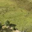
A circular, earthen enclosure bank measuring 40m in diameter and 0.4m high. Truncated in the east, south, north-west and north edges with a wall spread of up to 5m. It is situated in a flat area which is boggy. There is no sign of a definite entrance.
(HLP_ no 135)
Assynt's Hidden Lives Project 2009
Excavation (18 February 2013 - 23 February 2013)
NC 2488 2197 As part of the Assynt Fire and Water Project, an excavation was undertaken, 18–23 February 2013, to investigate the moated enclosure at Inchnadamph. The site has always been enigmatic and prior to excavation it was considered undated. Although the similarity to moated granges of S and E Scotland offered the closest comparanda, the retrieval of fragments of a high-cross from the nearby graveyard, probably of SW Scottish provenance, raised the possibility of the site being an Early Christian site.
Excavation comprised a slot trench placed over the ditch and the exterior bank in the E area of the site, close to one of the probable entrances. The ditch was found to be a broad U-shape in profile, c1.5m deep with a flat base, with the fill largely derived from the erosion of the outer bank.
A large number of artefacts were recovered from the upper deposits, derived mainly from the eroded bank outside the site, and included ceramics similar to Hebridean Craggan Ware, a fragment of a disc-shaped rotary quern, a folding knife and a large quantity of iron working slag, including furnace base cakes. Given the lack of a local ceramic sequence, the pottery is not easily datable, but a post-medieval date is considered probable for the majority of the artefacts.
Waterlogged deposits were encountered at the base of the ditch, and although these could only be investigated to a limited extent, they contained waterlogged wood, including an off-cut of Scots pine, animal and fish bones and a sizable plant macrofossil and insect assemblage. Radiocarbon dates were obtained from samples taken from the upper and basal deposits of the ditch: these are statistically inseparable and indicate activity between the mid-15th and mid-17th century AD.
Funder: Heritage Lottery Fund
Graeme Cavers, Gordon Sleight and Charlotte Douglas, AOC Archaeology Group, 2013
(Source: DES)
Aerial Photography (30 November 2022)
Vertical aerial photographs were captured at Inchnadamph medieval enclosure on 30 November 2022. Images were captured using a DJI Inspire 2 and FC6340 camera and include 130 overlapping vertical images (tif format). No ground control points were recorded. The vertical images were processed using Agisoft Metashape to produce a point cloud and DEM. Visualisations were subsequently produced using the Relief Visualisation Toolbox. The original images, point cloud, metadata and derived products were archived in February 2025.
Information from HES Archaeological Survey (GFG), 10 February 2025.

