
Pricing Change
New pricing for orders of material from this site will come into place shortly. Charges for supply of digital images, digitisation on demand, prints and licensing will be altered.
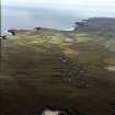
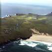
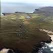
Lewis, Eoropie


Field System (Period Unassigned), Lazy Beds (Post Medieval)
Site Name Lewis, Eoropie
Classification Field System (Period Unassigned), Lazy Beds (Post Medieval)
Canmore ID 129505
Site Number NB56NW 19
NGR NB 5120 6530
NGR Description Centred on NB 5120 6530
Datum OSGB36 - NGR
Permalink http://canmore.org.uk/site/129505


- Council Western Isles
- Parish Barvas
- Former Region Western Isles Islands Area
- Former District Western Isles
- Former County Ross And Cromarty
Note
A field-system which may belong to the crofting township of Eoropie (NB56NW 9) is depicted on the 1st edition of the OS 6-inch map (Island of Lewis, Ross-shire 1853, sheet 1), but it is not shown on the current edition of the OS 1:10000 map (1992).
Information fom RCAHMS (AKK) 13 March 1997

