
Following the launch of trove.scot in February 2025 we are now planning the retiral of some of our webservices. Canmore will be switched off on 24th June 2025. Information about the closure can be found on the HES website: Retiral of HES web services | Historic Environment Scotland
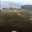
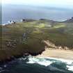
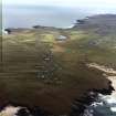
Lewis, Eoropie


Field System (Period Unassigned), Lazy Beds (Post Medieval)
Site Name Lewis, Eoropie
Classification Field System (Period Unassigned), Lazy Beds (Post Medieval)
Canmore ID 129505
Site Number NB56NW 19
NGR NB 5120 6530
NGR Description Centred on NB 5120 6530
Datum OSGB36 - NGR
Permalink http://canmore.org.uk/site/129505


- Council Western Isles
- Parish Barvas
- Former Region Western Isles Islands Area
- Former District Western Isles
- Former County Ross And Cromarty
Note
A field-system which may belong to the crofting township of Eoropie (NB56NW 9) is depicted on the 1st edition of the OS 6-inch map (Island of Lewis, Ross-shire 1853, sheet 1), but it is not shown on the current edition of the OS 1:10000 map (1992).
Information fom RCAHMS (AKK) 13 March 1997

