
Pricing Change
New pricing for orders of material from this site will come into place shortly. Charges for supply of digital images, digitisation on demand, prints and licensing will be altered.
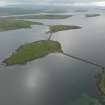
Churchill Barrier No. 1, Mainland To Lamb Holm


Causeway (20th Century)
Site Name Churchill Barrier No. 1, Mainland To Lamb Holm
Classification Causeway (20th Century)
Alternative Name(s) Scapa Flow; Churchill Causeway; Kirk Sound
Canmore ID 2379
Site Number HY40SE 25
NGR HY 4843 0100
NGR Description HY 4840 0126 to HY 4848 0069
Datum OSGB36 - NGR
Permalink http://canmore.org.uk/site/2379


- Council Orkney Islands
- Parish Holm
- Former Region Orkney Islands Area
- Former District Orkney
- Former County Orkney
In the First and Second World Wars, Scapa Flow was a major strategic base for the Royal Navy. In the First World War, blockships were sunk across the eastern approaches to the Flow and these defences were strengthened during the Second World War following the torpedoing of HMS Royal Oak in October 1939. In 1940-2, following a directive from Winston Churchill, four causeways, built of concrete blocks, were constructed by a workforce of up to 1720 men, 1200 of whom were Italian prisoners-of-war. The causeways subsequently became known as the Churchill Barriers.
Information from RCAHMS (SC) 4 July 2007
Hewison, WS 1995
Gifford, J 1992
HY40SE 25 4840 0126 (HY 4840 0126 to HY 4848 0069)
See also:
ND49NW 2 ND 4412 9670 to ND 4452 9641 Hunda Reef Barrier
ND49NE 15 ND 4822 9999 to ND 4785 9952 Churchill Barrier No. 2, Lamb Holm to Glimps Holm (Holm Sound)
ND49NE 16 ND 4730 9870 to ND 4744 9833 Churchill Barrier No. 3, Glimps Holm to Burray (Weddel Sound)
ND49NE 17 ND 4802 9543 to ND 4770 9495 Churchill Barrier No. 4, Burray To South Ronaldsay (Water Sound)
See also corresponding (predecessor) blockships:
HY40SE 8009 Numidian
HY40SE 8013 Thames
HY40SE 8003 Busk
HY20NW 8006 Tarbarka
HY40SE 8001 Lake Neuchatel
HY40SE 8004 Mineh
HY40SE 8007 Redstone
HY40SE 8005 Seriano
HY40SE 8008 Gambhira
HY50SW 8001 Aorangi
Churchill Causeway (No 1) [NAT]
OS 1:10,000 map, 1970.
Visible on air photographs (OS 63/45/146-7, flown 1963)
(Undated) information in NMRS.
The most northerly of 4 concrete block causeways carrying the A961 road. Construction began in 1940 using some Italian prisoners of war but mostly civilian contractors.
Visited by R G Lamb, 1980
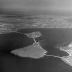
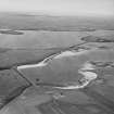
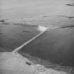
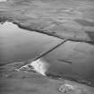
The Churchill Barrier was completed in the latter stages of World War II. Vertical air photographs taken during WW II (WL/10 2.22-2.23, flown 4 July 1942 show construction at an early stage, before visible signs of the barrier were showing. Five of the blockships listed above are also visible on the photographs as well as the construction camps on the S shore of the mainland and part of the Italian Prisoner-of-war camp on the N shore of Lamb Holm. The steel towers used in the construction of the barriers can also be seen.
The completed barriers, with abandoned construction camps, are visible on a postwar RAF vertical air photograph (106G/Scot/UK 137, 3014, flown 3 July 1946).
Information from RCAHMS (DE), December 2004.
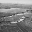
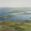
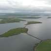
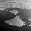
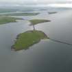
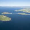
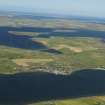
This causeway carries the A961 public road across Kirk Sound, between the Mainland and Lamb Holm. Kirk Sound is the most northerly of the four sounds on the E side of Scapa Flow.
Information from RCAHMS (RJCM), 10 May 2006.
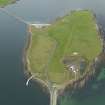
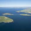
Kirk Sound is not noted as such on the 1998 edition of the OS 1:50,000 map. The name applies to the most northerly of the sounds on the E side of Scapa Flow, beteween Lamb Holm (to the S) and St Mary's village, Holm, Mainland (to the N). It is centred at HY 484 010, and is spanned by Churchill Barrier No. 1 (HY40SE 25).
Information from RCAHMS (RJCM), 21 March 2007.
Construction (1940 - 1946)
The Churchill Barrier was completed in the latter stages of World War II. Vertical air photographs taken during WW II (WL/10 2.22-2.23, flown 4 July 1942 show construction at an early stage, before visible signs of the barrier were showing. Five of the blockships listed above are also visible on the photographs as well as the construction camps on the S shore of the mainland and part of the Italian Prisoner-of-war camp on the N shore of Lamb Holm. The steel towers used in the construction of the barriers can also be seen.
The completed barriers, with abandoned construction camps, are visible on a postwar RAF vertical air photograph (106G/Scot/UK 137, 3014, flown 3 July 1946).
Publication Account (1996)
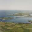
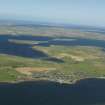
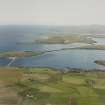
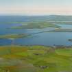
There are four barriers spanning the sounds between mainland, Lamb Holm, Glims Holm, Burray and South Ronaldsay, a total length of some 2.3km. They were built during the Second World War with the object of blocking the four eastern approaches to Scapa Flow, as part of an attempt to create a safe anchorage for the British Home Fleet. Massive concrete blocks were made and set in position by Italian prisoners-of-war and, after the war, the barriers were surfaced as a foundation for the modern road. The predecessors of the barriers, the block-ships sunk during the First World War for the same strategic purpose, can be seen alongside.
The first stage in the construction of the barriers was to lay down a rubble base: in some places the water was up to 18m deep, and it took a quarter of million tons of stone and rubble to complete the foundation, most of it from a quarry on Lamb Holm. The casting yard for the concrete blocks was at St Mary's Holm, where some 66,000 blocks were made, weighing five or ten tons each, and these were laid on top of the rubble base. The barriers also provide an insight into the results of human intervention in the natural environment, because over the four decades since they were built there has been a massive accumulation of sand against them.
Information from ‘Exploring Scotland’s Heritage: Orkney’, (1996).
Publication Account (2007)
Churchill Barriers, East Mainland – South Ronaldsay, Orkney
(Institute Civil Engineers Historic Engineering Works no. HEW 1984)
Scapa Flow was ideally suited to serve as the wartime fleet anchorage for the Royal Navy in both world wars, but the four main channels on the eastern side of the Flow were known to be weak spots in its defence against enemy submarines and torpedo-carrying craft. In 1915, William (later Sir William) Halcrow was invited to consider the building of permanent barriers across these channels, but sunken blockships were considered to be a more expedient solution. Some of the blockships were later removed or shifted their positions, and their defence inadequacies were exposed in October 1939 when a German U-boat found a way round them in Kirk or Holm Sound, the deepest and fastest flowing of these channels. It torpedoed the battleship HMS Royal Oak, with the loss of 833 lives, and escaped by the same route.
This dramatic episode at the very start of the second world war prompted the construction of permanent barriers across the four channels, a scheme which was finally authorised by Churchill himself after a visit in person in March 1940, hence their name. On-site preparations commenced in May 1940, and during the summer of 1940 limited experiments were conducted on models in the Whitworth Engineering Laboratories at the University of Manchester.
Not finally breaking the surfaces of the channels until 1942–43, the barriers became recognised as causeways for potential civilian use, and a relaxed interpretation of the Geneva Convention allowed the labour force to be augmented substantially by Italian prisoners-of-war from early 1942 onwards. At its peak in 1943 numbers engaged in the operation reached about 2000. Costing some £2 million, the works were effectively completed in September 1944 but were not officially opened until 12 May 1945, four days after VE day.
The contractors for this feat of engineering and organisation were Balfour Beatty & Co. Ltd, the southern section of the southernmost barrier being sub-contracted to William Tawse & Company, Perth. Founded by George Balfour and Andrew Beatty in 1909 as general and electrical engineering contractors, by 1937 the firm of Balfour Beatty had established a major presence on the other side of Scapa Flow, building the additional above-ground oil tanks at
Lyness on Hoy.
The barrier scheme was designed and supervised by Sir Arthur Whitaker, Civil Engineer-in-Chief of the Admiralty, and was carried out under the direction of H. B. Hurst who was succeeded by C. K. Johnstone-Burt, Herbert Chatley and J. A. Seath. Until 1942 the Resident Superintending Civil Engineer was E. K. Adamson, and from 1942 until completion it was G. Gordon Nicol, whose notes and photographs preserved in the Orkney Archives in Kirkwall constitute a valuable record of the work of construction. A special feature was the use of five aerial cableways, four electrically-driven, one steam-powered, by John M.
Henderson & Co. Ltd, Aberdeen. Nicknamed ‘Blondins’ after the French acrobat and tightrope walker, Jean Blondin, two of the cableways were paired across Kirk Sound, the deepest of the channels. Designed to absorb a through 4–5 knot tidal current, the structure of the four barriers consists of a core of rubble bolsters cloaked by 5 ton concrete blocks below the water line. Except in the case of the less exposed Weddel Sound, which is of 5 ton blocks throughout, these are in turn overlaid by 10 ton blocks, the outer skin being laid in ‘pell-mell’ fashion to break the force of the waves.
The barriers measure some 1 1/2 miles in overall length, linking East Mainland to South Ronaldsay via the three islands (north–south) of Lamb Holm, Glims Holm and Burray. The widest and deepest channel was the northernmost, Kirk or Holm Sound between Mainland and Lamb Holm, where the foundations of what became No. 1 Barrier were laid in fast-flowing tidal water up to 59 ft in depth. In total, the barriers consumed about 250 000 tons
of quarried rubble overlaid by some 66 000 concrete blocks from the casting yards at St Mary’s and on Burray.
The sites of the accommodation camps, rubble quarries, the concrete blockyards and the associated railways are still traceable on the ground, and a chapel on Lamb Holm, cleverly wrought out of two Nissen huts, remains a picturesque memorial to the Italian contribution. (G. Stell)
R Paxton and J Shipway, 2007.
Reproduced from 'Civil Engineering heritage: Scotland - Highlands and Islands' with kind permission from Thomas Telford Publishers.
Watching Brief (8 August 2013 - 9 October 2013)
A watching brief undertaken on and at either end of The Churchill Barriers (Barriers 1, 2 and 4), and at West Greaves, Orkney as part of a Scottish Water pipe replacement and improvement scheme. 16 small trenches were monitored between July and October 2013. No features of archaeological interest were uncovered.
Information from L Somerville - Orkney Research Centre for Archaeology (ORCA).
OASIS ID: orkneyre1-166213

