
Pricing Change
New pricing for orders of material from this site will come into place shortly. Charges for supply of digital images, digitisation on demand, prints and licensing will be altered.
Brough Of Birsay


Chapel (12th Century), Settlement (12th Century)
Site Name Brough Of Birsay
Classification Chapel (12th Century), Settlement (12th Century)
Alternative Name(s) St Peter's Chapel; St Peter's Monastery
Canmore ID 1796
Site Number HY22NW 1
NGR HY 23977 28513
Datum OSGB36 - NGR
Permalink http://canmore.org.uk/site/1796


First 100 images shown. See the Collections panel (below) for a link to all digital images.
- Council Orkney Islands
- Parish Birsay And Harray
- Former Region Orkney Islands Area
- Former District Orkney
- Former County Orkney
HY22NW 1.00 23977 28513
HY22NW 1.01 HY 2398 2850 Pictish Symbol Stone
HY22NW 1.02 HY 2399 2850 Cross-slabs
(HY 239 285) St Peter's Chapel (NR) (Remains of) Burial Ground (NR)
OS 6" map, Orkney, 2nd ed., (1900).
The first settlement on this site was a possibly 6th century Celtic monastic establishment, the chapel, grave-yard (beneath that of the later Norse settlement), and enclosing wall of which have been identified by Radford. The name of St Columba or St Colm has been associated with the site, but on no very good authority.
This was followed by early 9th century Viking farmsteads which had developed into a Norse settlement by the middle of the 11th century, when, according to Radford, the famous 'Christ Church' of Earl Thorfinn - the first Norse Christian church in Orkney - was erected, on the site of the Celtic chapel (but see HY22NW 8). Radford also believes that he has located Earl Thorfinn's Hall.
The foundation date of the early 12th century Cathedral (traditionally dedicated to St Peter) is not known, but it was superseded by the erection of Kirkwall Cathedral in the mid-12th century. However, the contemporary Bishop's Palace, to the north of the cathedral, remained in use at least until the 14th century (by the 16th century the bishops were apparently using a house on the mainland.)
The cathedral probably remained in use as a parish church until the erection of a successor on the mainland (HY22NW 8), possibly in the 13th century: it was a place of pilgrimage until the Reformation.
C A Ralegh Radford 1959; RCAHMS 1946; C A Ralegh Radford 1962.
As described by the above authorities.
Surveyed at 1/2500
Visited by OS(RL) 25 May 1967.
There are Viking houses along the cliff edge (between HY 2367 2827 and HY 2399 2846).
Information taken from Orkney Survey of 1960 [On an annotated map by Wainwright in the possession of MOPBW (now Historic Scotland)].
Group of bobble-headed pins.
L Laing and J Laing 1986.
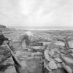
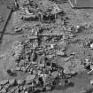
Winter storms in January 1993 exposed walling and occupation debris in the cliff-face immediately to the N of the entrance to the Brough of Birsay. Photography, cleaning and recording of the exposed section, and limited excavation of damaged areas took place in July 1993. Eleven periods of activity were noted, with at least three seperated phases of wall-construction below the extant consolidated walls. The sequences appear to be broadly similar to those recorded below Room 5 in 1973-4. Occupation and/or midden deposits included much mammal bone and shell, and these were sampled as fully as possible within the parameters of the exercise. There was little artefactual material recovered. Sponsor: Historic Scotland
C D Morris 1993
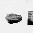
Class I symbol stone with mirror case and to its left a crescent and V-rod above an elephant and an eagle.
A Mack 1997.
Field Visit (25 May 1967)
As described by the above authorities.
Surveyed at 1/2500
Visited by OS(RL) 25 May 1967.
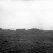
Aerial Photography (1971)
Oblique aerial photographs of Brough of Birsay, Orkney, by John Dewar in 1971.
Publication Account (1996)
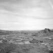
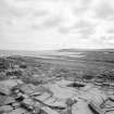
To see the Brough of Birsay in summer is to appreciate its attraction for settlement: as a tidal island it is defensible and yet not isolated, and it is situated so as to enjoy all the advantages of this favoured corner of Orkney with its fertile land and sheltered landing places. The island is about 21 hectares in extent, sloping up from about 4m OD on its east side to the sheer western cliffs, some 45m high, where puffins live. The gentle slope facing mainland belies the incred ible force of the Atlantic waves that reak against its western face, for in winter the sea-spray rises so high that the entire island is washed by salt water; in Viking times, however, the climate was appreciably better than now, with an average mean temperature about 2°C higher, an enormous boon to the arable farmer and a calming influence on the winter storms,
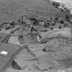
Although the Brough was undoubtedly already a tidal island by late prehistoric times, there has been appalling coastal erosion over the last eight centuries, and much structural evidence of settlement has been lost into the sea, not only adjacent to the central area of buildings east of the church, where house walls and the boat slipway stop abruptly at the cliff edge, but also along the coast on either side, Recent excavations have concentrated on recording what is left of Vikingage and Pictish building along the cliff-edge and on the slice of land that will one day collapse into the sea, known as the Peerie Brough, the little Brough. This means that what has survived as a substantial archaeological site was originally considerably more extensive.
In Norse times, from around AD 800 until the 12th century or perhaps a little later, there was a major settlement here which must always have possessed a rather different status and character from the normal farm, if only because normal farming was impossible on the tiny island itself and must have been supplemented by the produce of fields and pastures on the adjacent mainland, It is possible that the home farm during the 9th century was the site which has been excavated bur which is no longer visible on the Point of Buckquoy, where a dwelling-house, barn-byre and threshing barn were discovered, Cattle, sheep and pigs were reared on the Buckquoy farm, whereas the animal bones from excavations on the Brough suggest very logically that sheep were probably grazed on the island itself and beef was brought over ready slaughtered as joints.
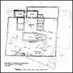
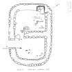
The visible buildings are dominated by the church, a fine Romanesque creation which was probably built in the early 12th century; it is very small (the nave is only 8.5m by 5.8m internally) but is design is quite sophisticated, with a square chancel and a semi-circular apse at the east end and traces of a probable square tower at the west end . There are semi-circular recesses for altars in the nave, on either side of the chancel arch, and the main altar, which was originally in the apse, is now in the chancel, whence it was moved in later medieval times when the church was a place of pilgrimage (the altar has also been restored in modern times). The proportions of the church and the warm colour of the sandstone are very pleasing, and the stone bench lining the north, south and west walls of the nave gives an excellent impression of its internal lay-our in the days before wooden pews.
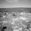
To the north of the church are three ranges of buildings which, with the church on its fourth side, enclose a courtyard. This is thought by some scholars to have formed the kernel of a Benedictine monastery, although unfortunately there is no documentary evidence to identify with certainty either its monastic status or the order to which the monastery belonged. The foundation of this early medieval church represents a return to an ecclesiastical status, for the site had an Early Christian chapel in pre-Norse times, but during the intervening 300 years the settlement is likely to have been purely secular.
At one time the church was thought to be the Christchurch built by Earl Thorfinn after his pilgrimage to Rome around 1050 and the buildings to the north of the church to be the Bishop's Palace of the earliest bishops of the Northern Isles, but it is now agreed that the church was built more than half a century later and that Christchurch and the seat of the bishopric were on the mainland beneath the modern village of Birsay (see no. 38).
The major problem in trying to analyse the various upstanding buildings on the Brough is that the original excavations of the 1930s and 1950s have never been published, apart from a catalogue and discussion of the marvellous range of small finds. The complex of domestic structures to the east of the church represents a sequence spanning the 9th to 12th centuries to judge from the finds. The isolated houses upslope from the church appear to be normal Viking-age domestic hall-houses. Later excavations along the cliff-edge in the 1970s and 1980s have expanded our understanding of this important settlement.
Prior to the arrival of the Norsemen, there was a thriving Pictish community on the island; it is sometimes assumed to have been monastic, because of traces of an earlier chapel beneath the surviving church and earlier graves in the graveyard (literally at a lower level than the later graves), but the chapel may have served a lay community. Few structural traces of the Pictish settlement have been found, perhaps because, unexpectedly, they appear to have been timber-built, apart from the small stone-lined well to the east of the church; although it is only 0.75m deep, it seems to have provided a watersupply for a bronze-workshop in the vicinity, for the area round about, when excavated in the 1930s, yielded many fragments of broken moulds, crucibles and bronze plating. Prestigious objects were being made here, mostly brooches, fingerrings and dress-pins, and they imply wealthy patronage. Elsewhere in Scotland, such metalworking is associated with the fortified residences of Dark-Age chieftains, such as Dunadd in Argyll, and it seems likely that the Brough, which is in a sense defended by the sea, was also the seat in the 8th century of an important chieftain, perhaps the chieftain depicted on the symbol stone.
The original symbol stone was found shattered into fragments and it is now in the Royal Museum of Scotland in Edinburgh, but a cast has been put up on site. It is an unusual stone in its composition of design and combination of carving techniques: at least four incised Pictish, symbols occupied the upper part of the slab, while incised in a shallow recessed panel beneath are three warriors. The symbols are common enough in the Pictish repertoire: a circular decorated disc which is part of the so-called ' mirror case' symbol, a crescent and V-rod, a 'swimming elephant' or Pictish beast, and an eagle; the bearded warriors are carved with a fine attention to detail, each dressed in a long tunic with sword-belt and a sword-scabbard hanging at their left sides, each carrying a tall spear and a square shield. The rivets holding the hand-grip to the back of the shields are shown as pairs of circles, and the shield held by the leading warrior is decorated. The leader is also di stinguished by the decorative hem of his tunic, by the size of his spear (even the midrib of his cast metal spearhead is indicated), and by his curls.
Information from ‘Exploring Scotland’s Heritage: Orkney’, (1996).
Orkney Smr Note
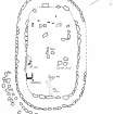
The group of Viking Buildings consists of an intricate arrangement of thirteen compartments with passages and small courts covering an area of approx 100ft square. The walls area an average height of about 2ft and vary considerably in thickness. The compartments range in size from 12ft x 11ft to 25ft x 12ft and were presumably covered with thatched roofs. RCAHMS 1946 pp1-5 and 7
Information from Orkney SMR [n.d.]

