
Pricing Change
New pricing for orders of material from this site will come into place shortly. Charges for supply of digital images, digitisation on demand, prints and licensing will be altered.
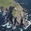
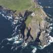
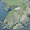
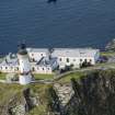
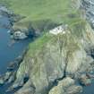
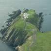
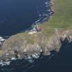
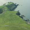
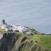
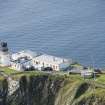
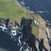
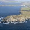
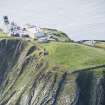
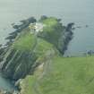
Sumburgh, Chain Home Low Radar Station


Radar Station (20th Century)
Site Name Sumburgh, Chain Home Low Radar Station
Classification Radar Station (20th Century)
Alternative Name(s) Sumburgh Lighthouse; Sumburgh Head
Canmore ID 115254
Site Number HU40NW 4
NGR HU 4072 0788
NGR Description Centred HU 4072 0788
Datum OSGB36 - NGR
Permalink http://canmore.org.uk/site/115254


- Council Shetland Islands
- Parish Dunrossness
- Former Region Shetland Islands Area
- Former District Shetland
- Former County Shetland
HU40NW 4 centred 4072 0788
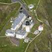
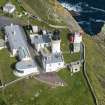
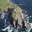
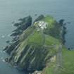
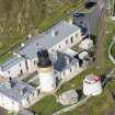
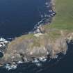
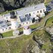
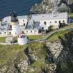
This Chain Home Low Radar Station is situated within the boundary of the lighthouse buildings. The transmitter(Tx) and receiver (Rx) blocks along with the engine room and tower bases are extant.
One of the early types of Chain Home Low radar station, begun as separate transmitting and receiver aerials which were later combined into one. Due to interference from the lighthouse buildings the radar station was moved to Compass Head (HU40NW 5) just to the N.
J Guy 1995; NMRS MS 810/4, 61-4
Additonal information provided by Mr I Brown states that the station was replaced by Grutness (HU40NW 5).
Information from Mr I Brown, 19 October 1998.
The radar station is visible on vertical air photographs (106G/scot/UK 97, 4025-4026, 18 May 1946), which shows that the buildings are situated at several points within the lighthouse boundary.
The buildings are constructed of brick, brick and shuttered concrete two of which have blast walls in from of the entrances. One building is adjacent to the lighthuse fog horn.
Information from RCAHMS (DE), January 2006
This station was never a Chain Home Low radar installation.
Information via e-mail from Mr I Brown, 21 October 2005
Watching Brief (December 2011)
HU 40723 07872 Since December 2011 a programme of archaeological work has been ongoing at Sumburgh Head, as part of a restoration and adaptive reuse project. This project includes the refurbishment of the 19th- and early 20th-century lighthouse buildings, the creation of a marine life centre and a new education room at one of the most accessible bird colonies in the United Kingdom. The cultural heritage forms a significant interpretive element of the project with the site of an Iron Age fort and surviving WW2 radar station located within the lighthouse complex. The archaeological monitoring has consisted of evaluation trenches, in advance of groundwork, complemented by watching briefs.
The site of an Iron Age fort at Sumburgh Head features on a 17th-century map and a written description was compiled during the late 18th century. The earthwork ramparts survive c150m to the N of the lighthouse and were annotated on the 1st Edition OS map of the area. An evaluation was undertaken on the site of the fort ramparts in advance of the construction of a new water pump house. No structural remains were identified, although three historic ground surfaces were recorded, representing historic remodeling of the area and soil micromorphology samples were taken from these surfaces. In addition, five evaluation trenches were dug in the W field in advance of the installation of a ground source heat pump. No archaeological finds or features were recorded in this steeply sloping field.
Watching briefs have been undertaken in association with new car parks, cabling and associated infrastructure works. In the area adjacent to the fog horn a 20th-century brick-lined pit was discovered, which may have been an ammunition store for a wartime Lewis Gun position. To the S of the East Pavilion a mass concrete blast wall was found in a recumbent position and this viewed in association with documentary material, indicates an air raid shelter existed within the lighthouse complex. Machine excavations for a new stone dyke in the vicinity of the Iron Age rampart and wartime Nissen hut foundations led to the discovery of several .303 bullet casings, a button and possible part of a cap badge, relating to the wartime usage of the site.
Archive: Shetland Amenity Trust. Report: Shetland Amenity Trust and RCAHMS (intended)
Funder: Shetland Amenity Trust
Chris Dyer, Shetland Amenity Trust, 2013
(Source: DES)

