
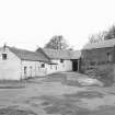
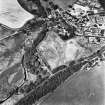
Clovenfords, Caddon Mill


Grain Mill (Period Unassigned)
Site Name Clovenfords, Caddon Mill
Classification Grain Mill (Period Unassigned)
Alternative Name(s) Cadon Mill
Canmore ID 99652
Site Number NT43NW 39
NGR NT 4462 3632
NGR Description Centred on NT 4462 3632
Datum OSGB36 - NGR
Permalink http://canmore.org.uk/site/99652


- Council Scottish Borders, The
- Parish Caddonfoot
- Former Region Borders
- Former District Ettrick And Lauderdale
- Former County Selkirkshire
NT43NW 39 4462 3632
Caddon Mill is named as Cadon Mill and depicted on the 1st edition of the OS 6-inch map (Selkirkshire, 1863, sheet VII).
Information from RCAHMS (AB) 3 June 1999.
Sbc Note
Visibility: Evidence for this site, or the origins of this site, comes from documentary sources. Nothing may be visible at this location.
Information from SBC.

