
Pricing Change
New pricing for orders of material from this site will come into place shortly. Charges for supply of digital images, digitisation on demand, prints and licensing will be altered.
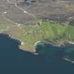
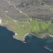
Raasay, General


General View (Period Unassigned)
Site Name Raasay, General
Classification General View (Period Unassigned)
Canmore ID 99566
Site Number NG53NE 104
NGR NG 56665 42493
NGR Description Centred on NG 56665 42493
Datum OSGB36 - NGR
Permalink http://canmore.org.uk/site/99566


- Council Highland
- Parish Portree
- Former Region Highland
- Former District Skye And Lochalsh
- Former County Inverness-shire
RAASAY (Roe-Isle - Old Norse). Raasay, with its sister isle of Rona, lies sheltered between the corrugated flank of Trotternish and the axehead peninsula of Applecross. A table of rough moorland (rising to over 800 ft and once heavily wooded) runs down its spine, descending eastwards to empty, cliff-edged slopes and westwards to lower fertile pastures, sheltered copses of natural birch, and ornamental plantings now threaded with commercial forestry. Volcanic Dun Caan presides over a landscape and buildings that represent in microcosm the geography and social history of the Inner Hebrides.
Raasay and Rona formed part of the lands belonging to the Bishops of the Isles, controlled from 1266 by the Earls of Ross. By 1493, when the Lordship of the Isles broke up, the Macleods of Raasay - known as 'MacGilleChaluim' and descended, some say from the Macleods of Lewis, others say from the Macleods of Gairloch - were in control; they received a charter for their lands in 1596. More effectively than other Hebridean lairds, they succeeded in transforming themselves in just a few generations from roving pirates to gentlemen of cultured taste. Something of the Arcadian landscape they created here in the eighteenth century can still be seen, despite the vicissitudes of the last 150 years. After the bankruptcy of John, 13th chief, and his emigration to Tasmania in 1843, a new proprietor, George Rainy, instigated a mass clearance to make way for sheep walks, while simultaneously improving the estate and its buildings. By 1872 Raasay had again changed hands. Over the next half century it was to pass through various different owners, during which time a substantial portion of its southern half was transformed into a deer forest. In 1923 the Board of Agriculture for Scotland bought the island, resettled crofters and in 1949 granted land to the Forestry Commission. The Scottish Office still owns Raasay today.
Taken from "Western Seaboard: An Illustrated Architectural Guide", by Mary Miers, 2008. Published by the Rutland Press http://www.rias.org.uk


