
South Uist, West Gerinish, Loch Cille Bhanain


Chapel (Medieval)(Possible), Dun (Prehistoric)
Site Name South Uist, West Gerinish, Loch Cille Bhanain
Classification Chapel (Medieval)(Possible), Dun (Prehistoric)
Alternative Name(s) West Geirnish
Canmore ID 9924
Site Number NF74SE 1
NGR NF 7685 4138
Datum OSGB36 - NGR
Permalink http://canmore.org.uk/site/9924


- Council Western Isles
- Parish South Uist
- Former Region Western Isles Islands Area
- Former District Western Isles
- Former County Inverness-shire
NF74SE 1 7685 4138
(NF 7685 4138) Chapel (NR) (In Ruins)
OS 6" map, Inverness-shire, 2nd ed., (1904)
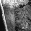
The Commission investigator expresses doubts that the ruined building, on a small promontory on the northern shore of Loch Cille Bhanain, South Uist, shown by the OS as a chapel, is in fact a chapel. It is 54ft long, and 23ft broad over walls 3ft 5ins thick, and is orientated almost due north-south. In 1915, the walls stood about 6ft above the interior. The building is partly built on the site of a dun, the remains of which can be seen outside the south gable and the south end of the west wall. The external diameter is about 47ft NW-SE.
RCAHMS 1928
There is a Chapel of St. Bannan in South Uist.
M Martin 1934
The remains of this building are as described by RCAHMS. No further information was obtained as to the date or its purpose. The remains of the dun consist of the outer face of the south perimeter, formed by large stones and c.0.8m high. A few stones here and there outline the probable course of the remainder of the outer face giving the dun an oval shape, measuring c18.0m NE-SW by c 15.0m transversly.
Revised at 1:2500
Visited by OS (W D J) 13 May 1965.
Field Visit (26 June 1915)
Chapel (ruins of) and Dun, Loch Cille Bhanain, West Geirnish.
On a small promontory on the northern shore of Loch Cille Bhanain, which lies to the south of the western extremity of the township of West Geirnish, is a ruined building marked "Chapel in ruins" on O.S. map. The name of the loch suggests that there had been a church near it in olden times, but judging from the orientation it is doubtful if this ruin was ever a church. It is oblong on plan, and is built almost due north and south. It measures some 54 feet in length, and 23 feet in breadth externally, the wall being about 3 feet 5 inches thick, and still standing to a height of about 6 feet above the interior. Though it has been pointed with lime in the interior, there is no trace of mortar within the wall, but possibly it has got washed out as in the case of the church at Balivanich in Benbecula. It is in danger of collapsing in different places, as the facing stones both inside and outside have become displaced, and the wall is gradually splitting. In the eastern wall, some 15 feet 6 inches from the north-east corner, is the southern jamb of the door, but the opposite side is quite destroyed. No windows can be detected in the building.
This structure has been built partly on the site of a dun, the remains of which can be seen outside the southern gable and south end of the west wall. The dun has apparently been circular with a diameter of some 47 feet externally from north-west to south-east. One or two courses containing large blocks of stone, well built, remain in position on the outside of the south-western half of the circle.
RCAHMS 1928, visited 26 June 1915.
OS map: South Uist xlviii.

