
South Uist, Eochar, Dun Na Buail' Uachdraich


Broch (Iron Age)(Possible)
Site Name South Uist, Eochar, Dun Na Buail' Uachdraich
Classification Broch (Iron Age)(Possible)
Alternative Name(s) Dun Na Buail'-vachdraich
Canmore ID 9918
Site Number NF74NE 5
NGR NF 77762 46074
Datum OSGB36 - NGR
Permalink http://canmore.org.uk/site/9918


- Council Western Isles
- Parish South Uist
- Former Region Western Isles Islands Area
- Former District Western Isles
- Former County Inverness-shire
NF74NE 5 7777 4606.
(NF 7777 4646) Dun na Buail' - Uachdraich (NR)
OS 6"map, Inverness-shire, 2nd ed., (1904)
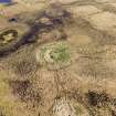
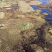
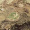
The lowering of the level of the water of Loch Dun na Buail'-uachdraich, near Carnan, South Uist, has left the southern half a swamp. On a mound in this reedy swamp are the remains of Dun na Buail'-uachdraich, a circular stone-walled fort, 50ft in diameter over walls more than 12ft broad and 5ft high in places. The whole of the northern half has been removed. Two or three courses of the outer face of the wall are undisturbed, and these show all the characteristics of broch building. "A ring of stones about 10ft wide at 30 to 45ft from the inner wall, is all that remains of an outer wall surrounding the main defense".
RCAHMS 1928.
Dun no Buail'-uachdraich is as described above. No trace of the inner face of the wall can now be seen although five courses of the outer wall are still visible, the base stones are rather small to be those of a broch.
Re-surveyed at 1:2500.
Visited by OS (R D) 18 May 1965.
Field Visit (5 July 1915)
Dun na Buail'-uachdraich.
Some 200 yards south of the school at Buail'-uachdraich, near Carnan, is a small loch called Loch Dunna Buail' -uachdraich, the southern end of which terminates in swampy ground. On a mound in this reedy swamp formed by the lowering of the outfall from the loch, is Dun na Buail'-uachdraich. This has been a circular stone-walled fort, but the whole of the northern half has been removed, and all that remains is a semicircular bank of stone and earth on the southern side, more than 12 feet broad and some 5 feet in height. The dun has been about 50 feet in diameter externally. Two and three courses of the outer face of the wall are undisturbed, and these show all the characteristics of broch building. There has been an outer wall surrounding the main defence, but it is also greatly dilapidated, and only the southern half of the circle is traceable. Its remains form a ring of stones about 10 feet in width, at a distance varying from 30 to 45 feet from the inner wall.
RCAHMS 1928, visited 5 July 1915.
OS map: South Uist xlviii.
Publication Account (2007)
NF74 4 DUN na BUAILE UACHDRAICH
NF/7777 4646
This probable broch near Carnan in South Uist stands on a mound in swampy ground which was once part of Loch Dun na Buail'-uachdraich before the water level was lowered. In 1915 the remains of a circular, stone-walled stronghold could be seen with a diameter of 15.3m (50 ft) and a wall 3.7m (12 ft) thick and standing up to 1.5m (5 ft) high in places. The whole of the northern half had been removed but two or three courses of the outer face remained in places and "these show all the characteristics of broch building." [2] All traces of the inner face had disappeared by 1965 although up to five courses of the outer wall could be seen; these "are rather small to be those of a broch." [1]
Sources: 1. NMRS site no. NF 74 NE 5: 2. RCAHMS 1928, 108-09, no. 374.
E W MacKie 2007
Measured Survey (26 March 2025)
Measured survey of Dun na Buail' Uachdraich, Eochar, using survey-grade GNSS and UAV photography with ground targets (for Structure from Motion). Information to follow.

