
Pricing Change
New pricing for orders of material from this site will come into place shortly. Charges for supply of digital images, digitisation on demand, prints and licensing will be altered.
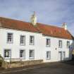
Crail, 5 Rumford


House (17th Century)
Site Name Crail, 5 Rumford
Classification House (17th Century)
Alternative Name(s) 6 Rumford
Canmore ID 99058
Site Number NO60NW 40
NGR NO 61324 07602
Datum OSGB36 - NGR
Permalink http://canmore.org.uk/site/99058


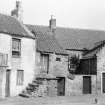

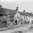
- Council Fife
- Parish Crail
- Former Region Fife
- Former District North East Fife
- Former County Fife
NO60NW 5.00 6135 0763
NO60NW 5.01 NO 613 076 Well; Drains; Pit

