
South Uist, Stoneybridge, Crois Chnoca Breaca


Standing Stone (Prehistoric)
Site Name South Uist, Stoneybridge, Crois Chnoca Breaca
Classification Standing Stone (Prehistoric)
Canmore ID 9899
Site Number NF73SW 3
NGR NF 7340 3366
Datum OSGB36 - NGR
Permalink http://canmore.org.uk/site/9899


- Council Western Isles
- Parish South Uist
- Former Region Western Isles Islands Area
- Former District Western Isles
- Former County Inverness-shire
NF73SW 3 7340 3366.
(NF 7340 3366) Crois Chnoca Breaca (NR)
OS 6"map, Inverness-shire, 2nd ed., (1928)
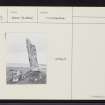
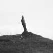
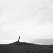
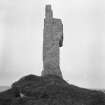
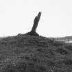
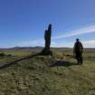
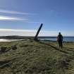
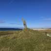
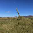
On a small mound about 6ft high, about 100 yards from the shore to the west of Stoneybridge, there is a standing stone 6ft 8ins. high, 1ft 4ins broad at the base and 9ins thick. Although shaped like a cross with one arm broken off (hence the name "Crois Chnoca Breaca") it is a natural formation (RCAHMS 1928). Incorrectly described as a chambered cairn on OS 1"map, (sheet No. 23)
RCAHMS 1928; A S Henshall 1972; Information from A.O. archive 930/4.
The stone is as described by RCAHMS; the grass-covered mound of stones on which it stands is probably packing material. The name is still known locally.
Re-surveyed at 1:2500.
Visited by OS (N K B) 10 May 1965.
Field Visit (25 August 1914)
Standing Stone, Crois Chnoca Breaca, Stoneybridge.
At Cnoca Breac, about 100 yards from the sea-shore to the west of the township of Stoneybridge, on the summit of a small mound about 6 feet high, is a standing stone facing the north-west with a considerable incline in that direction. It measures 6 feet 8 inches in height, 1 foot 4 inches in bread that the base, and 9 inches in thickness. It is shaped like a cross with one arm broken off, hence the name Crois Chnoca Breaca, but it is quite a natural formation. (Fig. 121.)
RCAHMS 1928, visited 25 August 1914.
OS map: South Uist liii.
Measured Survey (28 March 2025)
Measured survey of Crois Chnoca Breaca using survey-grade GNSS, ground and UAV photography with ground targets (for Structure from Motion). Information to follow.

